Map of Davis County - Davis County is a county located in the U.S. state of Utah. Davis County Map showing cities, highways, important places and water bodies. Get Where is Davis County located in the map, major cities in Davis county, population, areas, and places of interest.
Map of Davis County, Utah
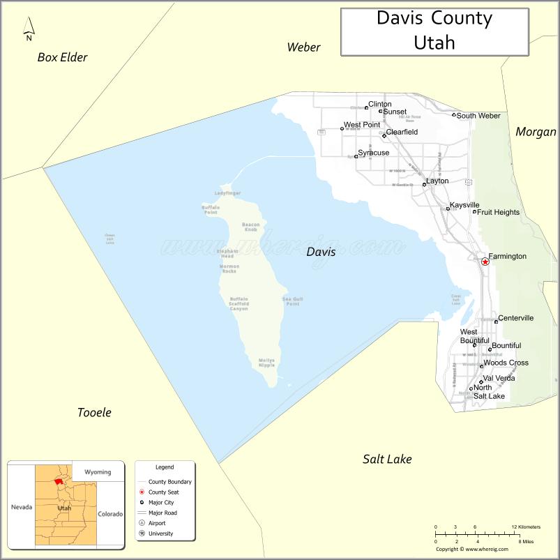
About Davis County Map, Utah: The map showing the county boundary, county seat, major cities, and neighbouring counties.
Most Viewed Links
| Utah Map | Counties in Utah | Cities in Utah |
| Utah Zipcodes | Airports in Utah | US Zip code Map |
| Utah Area Codes | Utah River Map | - |
About Davis County, Utah
Davis County is a county located in the U.S. state of Utah. Its county seat is Farmington. As per the 2020 census, the population of Davis County is 367,285 people, and the population density is approximately 1,229 people per square mile. According to the United States Census Bureau, the county has a total area of 299 sq mi (774 km²). Davis County was established on October 5, 1850.
Davis County Facts
| Category | Details |
|---|---|
| County Name | Davis County |
| State | Utah |
| Country | United States |
| Region | Northern Utah |
| County Seat | Farmington |
| Established | 1852 |
| Total Area | 634 sq mi (1,642 sq km) |
| Land Area | 299 sq mi |
| Water Area | 335 sq mi |
| Population (2020) | 362,679 |
| Population Density | ~1,213 persons per sq mi (land area) |
| Time Zone | Mountain Time Zone (MT) |
| Area Code | 385, 801 |
| Nearest Airport | Salt Lake City International Airport |
| Famous For | Antelope Island, Great Salt Lake, suburban communities |
| Tourist Places | Antelope Island State Park, Great Salt Lake Shorelands Preserve, Lagoon Amusement Park |
| Nearby Cities | Salt Lake City, UT; Layton, UT; Bountiful, UT |
| FIPS Code | 49-011 |
| Official Website | daviscountyutah.gov |
Cities and Towns in Davis County, Utah
| City/Town | Population (2020) |
|---|---|
| Layton | 81,773 |
| Bountiful | 45,762 |
| Kaysville | 32,945 |
| Clearfield | 31,909 |
| Syracuse | 30,780 |
| Farmington | 24,531 |
| Clinton | 23,360 |
| Centerville | 16,960 |
| North Salt Lake | 20,948 |
| Woods Cross | 11,431 |
| West Bountiful | 5,272 |
| Sunset | 5,431 |
| South Weber | 8,075 |
| Fruit Heights | 6,426 |
Top Places to Visit in Davis County, Utah
| Place | Description |
|---|---|
| Antelope Island State Park | A scenic island in the Great Salt Lake known for bison, wide views, and peaceful hiking trails. |
| Lagoon Amusement Park | A popular theme park with roller coasters, rides, and fun attractions for all ages. |
| Great Salt Lake Shorelands Preserve | A quiet nature area with walking trails and great birdwatching spots. |
| Farmington Bay Wildlife Management Area | A calm wetland area where you can spot birds and enjoy peaceful surroundings. |
| Hill Aerospace Museum | A fascinating museum with aircraft displays and stories from aviation history. |
| Cherry Hill Water Park | A family-friendly spot with water slides, pools, and relaxing picnic areas. |
| Mueller Park Trail | A popular hiking trail with shaded paths and nice views of the surrounding hills. |
| Centerville Canyon | A quiet canyon area with trails, picnic spots, and a peaceful natural setting. |
| Layton Commons Park | A local park with open green space, playgrounds, and a relaxed atmosphere. |
| Station Park | A modern outdoor shopping and dining area with a lively and welcoming feel. |
- Beaver County Map
- Box Elder County Map
- Cache County Map
- Carbon County Map
- Daggett County Map
- Davis County Map
- Duchesne County Map
- Emery County Map
- Garfield County Map
- Grand County Map
- Iron County Map
- Juab County Map
- Kane County Map
- Millard County Map
- Morgan County Map
- Piute County Map
- Rich County Map
- Salt Lake County Map
- San Juan County Map
- Sanpete County Map
- Sevier County Map
- Summit County Map
- Tooele County Map
- Uintah County Map
- Utah County Map
- Wasatch County Map
- Washington County Map
- Wayne County Map
- Weber County Map
- Alabama Counties
- Alaska boroughs
- Arizona Counties
- Arkansas Counties
- California County Map
- Colorado Counties
- Connecticut Counties
- Delaware Counties
- Florida County Map
- Georgia County Map
- Hawaii Counties
- Idaho Counties
- Illinois Counties
- Indiana Counties
- Iowa Counties
- Kansas Counties
- Kentucky Counties
- Louisiana Counties
- Maine Counties
- Maryland Counties
- Massachusetts Counties
- Michigan County Map
- Minnesota Counties
- Mississippi Counties
- Missouri Counties
- Montana Counties
- Nebraska Counties
- Nevada Counties
- New York Counties
- New Hampshire Counties
- New Jersey Counties
- New Mexico Counties
- North Carolina Counties
- North Dakota Counties
- Ohio County Map
- Oklahoma Counties
- Oregon Counties
- Pennsylvania Counties
- Rhode Island Counties
- South Carolina Counties
- South Dakota Counties
- Map of Tennessee
- Texas County Map
- Utah Counties
- Vermont Counties
- Virginia Counties
- Washington Counties
- West Virginia Counties
- Wisconsin Counties
- Wyoming Counties