Map of Sanpete County - Sanpete County is a county located in the U.S. state of Utah. Sanpete County Map showing cities, highways, important places and water bodies. Get Where is Sanpete County located in the map, major cities in Sanpete county, population, areas, and places of interest.
Map of Sanpete County, Utah
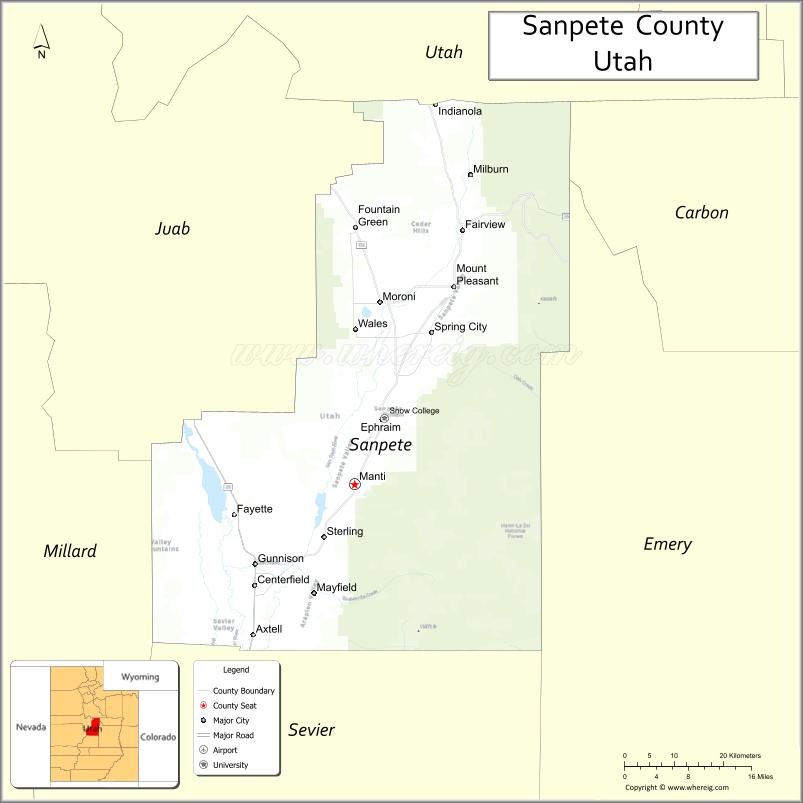
About Sanpete County Map, Utah: The map showing the county boundary, county seat, major cities, and neighbouring counties.
Most Viewed Links
| Utah Map | Counties in Utah | Cities in Utah |
| Utah Zipcodes | Airports in Utah | US Zip code Map |
| Utah Area Codes | Utah River Map | - |
About Sanpete County, Utah
Sanpete County is a county located in the U.S. state of Utah. Its county seat is Manti. As per the 2020 census, the population of Sanpete County is 29,106 people, and the population density is approximately 18.3 people per square mile. According to the United States Census Bureau, the county has a total area of 1,590 sq mi (4,118 km²). Sanpete County was established on January 31, 1850.
Sanpete County Facts
| Category | Details |
|---|---|
| County Name | Sanpete County |
| State | Utah |
| Country | United States |
| Region | Central Utah |
| County Seat | Manti |
| Established | 1850 |
| Total Area | 1,603 sq mi (4,151 sq km) |
| Land Area | 1,590 sq mi |
| Water Area | 13 sq mi |
| Population (2020) | 28,437 |
| Population Density | ~18 persons per sq mi |
| Time Zone | Mountain Time Zone (MT) |
| Area Code | 435 |
| Nearest Airport | Provo Municipal Airport |
| Famous For | Swiss heritage, agriculture, Manti Temple |
| Tourist Places | Manti-La Sal National Forest, Palisade State Park, Manti Temple |
| Nearby Cities | Ephraim, UT; Manti, UT; Mount Pleasant, UT |
| FIPS Code | 49-039 |
| Official Website | sanpetecounty.org |
Cities and Towns in Sanpete County, Utah
| City/Town | Population (2020) |
|---|---|
| Manti | 3,276 |
| Ephraim | 6,135 |
| Gunnison | 3,452 |
| Mount Pleasant | 3,655 |
| Spring City | 1,026 |
| Moroni | 1,491 |
| Fountain Green | 1,071 |
| Wales | 302 |
| Mayfield | 498 |
| Fairview | 1,285 |
| Centerfield | 1,367 |
| Axtell | 329 |
| Redmond | 972 |
Top Places to Visit in Sanpete County, Utah
| Place | Description |
|---|---|
| Palisade State Park | A peaceful park with a small lake, perfect for fishing, golfing, and relaxing. |
| Manti-La Sal National Forest | A scenic forest area with trails, mountain views, and cool, fresh air. |
| Manti Temple | A beautiful historic building set on a hill, offering great views of the town. |
| Sanpete Valley | A wide valley with open landscapes, farms, and a quiet rural feel. |
| Fairview Canyon | A scenic canyon drive with winding roads and stunning mountain views. |
| Skyline Drive | A high mountain road with sweeping views, especially popular in summer and fall. |
| Gunnison Reservoir | A calm water spot for fishing, boating, and enjoying the outdoors. |
| Snow College | A small college campus with a friendly atmosphere and local charm. |
| Moroni City Park | A simple park with green space and a relaxing place to take a break. |
| Six Mile Canyon | A quiet canyon with scenic views and a peaceful drive. |
- Beaver County Map
- Box Elder County Map
- Cache County Map
- Carbon County Map
- Daggett County Map
- Davis County Map
- Duchesne County Map
- Emery County Map
- Garfield County Map
- Grand County Map
- Iron County Map
- Juab County Map
- Kane County Map
- Millard County Map
- Morgan County Map
- Piute County Map
- Rich County Map
- Salt Lake County Map
- San Juan County Map
- Sanpete County Map
- Sevier County Map
- Summit County Map
- Tooele County Map
- Uintah County Map
- Utah County Map
- Wasatch County Map
- Washington County Map
- Wayne County Map
- Weber County Map
- Alabama Counties
- Alaska boroughs
- Arizona Counties
- Arkansas Counties
- California County Map
- Colorado Counties
- Connecticut Counties
- Delaware Counties
- Florida County Map
- Georgia County Map
- Hawaii Counties
- Idaho Counties
- Illinois Counties
- Indiana Counties
- Iowa Counties
- Kansas Counties
- Kentucky Counties
- Louisiana Counties
- Maine Counties
- Maryland Counties
- Massachusetts Counties
- Michigan County Map
- Minnesota Counties
- Mississippi Counties
- Missouri Counties
- Montana Counties
- Nebraska Counties
- Nevada Counties
- New York Counties
- New Hampshire Counties
- New Jersey Counties
- New Mexico Counties
- North Carolina Counties
- North Dakota Counties
- Ohio County Map
- Oklahoma Counties
- Oregon Counties
- Pennsylvania Counties
- Rhode Island Counties
- South Carolina Counties
- South Dakota Counties
- Map of Tennessee
- Texas County Map
- Utah Counties
- Vermont Counties
- Virginia Counties
- Washington Counties
- West Virginia Counties
- Wisconsin Counties
- Wyoming Counties