Map of Piute County - Piute County is a county located in the U.S. state of Utah. Piute County Map showing cities, highways, important places and water bodies. Get Where is Piute County located in the map, major cities in Piute county, population, areas, and places of interest.
Map of Piute County, Utah
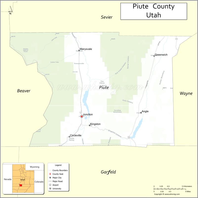
About Piute County Map, Utah: The map showing the county boundary, county seat, major cities, and neighbouring counties.
Most Viewed Links
| Utah Map | Counties in Utah | Cities in Utah |
| Utah Zipcodes | Airports in Utah | US Zip code Map |
| Utah Area Codes | Utah River Map | - |
About Piute County, Utah
Piute County is a county located in the U.S. state of Utah. Its county seat is Junction. As per the 2020 census, the population of Piute County is 1,487 people, and the population density is approximately 2.0 people per square mile. According to the United States Census Bureau, the county has a total area of 758 sq mi (1,963 km²). Piute County was established on January 16, 1865.
Piute County Facts
| Category | Details |
|---|---|
| County Name | Piute County |
| State | Utah |
| Country | United States |
| Region | Central Utah |
| County Seat | Junction |
| Established | 1865 |
| Total Area | 766 sq mi (1,984 sq km) |
| Land Area | 758 sq mi |
| Water Area | 8 sq mi |
| Population (2020) | 1,438 |
| Population Density | ~2 persons per sq mi |
| Time Zone | Mountain Time Zone (MT) |
| Area Code | 435 |
| Nearest Airport | Richfield Municipal Airport |
| Famous For | Otter Creek Reservoir, fishing, rural landscapes |
| Tourist Places | Otter Creek State Park, Piute Reservoir, Fishlake National Forest |
| Nearby Cities | Richfield, UT; Circleville, UT; Marysvale, UT |
| FIPS Code | 49-031 |
| Official Website | piute.utah.gov |
Cities and Towns in Piute County, Utah
| City/Town | Population (2020) |
|---|---|
| Junction | 191 |
| Circleville | 568 |
Top Places to Visit in Piute County, Utah
| Place | Description |
|---|---|
| Otter Creek State Park | A quiet reservoir area great for fishing, boating, and relaxing by the water. |
| Fishlake National Forest | A peaceful forest with cool air, scenic drives, and plenty of spots to unwind. |
| Tushar Mountains | A beautiful mountain range with hiking trails, lakes, and wide views. |
| Circleville Canyon | A scenic canyon drive with red rock cliffs and open landscapes. |
| Piute Reservoir | A calm lake area perfect for fishing and enjoying a quiet day outdoors. |
| Mount Belknap | A high mountain area offering great views and a remote feel. |
| Marysvale | A small town known for outdoor trails and access to nearby mountains. |
| Bullion Canyon | A historic mining area with trails and interesting remnants from the past. |
| Kingston Canyon | A peaceful canyon with scenic views and a relaxing atmosphere. |
| Piute County Courthouse | A small historic building that reflects the county’s local heritage. |
- Beaver County Map
- Box Elder County Map
- Cache County Map
- Carbon County Map
- Daggett County Map
- Davis County Map
- Duchesne County Map
- Emery County Map
- Garfield County Map
- Grand County Map
- Iron County Map
- Juab County Map
- Kane County Map
- Millard County Map
- Morgan County Map
- Piute County Map
- Rich County Map
- Salt Lake County Map
- San Juan County Map
- Sanpete County Map
- Sevier County Map
- Summit County Map
- Tooele County Map
- Uintah County Map
- Utah County Map
- Wasatch County Map
- Washington County Map
- Wayne County Map
- Weber County Map
- Alabama Counties
- Alaska boroughs
- Arizona Counties
- Arkansas Counties
- California County Map
- Colorado Counties
- Connecticut Counties
- Delaware Counties
- Florida County Map
- Georgia County Map
- Hawaii Counties
- Idaho Counties
- Illinois Counties
- Indiana Counties
- Iowa Counties
- Kansas Counties
- Kentucky Counties
- Louisiana Counties
- Maine Counties
- Maryland Counties
- Massachusetts Counties
- Michigan County Map
- Minnesota Counties
- Mississippi Counties
- Missouri Counties
- Montana Counties
- Nebraska Counties
- Nevada Counties
- New York Counties
- New Hampshire Counties
- New Jersey Counties
- New Mexico Counties
- North Carolina Counties
- North Dakota Counties
- Ohio County Map
- Oklahoma Counties
- Oregon Counties
- Pennsylvania Counties
- Rhode Island Counties
- South Carolina Counties
- South Dakota Counties
- Map of Tennessee
- Texas County Map
- Utah Counties
- Vermont Counties
- Virginia Counties
- Washington Counties
- West Virginia Counties
- Wisconsin Counties
- Wyoming Counties