Map of San Juan County - San Juan County is a county located in the U.S. state of Utah. San Juan County Map showing cities, highways, important places and water bodies. Get Where is San Juan County located in the map, major cities in San Juan county, population, areas, and places of interest.
Map of San Juan County, Utah
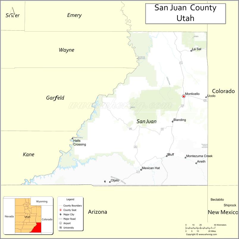
About San Juan County Map, Utah: The map showing the county boundary, county seat, major cities, and neighbouring counties.
Most Viewed Links
| Utah Map | Counties in Utah | Cities in Utah |
| Utah Zipcodes | Airports in Utah | US Zip code Map |
| Utah Area Codes | Utah River Map | - |
About San Juan County, Utah
San Juan County is a county located in the U.S. state of Utah. Its county seat is Monticello. As per the 2020 census, the population of San Juan County is 14,489 people, and the population density is approximately 1.9 people per square mile. According to the United States Census Bureau, the county has a total area of 7,820 sq mi (20,254 km²). San Juan County was established on February 17, 1880.
San Juan County Facts
| Category | Details |
|---|---|
| County Name | San Juan County |
| State | Utah |
| Country | United States |
| Region | Southeastern Utah |
| County Seat | Monticello |
| Established | 1880 |
| Total Area | 7,933 sq mi (20,547 sq km) |
| Land Area | 7,820 sq mi |
| Water Area | 113 sq mi |
| Population (2020) | 14,518 |
| Population Density | ~2 persons per sq mi |
| Time Zone | Mountain Time Zone (MT) |
| Area Code | 435 |
| Nearest Airport | Cortez Municipal Airport |
| Famous For | Monument Valley, Navajo Nation, Canyonlands landscapes |
| Tourist Places | Monument Valley, Natural Bridges National Monument, Canyonlands National Park |
| Nearby Cities | Moab, UT; Cortez, CO; Monticello, UT |
| FIPS Code | 49-037 |
| Official Website | sanjuancountyutah.org |
Cities and Towns in San Juan County, Utah
| City/Town | Population (2020) |
|---|---|
| Monticello | 1,972 |
| Blanding | 3,346 |
| Bluff | 287 |
Top Places to Visit in San Juan County, Utah
| Place | Description |
|---|---|
| Monument Valley | A famous desert landscape with towering red rock formations and iconic views. |
| Canyonlands National Park (Needles District) | A rugged area with colorful rock formations and great hiking trails. |
| Natural Bridges National Monument | A scenic park known for its large natural stone bridges and quiet setting. |
| Goosenecks State Park | A dramatic viewpoint where the river curves through deep canyon bends. |
| Valley of the Gods | A peaceful area with towering rock formations and a scenic drive. |
| Moki Dugway | A steep and winding dirt road with incredible views along the way. |
| Hovenweep National Monument | A historic site with ancient stone towers and a remote feel. |
| Lake Powell (part) | A large lake with blue water and red rock surroundings, great for boating. |
| Blanding | A small town that serves as a base for exploring nearby attractions. |
| Edge of the Cedars State Park | A cultural site with ruins and artifacts from ancient Native American life. |
- Beaver County Map
- Box Elder County Map
- Cache County Map
- Carbon County Map
- Daggett County Map
- Davis County Map
- Duchesne County Map
- Emery County Map
- Garfield County Map
- Grand County Map
- Iron County Map
- Juab County Map
- Kane County Map
- Millard County Map
- Morgan County Map
- Piute County Map
- Rich County Map
- Salt Lake County Map
- San Juan County Map
- Sanpete County Map
- Sevier County Map
- Summit County Map
- Tooele County Map
- Uintah County Map
- Utah County Map
- Wasatch County Map
- Washington County Map
- Wayne County Map
- Weber County Map
- Alabama Counties
- Alaska boroughs
- Arizona Counties
- Arkansas Counties
- California County Map
- Colorado Counties
- Connecticut Counties
- Delaware Counties
- Florida County Map
- Georgia County Map
- Hawaii Counties
- Idaho Counties
- Illinois Counties
- Indiana Counties
- Iowa Counties
- Kansas Counties
- Kentucky Counties
- Louisiana Counties
- Maine Counties
- Maryland Counties
- Massachusetts Counties
- Michigan County Map
- Minnesota Counties
- Mississippi Counties
- Missouri Counties
- Montana Counties
- Nebraska Counties
- Nevada Counties
- New York Counties
- New Hampshire Counties
- New Jersey Counties
- New Mexico Counties
- North Carolina Counties
- North Dakota Counties
- Ohio County Map
- Oklahoma Counties
- Oregon Counties
- Pennsylvania Counties
- Rhode Island Counties
- South Carolina Counties
- South Dakota Counties
- Map of Tennessee
- Texas County Map
- Utah Counties
- Vermont Counties
- Virginia Counties
- Washington Counties
- West Virginia Counties
- Wisconsin Counties
- Wyoming Counties