Map of Carbon County - Carbon County is a county located in the U.S. state of Utah. Carbon County Map showing cities, highways, important places and water bodies. Get Where is Carbon County located in the map, major cities in Carbon county, population, areas, and places of interest.
Map of Carbon County, Utah
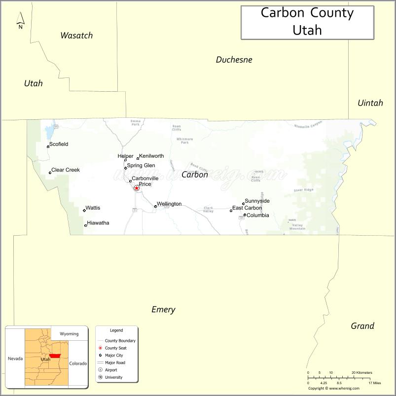
About Carbon County Map, Utah: The map showing the county boundary, county seat, major cities, and neighbouring counties.
Most Viewed Links
| Utah Map | Counties in Utah | Cities in Utah |
| Utah Zipcodes | Airports in Utah | US Zip code Map |
| Utah Area Codes | Utah River Map | - |
About Carbon County, Utah
Carbon County is a county located in the U.S. state of Utah. Its county seat is Price. As per the 2020 census, the population of Carbon County is 20,372 people, and the population density is approximately 13.8 people per square mile. According to the United States Census Bureau, the county has a total area of 1,478 sq mi (3,828 km²). Carbon County was established on March 8, 1894.
Carbon County Facts
| Category | Details |
|---|---|
| County Name | Carbon County |
| State | Utah |
| Country | United States |
| Region | Eastern Utah |
| County Seat | Price |
| Established | 1894 |
| Total Area | 1,485 sq mi (3,846 sq km) |
| Land Area | 1,478 sq mi |
| Water Area | 7 sq mi |
| Population (2020) | 20,412 |
| Population Density | ~14 persons per sq mi |
| Time Zone | Mountain Time Zone (MT) |
| Area Code | 435 |
| Nearest Airport | Carbon County Regional Airport |
| Famous For | Coal mining, dinosaur fossils, energy production |
| Tourist Places | Utah State University Eastern Prehistoric Museum, Nine Mile Canyon, Scofield State Park |
| Nearby Cities | Price, UT; Helper, UT; Wellington, UT |
| FIPS Code | 49-007 |
| Official Website | carbon.utah.gov |
Cities and Towns in Carbon County, Utah
| City/Town | Population (2020) |
|---|---|
| Price | 8,715 |
| Helper | 2,201 |
| Wellington | 1,702 |
| East Carbon | 1,301 |
| Sunnyside | 310 |
| Scofield | 23 |
Top Places to Visit in Carbon County, Utah
| Place | Description |
|---|---|
| Nine Mile Canyon | A scenic canyon known for its ancient rock art and long, quiet drive through history. |
| Helper Historic District | A charming old town area with colorful buildings, art galleries, and a relaxed vibe. |
| Western Mining and Railroad Museum | A small museum that shares the area's mining history with interesting exhibits. |
| Price Canyon Recreation Area | A peaceful canyon spot with picnic areas, trails, and nice views. |
| Carbon Country Club | A golf course with open views and a laid-back setting for a relaxing round. |
| Scofield State Park | A mountain lake area perfect for fishing, boating, and camping. |
| Electric Lake | A quiet lake surrounded by hills, great for fishing and enjoying the outdoors. |
| Wellington City Park | A simple local park with green space, playgrounds, and picnic spots. |
| Desert Wave Pool | A fun spot in Price with water slides and wave pools, great for families. |
| Book Cliffs | A rugged landscape with wide views, popular for outdoor exploring and wildlife spotting. |
- Beaver County Map
- Box Elder County Map
- Cache County Map
- Carbon County Map
- Daggett County Map
- Davis County Map
- Duchesne County Map
- Emery County Map
- Garfield County Map
- Grand County Map
- Iron County Map
- Juab County Map
- Kane County Map
- Millard County Map
- Morgan County Map
- Piute County Map
- Rich County Map
- Salt Lake County Map
- San Juan County Map
- Sanpete County Map
- Sevier County Map
- Summit County Map
- Tooele County Map
- Uintah County Map
- Utah County Map
- Wasatch County Map
- Washington County Map
- Wayne County Map
- Weber County Map
- Alabama Counties
- Alaska boroughs
- Arizona Counties
- Arkansas Counties
- California County Map
- Colorado Counties
- Connecticut Counties
- Delaware Counties
- Florida County Map
- Georgia County Map
- Hawaii Counties
- Idaho Counties
- Illinois Counties
- Indiana Counties
- Iowa Counties
- Kansas Counties
- Kentucky Counties
- Louisiana Counties
- Maine Counties
- Maryland Counties
- Massachusetts Counties
- Michigan County Map
- Minnesota Counties
- Mississippi Counties
- Missouri Counties
- Montana Counties
- Nebraska Counties
- Nevada Counties
- New York Counties
- New Hampshire Counties
- New Jersey Counties
- New Mexico Counties
- North Carolina Counties
- North Dakota Counties
- Ohio County Map
- Oklahoma Counties
- Oregon Counties
- Pennsylvania Counties
- Rhode Island Counties
- South Carolina Counties
- South Dakota Counties
- Map of Tennessee
- Texas County Map
- Utah Counties
- Vermont Counties
- Virginia Counties
- Washington Counties
- West Virginia Counties
- Wisconsin Counties
- Wyoming Counties