Map of Duchesne County - Duchesne County is a county located in the U.S. state of Utah. Duchesne County Map showing cities, highways, important places and water bodies. Get Where is Duchesne County located in the map, major cities in Duchesne county, population, areas, and places of interest.
Map of Duchesne County, Utah
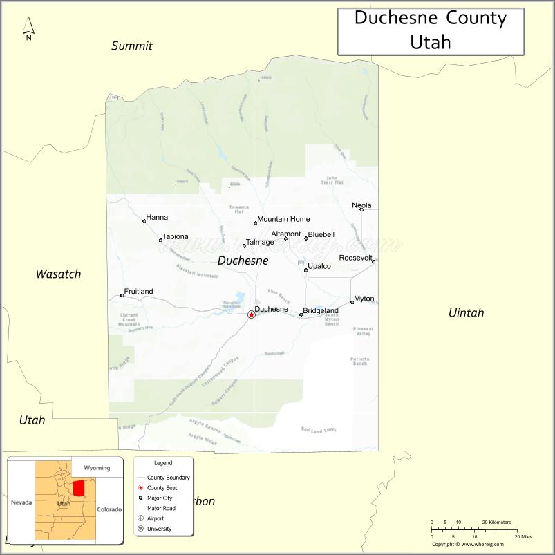
About Duchesne County Map, Utah: The map showing the county boundary, county seat, major cities, and neighbouring counties.
Most Viewed Links
| Utah Map | Counties in Utah | Cities in Utah |
| Utah Zipcodes | Airports in Utah | US Zip code Map |
| Utah Area Codes | Utah River Map | - |
About Duchesne County, Utah
Duchesne County is a county located in the U.S. state of Utah. Its county seat is Duchesne. As per the 2020 census, the population of Duchesne County is 19,790 people, and the population density is approximately 6.1 people per square mile. According to the United States Census Bureau, the county has a total area of 3,241 sq mi (8,394 km²). Duchesne County was established on July 3, 1915.
Duchesne County Facts
| Category | Details |
|---|---|
| County Name | Duchesne County |
| State | Utah |
| Country | United States |
| Region | Northeastern Utah |
| County Seat | Duchesne |
| Established | 1915 |
| Total Area | 3,256 sq mi (8,433 sq km) |
| Land Area | 3,241 sq mi |
| Water Area | 15 sq mi |
| Population (2020) | 19,596 |
| Population Density | ~6 persons per sq mi |
| Time Zone | Mountain Time Zone (MT) |
| Area Code | 435 |
| Nearest Airport | Vernal Regional Airport |
| Famous For | Uinta Mountains, oil and gas production, outdoor recreation |
| Tourist Places | Starvation State Park, Uinta Mountains, Strawberry Reservoir |
| Nearby Cities | Vernal, UT; Roosevelt, UT; Duchesne, UT |
| FIPS Code | 49-013 |
| Official Website | duchesne.utah.gov |
Cities and Towns in Duchesne County, Utah
| City/Town | Population (2020) |
|---|---|
| Duchesne | 1,633 |
| Roosevelt | 7,070 |
| Myton | 600 |
Top Places to Visit in Duchesne County, Utah
| Place | Description |
|---|---|
| Strawberry Reservoir | A large, scenic lake known for great fishing, boating, and peaceful mountain views. |
| Starvation State Park | A quiet spot with a reservoir perfect for fishing, camping, and relaxing by the water. |
| Uinta-Wasatch-Cache National Forest | A beautiful forest area with trails, wildlife, and cool mountain air. |
| High Uintas Wilderness | A remote wilderness with alpine lakes, rugged peaks, and excellent hiking opportunities. |
| Duchesne River | A calm river that flows through the county, great for fishing and enjoying nature. |
| Tabiona Mountains | A quiet mountain area with open views and peaceful outdoor spaces. |
| Red Fleet State Park | A scenic reservoir with red rock surroundings, known for boating and dinosaur tracks nearby. |
| Indian Canyon Scenic Byway | A relaxing drive through forested hills and open landscapes with beautiful views. |
| Blue Mountain | A remote and rugged area offering wide views and a true backcountry feel. |
| Duchesne City Park | A simple local park with green space, perfect for a quiet break. |
- Beaver County Map
- Box Elder County Map
- Cache County Map
- Carbon County Map
- Daggett County Map
- Davis County Map
- Duchesne County Map
- Emery County Map
- Garfield County Map
- Grand County Map
- Iron County Map
- Juab County Map
- Kane County Map
- Millard County Map
- Morgan County Map
- Piute County Map
- Rich County Map
- Salt Lake County Map
- San Juan County Map
- Sanpete County Map
- Sevier County Map
- Summit County Map
- Tooele County Map
- Uintah County Map
- Utah County Map
- Wasatch County Map
- Washington County Map
- Wayne County Map
- Weber County Map
- Alabama Counties
- Alaska boroughs
- Arizona Counties
- Arkansas Counties
- California County Map
- Colorado Counties
- Connecticut Counties
- Delaware Counties
- Florida County Map
- Georgia County Map
- Hawaii Counties
- Idaho Counties
- Illinois Counties
- Indiana Counties
- Iowa Counties
- Kansas Counties
- Kentucky Counties
- Louisiana Counties
- Maine Counties
- Maryland Counties
- Massachusetts Counties
- Michigan County Map
- Minnesota Counties
- Mississippi Counties
- Missouri Counties
- Montana Counties
- Nebraska Counties
- Nevada Counties
- New York Counties
- New Hampshire Counties
- New Jersey Counties
- New Mexico Counties
- North Carolina Counties
- North Dakota Counties
- Ohio County Map
- Oklahoma Counties
- Oregon Counties
- Pennsylvania Counties
- Rhode Island Counties
- South Carolina Counties
- South Dakota Counties
- Map of Tennessee
- Texas County Map
- Utah Counties
- Vermont Counties
- Virginia Counties
- Washington Counties
- West Virginia Counties
- Wisconsin Counties
- Wyoming Counties