Map of Sevier County - Sevier County is a county located in the U.S. state of Utah. Sevier County Map showing cities, highways, important places and water bodies. Get Where is Sevier County located in the map, major cities in Sevier county, population, areas, and places of interest.
Map of Sevier County, Utah
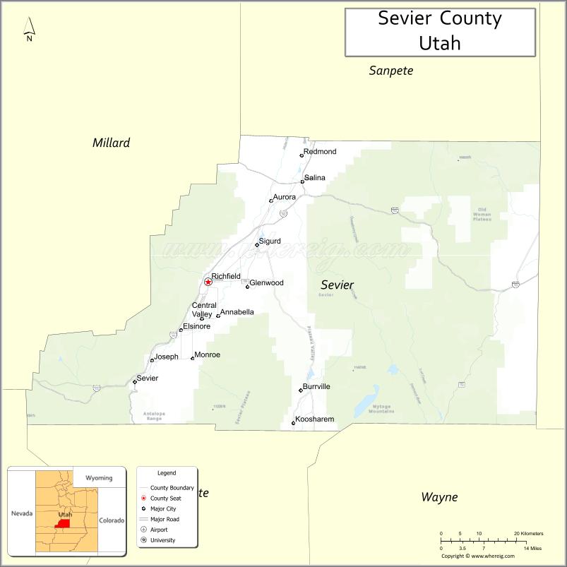
About Sevier County Map, Utah: The map showing the county boundary, county seat, major cities, and neighbouring counties.
Most Viewed Links
| Utah Map | Counties in Utah | Cities in Utah |
| Utah Zipcodes | Airports in Utah | US Zip code Map |
| Utah Area Codes | Utah River Map | - |
About Sevier County, Utah
Sevier County is a county located in the U.S. state of Utah. Its county seat is Richfield. As per the 2020 census, the population of Sevier County is 21,906 people, and the population density is approximately 11.5 people per square mile. According to the United States Census Bureau, the county has a total area of 1,911 sq mi (4,949 km²). Sevier County was established on January 16, 1865.
Sevier County Facts
| Category | Details |
|---|---|
| County Name | Sevier County |
| State | Utah |
| Country | United States |
| Region | Central Utah |
| County Seat | Richfield |
| Established | 1865 |
| Total Area | 1,918 sq mi (4,968 sq km) |
| Land Area | 1,911 sq mi |
| Water Area | 7 sq mi |
| Population (2020) | 21,522 |
| Population Density | ~11 persons per sq mi |
| Time Zone | Mountain Time Zone (MT) |
| Area Code | 435 |
| Nearest Airport | Richfield Municipal Airport |
| Famous For | Agriculture, central Utah hub, scenic valleys |
| Tourist Places | Fishlake National Forest, Fremont Indian State Park, Cove Fort |
| Nearby Cities | Salina, UT; Monroe, UT; Richfield, UT |
| FIPS Code | 49-041 |
| Official Website | sevierutah.net |
Cities and Towns in Sevier County, Utah
| City/Town | Population (2020) |
|---|---|
| Richfield | 8,154 |
| Salina | 2,591 |
| Monroe | 2,051 |
| Aurora | 1,048 |
| Elsinore | 847 |
| Annabella | 795 |
| Redmond | 1,034 |
| Central Valley | 555 |
Top Places to Visit in Sevier County, Utah
| Place | Description |
|---|---|
| Fishlake National Forest | A peaceful forest with lakes, trails, and plenty of space to relax outdoors. |
| Fish Lake | A large mountain lake known for fishing, boating, and calm scenic views. |
| Fremont Indian State Park | A fascinating site with ancient artifacts and rock art from early Native cultures. |
| Monroe Hot Springs | A natural hot spring area perfect for a warm and relaxing soak. |
| Big Rock Candy Mountain | A colorful rock formation made famous by the old folk song. |
| Richfield City Park | A nice local park with green space, walking paths, and a laid-back feel. |
| Sevier River | A calm river that flows through the county, great for fishing and quiet moments. |
| Red Hill | A small but scenic hill offering nice views over the surrounding area. |
| Clear Creek Canyon | A quiet canyon with rugged views and a peaceful atmosphere. |
| Aurora Reservoir | A simple lake spot ideal for fishing and enjoying a calm day outdoors. |
- Beaver County Map
- Box Elder County Map
- Cache County Map
- Carbon County Map
- Daggett County Map
- Davis County Map
- Duchesne County Map
- Emery County Map
- Garfield County Map
- Grand County Map
- Iron County Map
- Juab County Map
- Kane County Map
- Millard County Map
- Morgan County Map
- Piute County Map
- Rich County Map
- Salt Lake County Map
- San Juan County Map
- Sanpete County Map
- Sevier County Map
- Summit County Map
- Tooele County Map
- Uintah County Map
- Utah County Map
- Wasatch County Map
- Washington County Map
- Wayne County Map
- Weber County Map
- Alabama Counties
- Alaska boroughs
- Arizona Counties
- Arkansas Counties
- California County Map
- Colorado Counties
- Connecticut Counties
- Delaware Counties
- Florida County Map
- Georgia County Map
- Hawaii Counties
- Idaho Counties
- Illinois Counties
- Indiana Counties
- Iowa Counties
- Kansas Counties
- Kentucky Counties
- Louisiana Counties
- Maine Counties
- Maryland Counties
- Massachusetts Counties
- Michigan County Map
- Minnesota Counties
- Mississippi Counties
- Missouri Counties
- Montana Counties
- Nebraska Counties
- Nevada Counties
- New York Counties
- New Hampshire Counties
- New Jersey Counties
- New Mexico Counties
- North Carolina Counties
- North Dakota Counties
- Ohio County Map
- Oklahoma Counties
- Oregon Counties
- Pennsylvania Counties
- Rhode Island Counties
- South Carolina Counties
- South Dakota Counties
- Map of Tennessee
- Texas County Map
- Utah Counties
- Vermont Counties
- Virginia Counties
- Washington Counties
- West Virginia Counties
- Wisconsin Counties
- Wyoming Counties