Map of Utah County - Utah County is a county located in the U.S. state of Utah. Utah County Map showing cities, highways, important places and water bodies. Get Where is Utah County located in the map, major cities in Utah county, population, areas, and places of interest.
Map of Utah County, Utah
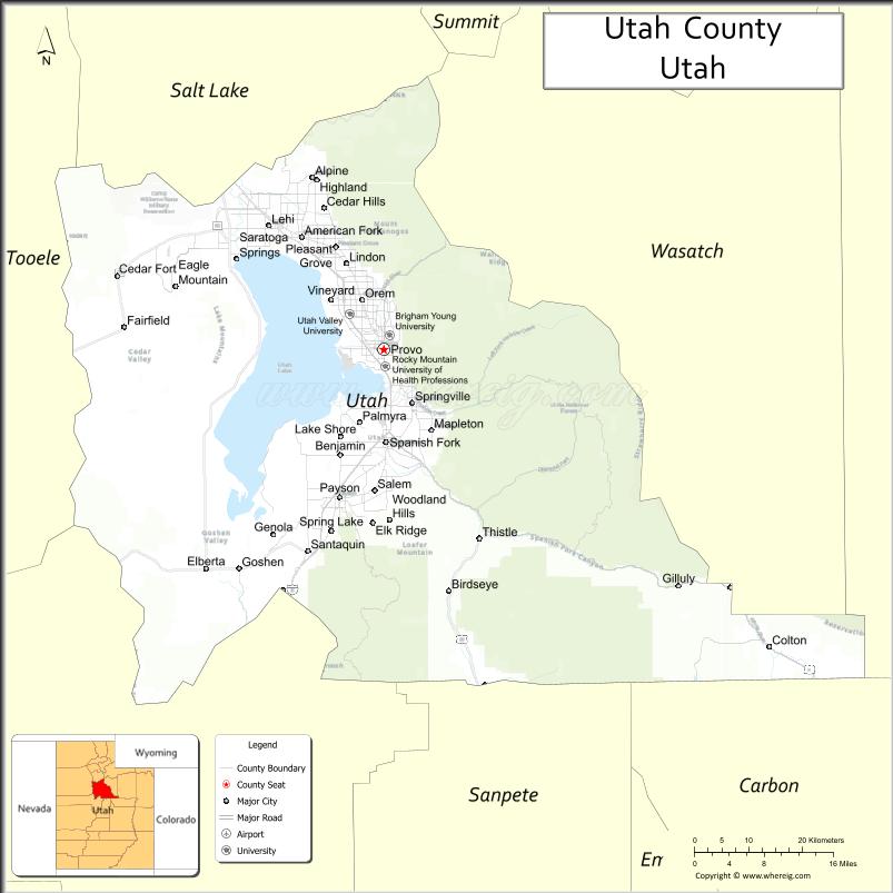
About Utah County Map, Utah: The map showing the county boundary, county seat, major cities, and neighbouring counties.
Most Viewed Links
| Utah Map | Counties in Utah | Cities in Utah |
| Utah Zipcodes | Airports in Utah | US Zip code Map |
| Utah Area Codes | Utah River Map | - |
About Utah County, Utah
Utah County is a county located in the U.S. state of Utah. Its county seat is Provo. As per the 2020 census, the population of Utah County is 684,986 people, and the population density is approximately 342 people per square mile. According to the United States Census Bureau, the county has a total area of 2,003 sq mi (5,188 km²). Utah County was established on January 31, 1850.
Utah County Facts
| Category | Details |
|---|---|
| County Name | Utah County |
| State | Utah |
| Country | United States |
| Region | North-central Utah |
| County Seat | Provo |
| Established | 1850 |
| Total Area | 2,144 sq mi (5,552 sq km) |
| Land Area | 2,003 sq mi |
| Water Area | 141 sq mi |
| Population (2020) | 659,399 |
| Population Density | ~329 persons per sq mi |
| Time Zone | Mountain Time Zone (MT) |
| Area Code | 385, 801 |
| Nearest Airport | Provo Municipal Airport |
| Famous For | Brigham Young University, Utah Lake, tech industry growth |
| Tourist Places | Utah Lake, Bridal Veil Falls, Sundance Mountain Resort |
| Nearby Cities | Orem, UT; Provo, UT; Lehi, UT |
| FIPS Code | 49-049 |
| Official Website | utahcounty.gov |
Cities and Towns in Utah County, Utah
| City/Town | Population (2020) |
|---|---|
| Provo | 115,162 |
| Orem | 98,129 |
| Lehi | 75,907 |
| Spanish Fork | 42,602 |
| Pleasant Grove | 37,845 |
| American Fork | 33,337 |
| Payson | 21,101 |
| Springville | 35,268 |
| Lindon | 11,785 |
| Mapleton | 11,489 |
| Santaquin | 13,911 |
| Saratoga Springs | 37,248 |
| Alpine | 10,251 |
| Cedar Hills | 10,315 |
| Elk Ridge | 4,469 |
| Woodland Hills | 1,801 |
| Salem | 9,298 |
| Genola | 1,610 |
| Goshen | 1,019 |
Top Places to Visit in Utah County, Utah
| Place | Description |
|---|---|
| Utah Lake | A large freshwater lake perfect for boating, fishing, and relaxing by the water. |
| Provo Canyon | A scenic canyon with waterfalls, trails, and beautiful mountain views. |
| Bridal Veil Falls | A stunning waterfall that’s easy to reach and great for photos. |
| Brigham Young University | A lively campus with green spaces, museums, and a welcoming feel. |
| Timpanogos Cave National Monument | A unique cave system reached by a hike, known for its cool formations. |
| Mount Timpanogos | A popular mountain for hiking with incredible views from the top. |
| Thanksgiving Point | A family-friendly attraction with gardens, museums, and fun activities. |
| Alpine Loop Scenic Byway | A beautiful drive with forest views, especially colorful in the fall. |
| American Fork Canyon | A peaceful canyon with trails, picnic areas, and outdoor recreation. |
| Provo River | A calm river perfect for fishing, tubing, or enjoying a relaxing walk nearby. |
- Beaver County Map
- Box Elder County Map
- Cache County Map
- Carbon County Map
- Daggett County Map
- Davis County Map
- Duchesne County Map
- Emery County Map
- Garfield County Map
- Grand County Map
- Iron County Map
- Juab County Map
- Kane County Map
- Millard County Map
- Morgan County Map
- Piute County Map
- Rich County Map
- Salt Lake County Map
- San Juan County Map
- Sanpete County Map
- Sevier County Map
- Summit County Map
- Tooele County Map
- Uintah County Map
- Utah County Map
- Wasatch County Map
- Washington County Map
- Wayne County Map
- Weber County Map
- Alabama Counties
- Alaska boroughs
- Arizona Counties
- Arkansas Counties
- California County Map
- Colorado Counties
- Connecticut Counties
- Delaware Counties
- Florida County Map
- Georgia County Map
- Hawaii Counties
- Idaho Counties
- Illinois Counties
- Indiana Counties
- Iowa Counties
- Kansas Counties
- Kentucky Counties
- Louisiana Counties
- Maine Counties
- Maryland Counties
- Massachusetts Counties
- Michigan County Map
- Minnesota Counties
- Mississippi Counties
- Missouri Counties
- Montana Counties
- Nebraska Counties
- Nevada Counties
- New York Counties
- New Hampshire Counties
- New Jersey Counties
- New Mexico Counties
- North Carolina Counties
- North Dakota Counties
- Ohio County Map
- Oklahoma Counties
- Oregon Counties
- Pennsylvania Counties
- Rhode Island Counties
- South Carolina Counties
- South Dakota Counties
- Map of Tennessee
- Texas County Map
- Utah Counties
- Vermont Counties
- Virginia Counties
- Washington Counties
- West Virginia Counties
- Wisconsin Counties
- Wyoming Counties