Map of Garfield County - Garfield County is a county located in the U.S. state of Utah. Garfield County Map showing cities, highways, important places and water bodies. Get Where is Garfield County located in the map, major cities in Garfield county, population, areas, and places of interest.
Map of Garfield County, Utah
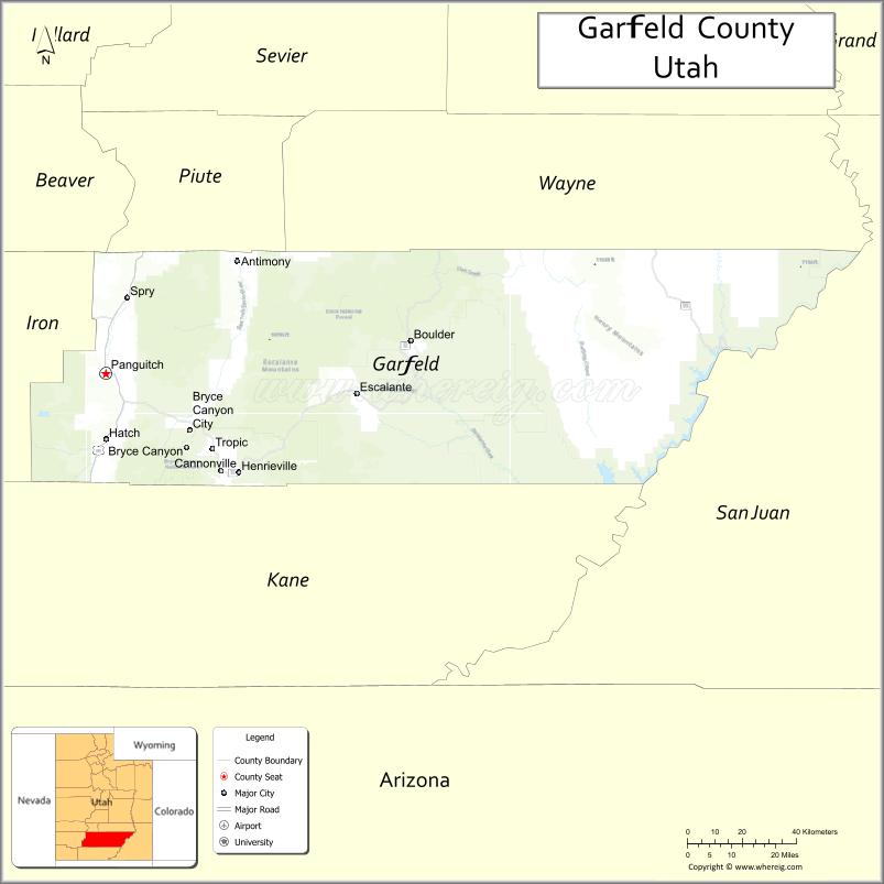
About Garfield County Map, Utah: The map showing the county boundary, county seat, major cities, and neighbouring counties.
Most Viewed Links
| Utah Map | Counties in Utah | Cities in Utah |
| Utah Zipcodes | Airports in Utah | US Zip code Map |
| Utah Area Codes | Utah River Map | - |
About Garfield County, Utah
Garfield County is a county located in the U.S. state of Utah. Its county seat is Panguitch. As per the 2020 census, the population of Garfield County is 5,129 people, and the population density is approximately 1.0 people per square mile. According to the United States Census Bureau, the county has a total area of 5,083 sq mi (13,165 km²). Garfield County was established on March 9, 1882.
Garfield County Facts
| Category | Details |
|---|---|
| County Name | Garfield County |
| State | Utah |
| Country | United States |
| Region | South-central Utah |
| County Seat | Panguitch |
| Established | 1882 |
| Total Area | 5,208 sq mi (13,492 sq km) |
| Land Area | 5,175 sq mi |
| Water Area | 33 sq mi |
| Population (2020) | 5,083 |
| Population Density | ~1 person per sq mi |
| Time Zone | Mountain Time Zone (MT) |
| Area Code | 435 |
| Nearest Airport | Bryce Canyon Airport |
| Famous For | Bryce Canyon National Park, Grand Staircase-Escalante, scenic landscapes |
| Tourist Places | Bryce Canyon National Park, Escalante Petrified Forest, Kodachrome Basin State Park |
| Nearby Cities | Kanab, UT; Escalante, UT; Panguitch, UT; Tropic, UT |
| FIPS Code | 49-017 |
| Official Website | garfield.utah.gov |
Cities and Towns in Garfield County, Utah
| City/Town | Population (2020) |
|---|---|
| Panguitch | 1,725 |
| Bryce Canyon City | 198 |
| Escalante | 797 |
| Boulder | 236 |
| Cannonville | 167 |
| Henrieville | 221 |
| Tropic | 530 |
Top Places to Visit in Garfield County, Utah
| Place | Description |
|---|---|
| Bryce Canyon National Park | Famous for its colorful hoodoos and easy viewpoints that make every visit memorable. |
| Grand Staircase-Escalante National Monument | A vast and wild area with canyons, cliffs, and hidden spots to explore. |
| Escalante Petrified Forest State Park | A quiet park with petrified wood, hiking trails, and a small lake. |
| Calf Creek Falls | A beautiful waterfall reached by a scenic hike through a desert canyon. |
| Boulder Mountain | A peaceful mountain area with forests, lakes, and cooler temperatures. |
| Anasazi State Park Museum | A small museum that shares the story of ancient Native American life in the area. |
| Hell’s Backbone Scenic Road | A narrow, adventurous drive with incredible views and a bit of thrill. |
| Capitol Reef National Park (part) | A section of this park reaches into the county with red rocks and scenic drives. |
| Devil’s Garden | A fun area with unique rock formations and easy spots to wander around. |
| Lower Calf Creek Falls | A popular hike leading to a stunning waterfall surrounded by red cliffs. |
- Beaver County Map
- Box Elder County Map
- Cache County Map
- Carbon County Map
- Daggett County Map
- Davis County Map
- Duchesne County Map
- Emery County Map
- Garfield County Map
- Grand County Map
- Iron County Map
- Juab County Map
- Kane County Map
- Millard County Map
- Morgan County Map
- Piute County Map
- Rich County Map
- Salt Lake County Map
- San Juan County Map
- Sanpete County Map
- Sevier County Map
- Summit County Map
- Tooele County Map
- Uintah County Map
- Utah County Map
- Wasatch County Map
- Washington County Map
- Wayne County Map
- Weber County Map
- Alabama Counties
- Alaska boroughs
- Arizona Counties
- Arkansas Counties
- California County Map
- Colorado Counties
- Connecticut Counties
- Delaware Counties
- Florida County Map
- Georgia County Map
- Hawaii Counties
- Idaho Counties
- Illinois Counties
- Indiana Counties
- Iowa Counties
- Kansas Counties
- Kentucky Counties
- Louisiana Counties
- Maine Counties
- Maryland Counties
- Massachusetts Counties
- Michigan County Map
- Minnesota Counties
- Mississippi Counties
- Missouri Counties
- Montana Counties
- Nebraska Counties
- Nevada Counties
- New York Counties
- New Hampshire Counties
- New Jersey Counties
- New Mexico Counties
- North Carolina Counties
- North Dakota Counties
- Ohio County Map
- Oklahoma Counties
- Oregon Counties
- Pennsylvania Counties
- Rhode Island Counties
- South Carolina Counties
- South Dakota Counties
- Map of Tennessee
- Texas County Map
- Utah Counties
- Vermont Counties
- Virginia Counties
- Washington Counties
- West Virginia Counties
- Wisconsin Counties
- Wyoming Counties