Map of Juab County - Juab County is a county located in the U.S. state of Utah. Juab County Map showing cities, highways, important places and water bodies. Get Where is Juab County located in the map, major cities in Juab county, population, areas, and places of interest.
Map of Juab County, Utah
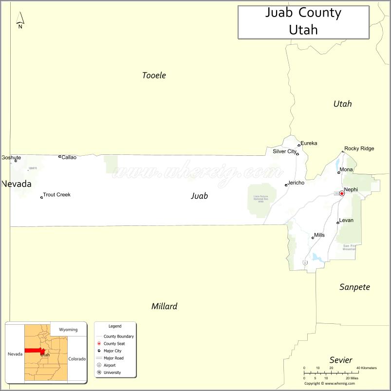
About Juab County Map, Utah: The map showing the county boundary, county seat, major cities, and neighbouring counties.
Most Viewed Links
| Utah Map | Counties in Utah | Cities in Utah |
| Utah Zipcodes | Airports in Utah | US Zip code Map |
| Utah Area Codes | Utah River Map | - |
About Juab County, Utah
Juab County is a county located in the U.S. state of Utah. Its county seat is Nephi. As per the 2020 census, the population of Juab County is 12,155 people, and the population density is approximately 3.6 people per square mile. According to the United States Census Bureau, the county has a total area of 3,392 sq mi (8,785 km²). Juab County was established on January 31, 1852.
Juab County Facts
| Category | Details |
|---|---|
| County Name | Juab County |
| State | Utah |
| Country | United States |
| Region | Central Utah |
| County Seat | Nephi |
| Established | 1852 |
| Total Area | 3,406 sq mi (8,821 sq km) |
| Land Area | 3,392 sq mi |
| Water Area | 14 sq mi |
| Population (2020) | 11,786 |
| Population Density | ~3 persons per sq mi |
| Time Zone | Mountain Time Zone (MT) |
| Area Code | 435 |
| Nearest Airport | Provo Municipal Airport |
| Famous For | Little Sahara Recreation Area, desert landscapes, mining |
| Tourist Places | Little Sahara Recreation Area, Yuba State Park, Tintic Mountains |
| Nearby Cities | Provo, UT; Nephi, UT; Delta, UT |
| FIPS Code | 49-023 |
| Official Website | juabcounty.gov |
Cities and Towns in Juab County, Utah
| City/Town | Population (2020) |
|---|---|
| Nephi | 6,195 |
| Mona | 2,126 |
| Levan | 862 |
| Eureka | 669 |
| Rocky Ridge | 833 |
Top Places to Visit in Juab County, Utah
| Place | Description |
|---|---|
| Little Sahara Recreation Area | A large area of sand dunes perfect for off-roading, camping, and having fun in the open desert. |
| Yuba State Park | A peaceful reservoir spot ideal for boating, fishing, and relaxing by the water. |
| Mount Nebo Scenic Byway | A beautiful mountain drive with sweeping views, especially nice during fall. |
| Fish Springs National Wildlife Refuge | A quiet and remote wetland area known for birdwatching and open landscapes. |
| Nephi City Park | A simple local park with green space, playgrounds, and a relaxed setting. |
| Uinta National Forest (part) | A section of forest land offering trails, fresh air, and peaceful nature spots. |
| Old West Millard County Line | A historic roadside area with a bit of local charm and open views. |
| Chicken Creek Reservoir | A quiet lake area perfect for fishing and enjoying a calm outdoor day. |
| Levan Ridge | A scenic spot with wide views and a peaceful, rural feel. |
| West Hills | A nearby hill area with simple trails and open space to explore. |
- Beaver County Map
- Box Elder County Map
- Cache County Map
- Carbon County Map
- Daggett County Map
- Davis County Map
- Duchesne County Map
- Emery County Map
- Garfield County Map
- Grand County Map
- Iron County Map
- Juab County Map
- Kane County Map
- Millard County Map
- Morgan County Map
- Piute County Map
- Rich County Map
- Salt Lake County Map
- San Juan County Map
- Sanpete County Map
- Sevier County Map
- Summit County Map
- Tooele County Map
- Uintah County Map
- Utah County Map
- Wasatch County Map
- Washington County Map
- Wayne County Map
- Weber County Map
- Alabama Counties
- Alaska boroughs
- Arizona Counties
- Arkansas Counties
- California County Map
- Colorado Counties
- Connecticut Counties
- Delaware Counties
- Florida County Map
- Georgia County Map
- Hawaii Counties
- Idaho Counties
- Illinois Counties
- Indiana Counties
- Iowa Counties
- Kansas Counties
- Kentucky Counties
- Louisiana Counties
- Maine Counties
- Maryland Counties
- Massachusetts Counties
- Michigan County Map
- Minnesota Counties
- Mississippi Counties
- Missouri Counties
- Montana Counties
- Nebraska Counties
- Nevada Counties
- New York Counties
- New Hampshire Counties
- New Jersey Counties
- New Mexico Counties
- North Carolina Counties
- North Dakota Counties
- Ohio County Map
- Oklahoma Counties
- Oregon Counties
- Pennsylvania Counties
- Rhode Island Counties
- South Carolina Counties
- South Dakota Counties
- Map of Tennessee
- Texas County Map
- Utah Counties
- Vermont Counties
- Virginia Counties
- Washington Counties
- West Virginia Counties
- Wisconsin Counties
- Wyoming Counties