Map of Kane County - Kane County is a county located in the U.S. state of Utah. Kane County Map showing cities, highways, important places and water bodies. Get Where is Kane County located in the map, major cities in Kane county, population, areas, and places of interest.
Map of Kane County, Utah
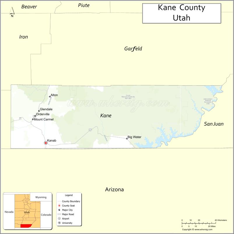
About Kane County Map, Utah: The map showing the county boundary, county seat, major cities, and neighbouring counties.
Most Viewed Links
| Utah Map | Counties in Utah | Cities in Utah |
| Utah Zipcodes | Airports in Utah | US Zip code Map |
| Utah Area Codes | Utah River Map | - |
About Kane County, Utah
Kane County is a county located in the U.S. state of Utah. Its county seat is Kanab. As per the 2020 census, the population of Kane County is 7,992 people, and the population density is approximately 2.0 people per square mile. According to the United States Census Bureau, the county has a total area of 3,990 sq mi (10,334 km²). Kane County was established on January 16, 1864.
<Kane County Facts
| Category | Details |
|---|---|
| County Name | Kane County |
| State | Utah |
| Country | United States |
| Region | Southern Utah |
| County Seat | Kanab |
| Established | 1864 |
| Total Area | 4,109 sq mi (10,637 sq km) |
| Land Area | 3,990 sq mi |
| Water Area | 119 sq mi |
| Population (2020) | 7,667 |
| Population Density | ~2 persons per sq mi |
| Time Zone | Mountain Time Zone (MT) |
| Area Code | 435 |
| Nearest Airport | Page Municipal Airport |
| Famous For | Grand Staircase-Escalante, The Wave, scenic desert landscapes |
| Tourist Places | Grand Staircase-Escalante National Monument, Coral Pink Sand Dunes, The Wave |
| Nearby Cities | Page, AZ; Kanab, UT; Orderville, UT |
| FIPS Code | 49-025 |
| Official Website | kanecountyutah.gov |
Cities and Towns in Kane County, Utah
| City/Town | Population (2020) |
|---|---|
| Kanab | 4,683 |
| Orderville | 577 |
| Glendale | 381 |
| Alton | 134 |
| Big Water | 456 |
Top Places to Visit in Kane County, Utah
| Place | Description |
|---|---|
| Zion National Park (part) | A stunning area with red cliffs, scenic hikes, and unforgettable canyon views. |
| Coral Pink Sand Dunes State Park | A unique spot with soft pink sand dunes, great for exploring and off-road fun. |
| Kanab | A small town known as “Little Hollywood,” with a charming feel and nearby adventures. |
| The Wave (Coyote Buttes) | A famous rock formation with smooth, colorful waves, accessed by permit only. |
| Grand Staircase-Escalante (part) | A vast desert area with canyons, cliffs, and hidden natural wonders. |
| Moqui Cave | A small roadside cave with interesting history and a quirky museum inside. |
| Best Friends Animal Sanctuary | A peaceful place dedicated to animal rescue, open for visits and tours. |
| Johnson Canyon | A quiet canyon known for its scenic beauty and occasional wildflower blooms. |
| Buckskin Gulch | One of the longest slot canyons, offering narrow passages and unique views. |
| Paria Canyon | A beautiful canyon with colorful rock walls, perfect for hiking and exploring. |
- Beaver County Map
- Box Elder County Map
- Cache County Map
- Carbon County Map
- Daggett County Map
- Davis County Map
- Duchesne County Map
- Emery County Map
- Garfield County Map
- Grand County Map
- Iron County Map
- Juab County Map
- Kane County Map
- Millard County Map
- Morgan County Map
- Piute County Map
- Rich County Map
- Salt Lake County Map
- San Juan County Map
- Sanpete County Map
- Sevier County Map
- Summit County Map
- Tooele County Map
- Uintah County Map
- Utah County Map
- Wasatch County Map
- Washington County Map
- Wayne County Map
- Weber County Map
- Alabama Counties
- Alaska boroughs
- Arizona Counties
- Arkansas Counties
- California County Map
- Colorado Counties
- Connecticut Counties
- Delaware Counties
- Florida County Map
- Georgia County Map
- Hawaii Counties
- Idaho Counties
- Illinois Counties
- Indiana Counties
- Iowa Counties
- Kansas Counties
- Kentucky Counties
- Louisiana Counties
- Maine Counties
- Maryland Counties
- Massachusetts Counties
- Michigan County Map
- Minnesota Counties
- Mississippi Counties
- Missouri Counties
- Montana Counties
- Nebraska Counties
- Nevada Counties
- New York Counties
- New Hampshire Counties
- New Jersey Counties
- New Mexico Counties
- North Carolina Counties
- North Dakota Counties
- Ohio County Map
- Oklahoma Counties
- Oregon Counties
- Pennsylvania Counties
- Rhode Island Counties
- South Carolina Counties
- South Dakota Counties
- Map of Tennessee
- Texas County Map
- Utah Counties
- Vermont Counties
- Virginia Counties
- Washington Counties
- West Virginia Counties
- Wisconsin Counties
- Wyoming Counties