Map of Summit County - Summit County is a county located in the U.S. state of Utah. Summit County Map showing cities, highways, important places and water bodies. Get Where is Summit County located in the map, major cities in Summit county, population, areas, and places of interest.
Map of Summit County, Utah
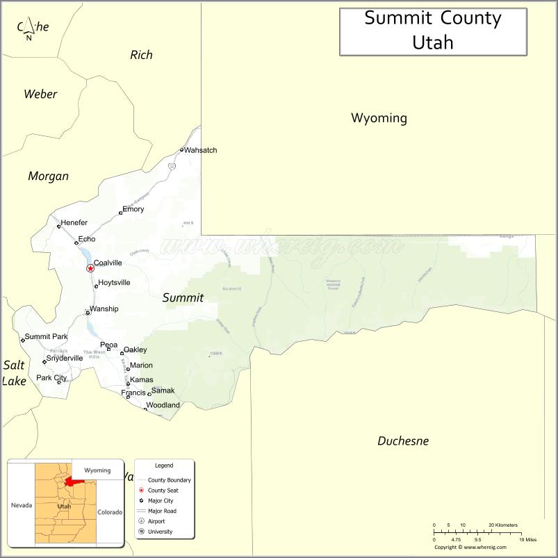
About Summit County Map, Utah: The map showing the county boundary, county seat, major cities, and neighbouring counties.
Most Viewed Links
| Utah Map | Counties in Utah | Cities in Utah |
| Utah Zipcodes | Airports in Utah | US Zip code Map |
| Utah Area Codes | Utah River Map | - |
About Summit County, Utah
Summit County is a county located in the U.S. state of Utah. Its county seat is Coalville. As per the 2020 census, the population of Summit County is 43,093 people, and the population density is approximately 23.0 people per square mile. According to the United States Census Bureau, the county has a total area of 1,872 sq mi (4,848 km²). Summit County was established on January 17, 1854.
Summit County Facts
| Category | Details |
|---|---|
| County Name | Summit County |
| State | Utah |
| Country | United States |
| Region | Northern Utah |
| County Seat | Coalville |
| Established | 1854 |
| Total Area | 1,882 sq mi (4,875 sq km) |
| Land Area | 1,871 sq mi |
| Water Area | 11 sq mi |
| Population (2020) | 42,357 |
| Population Density | ~23 persons per sq mi |
| Time Zone | Mountain Time Zone (MT) |
| Area Code | 435, 801 |
| Nearest Airport | Salt Lake City International Airport |
| Famous For | Park City, ski resorts, Sundance Film Festival |
| Tourist Places | Park City Mountain Resort, Deer Valley Resort, Utah Olympic Park |
| Nearby Cities | Park City, UT; Heber City, UT; Coalville, UT |
| FIPS Code | 49-043 |
| Official Website | summitcounty.org |
Cities and Towns in Summit County, Utah
| City/Town | Population (2020) |
|---|---|
| Park City | 8,396 |
| Kamas | 2,274 |
| Coalville | 1,382 |
| Francis | 1,583 |
| Henefer | 766 |
| Oakley | 1,470 |
Top Places to Visit in Summit County, Utah
| Place | Description |
|---|---|
| Park City Mountain Resort | A popular destination for skiing in winter and outdoor fun year-round. |
| Deer Valley Resort | A well-known ski resort offering great slopes and a more relaxed atmosphere. |
| Park City | A lively mountain town with shops, dining, and a charming historic feel. |
| Utah Olympic Park | A fun place to learn about the Olympics with activities and scenic views. |
| Swaner Preserve and EcoCenter | A peaceful nature area with trails and a chance to see local wildlife. |
| Jordanelle State Park | A scenic reservoir perfect for boating, fishing, and relaxing by the water. |
| Mirror Lake Scenic Byway | A beautiful mountain drive with lakes, forests, and stunning views. |
| Rockport State Park | A quiet lake area great for fishing, camping, and enjoying nature. |
| High Uintas Wilderness (part) | A remote wilderness with alpine lakes and great hiking opportunities. |
| Kimball Art Center | A local art space showcasing exhibits and creative work in a welcoming setting. |
- Beaver County Map
- Box Elder County Map
- Cache County Map
- Carbon County Map
- Daggett County Map
- Davis County Map
- Duchesne County Map
- Emery County Map
- Garfield County Map
- Grand County Map
- Iron County Map
- Juab County Map
- Kane County Map
- Millard County Map
- Morgan County Map
- Piute County Map
- Rich County Map
- Salt Lake County Map
- San Juan County Map
- Sanpete County Map
- Sevier County Map
- Summit County Map
- Tooele County Map
- Uintah County Map
- Utah County Map
- Wasatch County Map
- Washington County Map
- Wayne County Map
- Weber County Map
- Alabama Counties
- Alaska boroughs
- Arizona Counties
- Arkansas Counties
- California County Map
- Colorado Counties
- Connecticut Counties
- Delaware Counties
- Florida County Map
- Georgia County Map
- Hawaii Counties
- Idaho Counties
- Illinois Counties
- Indiana Counties
- Iowa Counties
- Kansas Counties
- Kentucky Counties
- Louisiana Counties
- Maine Counties
- Maryland Counties
- Massachusetts Counties
- Michigan County Map
- Minnesota Counties
- Mississippi Counties
- Missouri Counties
- Montana Counties
- Nebraska Counties
- Nevada Counties
- New York Counties
- New Hampshire Counties
- New Jersey Counties
- New Mexico Counties
- North Carolina Counties
- North Dakota Counties
- Ohio County Map
- Oklahoma Counties
- Oregon Counties
- Pennsylvania Counties
- Rhode Island Counties
- South Carolina Counties
- South Dakota Counties
- Map of Tennessee
- Texas County Map
- Utah Counties
- Vermont Counties
- Virginia Counties
- Washington Counties
- West Virginia Counties
- Wisconsin Counties
- Wyoming Counties