Map of Tooele County - Tooele County is a county located in the U.S. state of Utah. Tooele County Map showing cities, highways, important places and water bodies. Get Where is Tooele County located in the map, major cities in Tooele county, population, areas, and places of interest.
Map of Tooele County, Utah
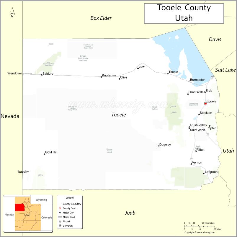
About Tooele County Map, Utah: The map showing the county boundary, county seat, major cities, and neighbouring counties.
Most Viewed Links
| Utah Map | Counties in Utah | Cities in Utah |
| Utah Zipcodes | Airports in Utah | US Zip code Map |
| Utah Area Codes | Utah River Map | - |
About Tooele County, Utah
Tooele County is a county located in the U.S. state of Utah. Its county seat is Tooele. As per the 2020 census, the population of Tooele County is 76,640 people, and the population density is approximately 11.0 people per square mile. According to the United States Census Bureau, the county has a total area of 6,941 sq mi (17,977 km²). Tooele County was established on January 31, 1850.
Tooele County Facts
| Category | Details |
|---|---|
| County Name | Tooele County |
| State | Utah |
| Country | United States |
| Region | Northwestern Utah |
| County Seat | Tooele |
| Established | 1852 |
| Total Area | 7,287 sq mi (18,873 sq km) |
| Land Area | 6,941 sq mi |
| Water Area | 346 sq mi |
| Population (2020) | 72,698 |
| Population Density | ~10 persons per sq mi |
| Time Zone | Mountain Time Zone (MT) |
| Area Code | 435, 801 |
| Nearest Airport | Salt Lake City International Airport |
| Famous For | Bonneville Salt Flats, Great Salt Lake Desert, military testing sites |
| Tourist Places | Bonneville Salt Flats, Great Salt Lake Desert, Dugway Geode Beds |
| Nearby Cities | Salt Lake City, UT; Tooele, UT; Grantsville, UT |
| FIPS Code | 49-045 |
| Official Website | tooeleco.gov |
Cities and Towns in Tooele County, Utah
| City/Town | Population (2020) |
|---|---|
| Tooele | 36,605 |
| Grantsville | 11,747 |
| Stansbury Park | 10,653 |
| Erda | 6,087 |
| Stockton | 724 |
| Rush Valley | 447 |
| Vernon | 236 |
| Wendover | 1,386 |
Top Places to Visit in Tooele County, Utah
| Place | Description |
|---|---|
| Bonneville Salt Flats | A wide, bright white landscape known for its unique look and land speed events. |
| Great Salt Lake (west side) | A quiet side of the lake with open views and peaceful surroundings. |
| Deseret Peak Wilderness | A scenic mountain area with hiking trails and beautiful alpine views. |
| Stansbury Island | A remote spot with rugged terrain and wide-open desert scenery. |
| Grantsville Reservoir | A calm local spot for fishing and enjoying a relaxing day outdoors. |
| Tooele Valley Railroad Museum | A small museum highlighting the area’s railroad history. |
| Settlement Canyon | A quiet canyon with trails, picnic spots, and a peaceful setting. |
| Oquirrh Mountains | A nearby mountain range offering scenic views and outdoor exploration. |
| Deseret Peak Complex | A local recreation area with events, rodeos, and open space. |
| Erda Park | A simple community park with green space and a relaxed atmosphere. |
- Beaver County Map
- Box Elder County Map
- Cache County Map
- Carbon County Map
- Daggett County Map
- Davis County Map
- Duchesne County Map
- Emery County Map
- Garfield County Map
- Grand County Map
- Iron County Map
- Juab County Map
- Kane County Map
- Millard County Map
- Morgan County Map
- Piute County Map
- Rich County Map
- Salt Lake County Map
- San Juan County Map
- Sanpete County Map
- Sevier County Map
- Summit County Map
- Tooele County Map
- Uintah County Map
- Utah County Map
- Wasatch County Map
- Washington County Map
- Wayne County Map
- Weber County Map
- Alabama Counties
- Alaska boroughs
- Arizona Counties
- Arkansas Counties
- California County Map
- Colorado Counties
- Connecticut Counties
- Delaware Counties
- Florida County Map
- Georgia County Map
- Hawaii Counties
- Idaho Counties
- Illinois Counties
- Indiana Counties
- Iowa Counties
- Kansas Counties
- Kentucky Counties
- Louisiana Counties
- Maine Counties
- Maryland Counties
- Massachusetts Counties
- Michigan County Map
- Minnesota Counties
- Mississippi Counties
- Missouri Counties
- Montana Counties
- Nebraska Counties
- Nevada Counties
- New York Counties
- New Hampshire Counties
- New Jersey Counties
- New Mexico Counties
- North Carolina Counties
- North Dakota Counties
- Ohio County Map
- Oklahoma Counties
- Oregon Counties
- Pennsylvania Counties
- Rhode Island Counties
- South Carolina Counties
- South Dakota Counties
- Map of Tennessee
- Texas County Map
- Utah Counties
- Vermont Counties
- Virginia Counties
- Washington Counties
- West Virginia Counties
- Wisconsin Counties
- Wyoming Counties