Map of Daggett County - Daggett County is a county located in the U.S. state of Utah. Daggett County Map showing cities, highways, important places and water bodies. Get Where is Daggett County located in the map, major cities in Daggett county, population, areas, and places of interest.
Map of Daggett County, Utah
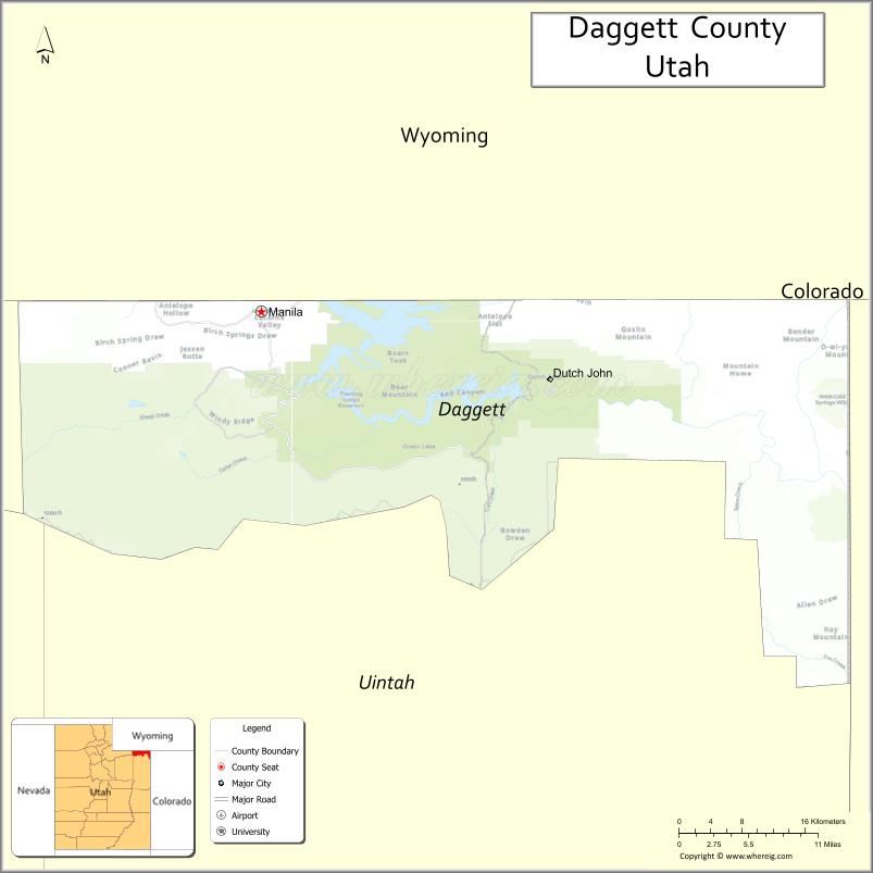
About Daggett County Map, Utah: The map showing the county boundary, county seat, major cities, and neighbouring counties.
Most Viewed Links
| Utah Map | Counties in Utah | Cities in Utah |
| Utah Zipcodes | Airports in Utah | US Zip code Map |
| Utah Area Codes | Utah River Map | - |
About Daggett County, Utah
Daggett County is a county located in the U.S. state of Utah. Its county seat is Manila. As per the 2020 census, the population of Daggett County is 976 people, and the population density is approximately 1.4 people per square mile. According to the United States Census Bureau, the county has a total area of 697 sq mi (1,805 km²). Daggett County was established on January 17, 1918.
<Daggett County, Utah Facts
| Category | Details |
|---|---|
| County Name | Daggett County |
| State | Utah |
| Country | United States |
| Region | Northeastern Utah |
| County Seat | Manila |
| Established | 1918 |
| Total Area | 721 sq mi (1,867 sq km) |
| Land Area | 697 sq mi |
| Water Area | 24 sq mi |
| Population (2020) | 935 |
| Population Density | ~1 person per sq mi |
| Time Zone | Mountain Time Zone (MT) |
| Area Code | 435 |
| Nearest Airport | Vernal Regional Airport |
| Famous For | Flaming Gorge Reservoir, outdoor recreation, scenic landscapes |
| Tourist Places | Flaming Gorge National Recreation Area, Red Canyon, Sheep Creek Geological Loop |
| Nearby Cities | Vernal, UT; Manila, UT; Dutch John, UT |
| FIPS Code | 49-009 |
| Official Website | daggettcounty.org |
Cities and Towns in Daggett County, Utah
| City/Town | Population (2020) |
|---|---|
| Manila | 308 |
Top Places to Visit in Daggett County, Utah
| Place | Description |
|---|---|
| Flaming Gorge Reservoir | A stunning lake with clear blue water, perfect for boating, fishing, and relaxing by the shore. |
| Flaming Gorge Dam | An impressive dam with great views and a chance to learn about how the area is managed. |
| Red Canyon Overlook | A scenic viewpoint with wide views of red cliffs and the lake below. |
| Green River | A calm river flowing through the area, popular for fishing and peaceful floats. |
| Sheep Creek Geological Loop | A unique drive with striking rock formations and interesting geology along the way. |
| Browns Park | A quiet valley known for its history, wildlife, and open landscapes. |
| Lucerne Valley Marina | A convenient spot for launching boats, fishing, and enjoying time on the water. |
| Mustang Ridge | A remote area with open views where wild horses are sometimes seen. |
| Cart Creek Bridge | A simple but scenic spot with river views and a bit of local charm. |
| Daggett County Courthouse | A small historic building that reflects the county’s quiet and rural character. |
- Beaver County Map
- Box Elder County Map
- Cache County Map
- Carbon County Map
- Daggett County Map
- Davis County Map
- Duchesne County Map
- Emery County Map
- Garfield County Map
- Grand County Map
- Iron County Map
- Juab County Map
- Kane County Map
- Millard County Map
- Morgan County Map
- Piute County Map
- Rich County Map
- Salt Lake County Map
- San Juan County Map
- Sanpete County Map
- Sevier County Map
- Summit County Map
- Tooele County Map
- Uintah County Map
- Utah County Map
- Wasatch County Map
- Washington County Map
- Wayne County Map
- Weber County Map
- Alabama Counties
- Alaska boroughs
- Arizona Counties
- Arkansas Counties
- California County Map
- Colorado Counties
- Connecticut Counties
- Delaware Counties
- Florida County Map
- Georgia County Map
- Hawaii Counties
- Idaho Counties
- Illinois Counties
- Indiana Counties
- Iowa Counties
- Kansas Counties
- Kentucky Counties
- Louisiana Counties
- Maine Counties
- Maryland Counties
- Massachusetts Counties
- Michigan County Map
- Minnesota Counties
- Mississippi Counties
- Missouri Counties
- Montana Counties
- Nebraska Counties
- Nevada Counties
- New York Counties
- New Hampshire Counties
- New Jersey Counties
- New Mexico Counties
- North Carolina Counties
- North Dakota Counties
- Ohio County Map
- Oklahoma Counties
- Oregon Counties
- Pennsylvania Counties
- Rhode Island Counties
- South Carolina Counties
- South Dakota Counties
- Map of Tennessee
- Texas County Map
- Utah Counties
- Vermont Counties
- Virginia Counties
- Washington Counties
- West Virginia Counties
- Wisconsin Counties
- Wyoming Counties