Map of Morgan County - Morgan County is a county located in the U.S. state of Utah. Morgan County Map showing cities, highways, important places and water bodies. Get Where is Morgan County located in the map, major cities in Morgan county, population, areas, and places of interest.
Map of Morgan County, Utah
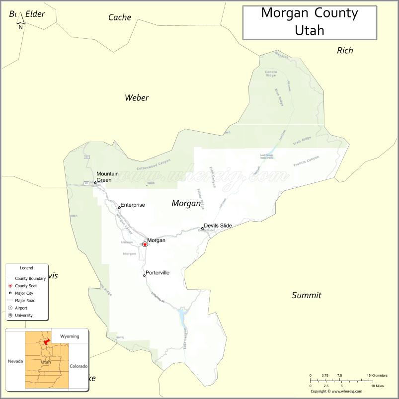
About Morgan County Map, Utah: The map showing the county boundary, county seat, major cities, and neighbouring counties.
Most Viewed Links
| Utah Map | Counties in Utah | Cities in Utah |
| Utah Zipcodes | Airports in Utah | US Zip code Map |
| Utah Area Codes | Utah River Map | - |
About Morgan County, Utah
Morgan County is a county located in the U.S. state of Utah. Its county seat is Morgan. As per the 2020 census, the population of Morgan County is 12,657 people, and the population density is approximately 20.8 people per square mile. According to the United States Census Bureau, the county has a total area of 609 sq mi (1,577 km²). Morgan County was established on February 17, 1862.
Morgan County Facts
| Category | Details |
|---|---|
| County Name | Morgan County |
| State | Utah |
| Country | United States |
| Region | Northern Utah |
| County Seat | Morgan |
| Established | 1862 |
| Total Area | 611 sq mi (1,582 sq km) |
| Land Area | 609 sq mi |
| Water Area | 2 sq mi |
| Population (2020) | 12,295 |
| Population Density | ~20 persons per sq mi |
| Time Zone | Mountain Time Zone (MT) |
| Area Code | 385, 801 |
| Nearest Airport | Ogden-Hinckley Airport |
| Famous For | Mountain valleys, scenic drives, outdoor recreation |
| Tourist Places | East Canyon State Park, Devil's Slide, Weber Canyon |
| Nearby Cities | Ogden, UT; Layton, UT; Morgan, UT |
| FIPS Code | 49-029 |
| Official Website | morgan-county.net |
Cities and Towns in Morgan County, Utah
| City/Town | Population (2020) |
|---|---|
| Morgan | 4,071 |
| Mountain Green | 3,329 |
| Enterprise | 162 |
| Peterson | 1,329 |
Top Places to Visit in Morgan County, Utah
| Place | Description |
|---|---|
| East Canyon State Park | A calm reservoir spot perfect for boating, fishing, and a relaxing day outdoors. |
| East Canyon Reservoir | A scenic lake with open views, great for water activities and picnics. |
| Devil’s Slide | A unique rock formation that stands out along the hillside and makes for a quick stop. |
| Morgan Valley | A peaceful valley with wide open views and a quiet, rural feel. |
| Weber River | A gentle river ideal for fishing, tubing, or simply enjoying the scenery. |
| Round Valley | A quiet area with open land, perfect for relaxing drives and nature views. |
| Lost Creek Reservoir | A smaller, peaceful lake that’s great for fishing and escaping the crowds. |
| Wasatch Mountains (part) | A scenic mountain area offering trails, views, and fresh air. |
| Mountain Green | A small community surrounded by nature, known for its quiet charm. |
| Morgan City Park | A simple local park with green space, playgrounds, and a relaxed setting. |
- Beaver County Map
- Box Elder County Map
- Cache County Map
- Carbon County Map
- Daggett County Map
- Davis County Map
- Duchesne County Map
- Emery County Map
- Garfield County Map
- Grand County Map
- Iron County Map
- Juab County Map
- Kane County Map
- Millard County Map
- Morgan County Map
- Piute County Map
- Rich County Map
- Salt Lake County Map
- San Juan County Map
- Sanpete County Map
- Sevier County Map
- Summit County Map
- Tooele County Map
- Uintah County Map
- Utah County Map
- Wasatch County Map
- Washington County Map
- Wayne County Map
- Weber County Map
- Alabama Counties
- Alaska boroughs
- Arizona Counties
- Arkansas Counties
- California County Map
- Colorado Counties
- Connecticut Counties
- Delaware Counties
- Florida County Map
- Georgia County Map
- Hawaii Counties
- Idaho Counties
- Illinois Counties
- Indiana Counties
- Iowa Counties
- Kansas Counties
- Kentucky Counties
- Louisiana Counties
- Maine Counties
- Maryland Counties
- Massachusetts Counties
- Michigan County Map
- Minnesota Counties
- Mississippi Counties
- Missouri Counties
- Montana Counties
- Nebraska Counties
- Nevada Counties
- New York Counties
- New Hampshire Counties
- New Jersey Counties
- New Mexico Counties
- North Carolina Counties
- North Dakota Counties
- Ohio County Map
- Oklahoma Counties
- Oregon Counties
- Pennsylvania Counties
- Rhode Island Counties
- South Carolina Counties
- South Dakota Counties
- Map of Tennessee
- Texas County Map
- Utah Counties
- Vermont Counties
- Virginia Counties
- Washington Counties
- West Virginia Counties
- Wisconsin Counties
- Wyoming Counties