Map of Uintah County - Uintah County is a county located in the U.S. state of Utah. Uintah County Map showing cities, highways, important places and water bodies. Get Where is Uintah County located in the map, major cities in Uintah county, population, areas, and places of interest.
Map of Uintah County, Utah
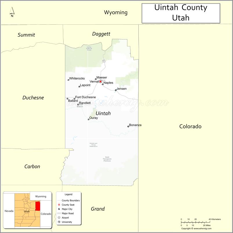
About Uintah County Map, Utah: The map showing the county boundary, county seat, major cities, and neighbouring counties.
Most Viewed Links
| Utah Map | Counties in Utah | Cities in Utah |
| Utah Zipcodes | Airports in Utah | US Zip code Map |
| Utah Area Codes | Utah River Map | - |
About Uintah County, Utah
Uintah County is a county located in the U.S. state of Utah. Its county seat is Vernal. As per the 2020 census, the population of Uintah County is 36,204 people, and the population density is approximately 8.1 people per square mile. According to the United States Census Bureau, the county has a total area of 4,480 sq mi (11,603 km²). Uintah County was established on February 18, 1880.
Uintah County Facts
| Category | Details |
|---|---|
| County Name | Uintah County |
| State | Utah |
| Country | United States |
| Region | Northeastern Utah |
| County Seat | Vernal |
| Established | 1880 |
| Total Area | 4,501 sq mi (11,657 sq km) |
| Land Area | 4,480 sq mi |
| Water Area | 21 sq mi |
| Population (2020) | 35,620 |
| Population Density | ~8 persons per sq mi |
| Time Zone | Mountain Time Zone (MT) |
| Area Code | 435 |
| Nearest Airport | Vernal Regional Airport |
| Famous For | Dinosaur fossils, Uinta Basin, oil and gas production |
| Tourist Places | Dinosaur National Monument, Utah Field House of Natural History, Red Fleet State Park |
| Nearby Cities | Roosevelt, UT; Duchesne, UT; Vernal, UT |
| FIPS Code | 49-047 |
| Official Website | uintah.utah.gov |
Cities and Towns in Uintah County, Utah
| City/Town | Population (2020) |
|---|---|
| Vernal | 10,370 |
| Naples | 2,357 |
| Ballard | 1,312 |
Top Places to Visit in Uintah County, Utah
| Place | Description |
|---|---|
| Dinosaur National Monument | A fascinating site with real dinosaur fossils and scenic canyon views. |
| Red Fleet State Park | A scenic reservoir surrounded by red rocks, known for boating and nearby dinosaur tracks. |
| Steinaker State Park | A calm lake area great for fishing, boating, and easy outdoor days. |
| McConkie Ranch Petroglyphs | An interesting spot featuring ancient rock carvings and a quiet setting. |
| Uinta Mountains | A rugged mountain range with cool air, lakes, and great hiking trails. |
| Vernal | A small town known as the gateway to dinosaur country with local shops and museums. |
| Green River | A scenic river perfect for rafting, fishing, or simply enjoying the views. |
| Split Mountain | A striking rock formation where the river cuts through, offering great views. |
| Fantasy Canyon | A unique area filled with unusual rock shapes that feel almost otherworldly. |
| Dry Fork Canyon | A peaceful canyon known for its rock art and scenic surroundings. |
- Beaver County Map
- Box Elder County Map
- Cache County Map
- Carbon County Map
- Daggett County Map
- Davis County Map
- Duchesne County Map
- Emery County Map
- Garfield County Map
- Grand County Map
- Iron County Map
- Juab County Map
- Kane County Map
- Millard County Map
- Morgan County Map
- Piute County Map
- Rich County Map
- Salt Lake County Map
- San Juan County Map
- Sanpete County Map
- Sevier County Map
- Summit County Map
- Tooele County Map
- Uintah County Map
- Utah County Map
- Wasatch County Map
- Washington County Map
- Wayne County Map
- Weber County Map
- Alabama Counties
- Alaska boroughs
- Arizona Counties
- Arkansas Counties
- California County Map
- Colorado Counties
- Connecticut Counties
- Delaware Counties
- Florida County Map
- Georgia County Map
- Hawaii Counties
- Idaho Counties
- Illinois Counties
- Indiana Counties
- Iowa Counties
- Kansas Counties
- Kentucky Counties
- Louisiana Counties
- Maine Counties
- Maryland Counties
- Massachusetts Counties
- Michigan County Map
- Minnesota Counties
- Mississippi Counties
- Missouri Counties
- Montana Counties
- Nebraska Counties
- Nevada Counties
- New York Counties
- New Hampshire Counties
- New Jersey Counties
- New Mexico Counties
- North Carolina Counties
- North Dakota Counties
- Ohio County Map
- Oklahoma Counties
- Oregon Counties
- Pennsylvania Counties
- Rhode Island Counties
- South Carolina Counties
- South Dakota Counties
- Map of Tennessee
- Texas County Map
- Utah Counties
- Vermont Counties
- Virginia Counties
- Washington Counties
- West Virginia Counties
- Wisconsin Counties
- Wyoming Counties