Map of Beaver County - Beaver County is a county located in the U.S. state of Utah. Beaver County Map showing cities, highways, important places and water bodies. Get Where is Beaver County located in the map, major cities in Beaver county, population, areas, and places of interest.
Map of Beaver County, Utah
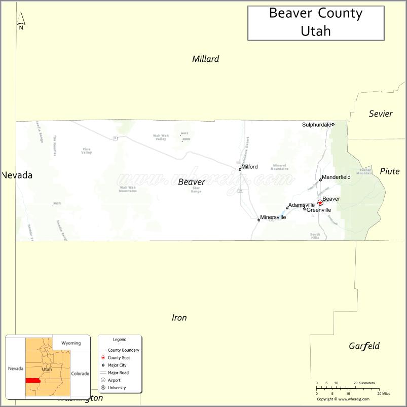
About Beaver County Map, Utah: The map showing the county boundary, county seat, major cities, and neighbouring counties.
Most Viewed Links
| Utah Map | Counties in Utah | Cities in Utah |
| Utah Zipcodes | Airports in Utah | US Zip code Map |
| Utah Area Codes | Utah River Map | - |
About Beaver County, Utah
Beaver County is a county located in the U.S. state of Utah. Its county seat is Beaver. As per the 2020 census, the population of Beaver County is 7,249 people, and the population density is approximately 2.8 people per square mile. According to the United States Census Bureau, the county has a total area of 2,590 sq mi (6,708 km²). Beaver County was established on January 5, 1856.
Beaver County Facts
| Category | Details |
|---|---|
| County Name | Beaver County |
| State | Utah |
| Country | United States |
| Region | Southwestern Utah |
| County Seat | Beaver |
| Established | 1856 |
| Total Area | 2,592 sq mi (6,714 sq km) |
| Land Area | 2,590 sq mi |
| Water Area | 2 sq mi |
| Population (2020) | 7,072 |
| Population Density | ~3 persons per sq mi |
| Time Zone | Mountain Time Zone (MT) |
| Area Code | 435 |
| Nearest Airport | Cedar City Regional Airport |
| Famous For | Historic sites, mining history, scenic mountains |
| Tourist Places | Tushar Mountains, Beaver Canyon, Minersville Reservoir |
| Nearby Cities | Cedar City, UT; Milford, UT; Beaver, UT |
| FIPS Code | 49-001 |
| Official Website | beaver.utah.gov |
Cities and Towns in Beaver County, Utah
| City/Town | Population (2020) |
|---|---|
| Beaver | 3,592 |
| Milford | 1,431 |
| Minersville | 907 |
Top Places to Visit in Beaver County, Utah
| Place | Description |
|---|---|
| Eagle Point Ski Resort | A quiet ski spot with great snow and fewer crowds, perfect for a relaxed winter trip. |
| Tushar Mountains | A cool mountain area with scenic views and peaceful trails for hiking. |
| Fishlake National Forest | A calm forest setting with camping spots, fishing areas, and plenty of space to unwind. |
| Beaver Canyon Scenic Byway | A scenic drive through a canyon with beautiful views, especially in fall. |
| Mineral Mountains | A rugged and quiet area with open landscapes, great for exploring. |
| Three Peaks Recreation Area | A fun outdoor spot for hiking, biking, and off-road adventures. |
| Beaver River | A small, peaceful river with nice spots to relax or fish. |
| Cove Fort | A historic fort that gives a glimpse into early pioneer life. |
| Frisco Ghost Town | An old mining town with a quiet, abandoned feel and interesting history. |
| Puffer Lake | A peaceful mountain lake, perfect for fishing or just enjoying the view. |
- Beaver County Map
- Box Elder County Map
- Cache County Map
- Carbon County Map
- Daggett County Map
- Davis County Map
- Duchesne County Map
- Emery County Map
- Garfield County Map
- Grand County Map
- Iron County Map
- Juab County Map
- Kane County Map
- Millard County Map
- Morgan County Map
- Piute County Map
- Rich County Map
- Salt Lake County Map
- San Juan County Map
- Sanpete County Map
- Sevier County Map
- Summit County Map
- Tooele County Map
- Uintah County Map
- Utah County Map
- Wasatch County Map
- Washington County Map
- Wayne County Map
- Weber County Map
- Alabama Counties
- Alaska boroughs
- Arizona Counties
- Arkansas Counties
- California County Map
- Colorado Counties
- Connecticut Counties
- Delaware Counties
- Florida County Map
- Georgia County Map
- Hawaii Counties
- Idaho Counties
- Illinois Counties
- Indiana Counties
- Iowa Counties
- Kansas Counties
- Kentucky Counties
- Louisiana Counties
- Maine Counties
- Maryland Counties
- Massachusetts Counties
- Michigan County Map
- Minnesota Counties
- Mississippi Counties
- Missouri Counties
- Montana Counties
- Nebraska Counties
- Nevada Counties
- New York Counties
- New Hampshire Counties
- New Jersey Counties
- New Mexico Counties
- North Carolina Counties
- North Dakota Counties
- Ohio County Map
- Oklahoma Counties
- Oregon Counties
- Pennsylvania Counties
- Rhode Island Counties
- South Carolina Counties
- South Dakota Counties
- Map of Tennessee
- Texas County Map
- Utah Counties
- Vermont Counties
- Virginia Counties
- Washington Counties
- West Virginia Counties
- Wisconsin Counties
- Wyoming Counties