Map of Salt Lake County - Salt Lake County is a county located in the U.S. state of Utah. Salt Lake County Map showing cities, highways, important places and water bodies. Get Where is Salt Lake County located in the map, major cities in Salt Lake county, population, areas, and places of interest.
Map of Salt Lake County, Utah
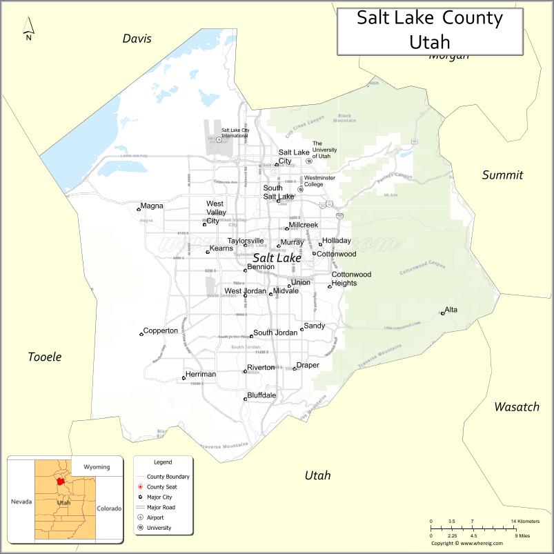
About Salt Lake County Map, Utah: The map showing the county boundary, county seat, major cities, and neighbouring counties.
Most Viewed Links
| Utah Map | Counties in Utah | Cities in Utah |
| Utah Zipcodes | Airports in Utah | US Zip code Map |
| Utah Area Codes | Utah River Map | - |
About Salt Lake County, Utah
Salt Lake County is a county located in the U.S. state of Utah. Its county seat is Salt Lake City. As per the 2020 census, the population of Salt Lake County is 1,186,421 people, and the population density is approximately 1,599 people per square mile. According to the United States Census Bureau, the county has a total area of 742 sq mi (1,922 km²). Salt Lake County was established on January 31, 1850.
Salt Lake County Facts
| Category | Details |
|---|---|
| County Name | Salt Lake County |
| State | Utah |
| Country | United States |
| Region | Northern Utah |
| County Seat | Salt Lake City |
| Established | 1850 |
| Total Area | 807 sq mi (2,090 sq km) |
| Land Area | 742 sq mi |
| Water Area | 65 sq mi |
| Population (2020) | 1,185,238 |
| Population Density | ~1,597 persons per sq mi |
| Time Zone | Mountain Time Zone (MT) |
| Area Code | 385, 801 |
| Nearest Airport | Salt Lake City International Airport |
| Famous For | Salt Lake City, Great Salt Lake, Wasatch Mountains |
| Tourist Places | Temple Square, Great Salt Lake, Big Cottonwood Canyon, Snowbird Ski Resort |
| Nearby Cities | West Valley City, UT; Sandy, UT; South Jordan, UT; Draper, UT |
| FIPS Code | 49-035 |
| Official Website | slco.org |
Cities and Towns in Salt Lake County, Utah
| City/Town | Population (2020) |
|---|---|
| Salt Lake City | 199,723 |
| West Valley City | 140,230 |
| West Jordan | 116,961 |
| Sandy | 96,904 |
| South Jordan | 77,487 |
| Murray | 50,637 |
| Taylorsville | 60,448 |
| Midvale | 35,235 |
| Herriman | 55,144 |
| Riverton | 44,419 |
| Draper | 51,017 |
| Millcreek | 63,380 |
| Cottonwood Heights | 34,449 |
| Holladay | 31,965 |
| South Salt Lake | 26,777 |
| Bluffdale | 17,014 |
| Magna | 28,333 |
Top Places to Visit in Salt Lake County, Utah
| Place | Description |
|---|---|
| Temple Square | A well-known downtown spot with historic buildings and a peaceful atmosphere. |
| Great Salt Lake | A unique lake famous for its salty water and wide, open views. |
| Utah State Capitol | A beautiful building set on a hill with great views over the city. |
| Hogle Zoo | A popular family-friendly place with animals from around the world. |
| Big Cottonwood Canyon | A scenic canyon with hiking trails, waterfalls, and mountain views. |
| Little Cottonwood Canyon | A beautiful canyon known for skiing, hiking, and dramatic scenery. |
| Snowbird Resort | A well-known resort offering skiing in winter and scenic rides in summer. |
| Alta Ski Area | A favorite spot for skiing with great snow and a classic mountain feel. |
| Liberty Park | A large city park with open space, a lake, and relaxing walking paths. |
| Red Butte Garden | A peaceful botanical garden with walking paths and seasonal flowers. |
- Beaver County Map
- Box Elder County Map
- Cache County Map
- Carbon County Map
- Daggett County Map
- Davis County Map
- Duchesne County Map
- Emery County Map
- Garfield County Map
- Grand County Map
- Iron County Map
- Juab County Map
- Kane County Map
- Millard County Map
- Morgan County Map
- Piute County Map
- Rich County Map
- Salt Lake County Map
- San Juan County Map
- Sanpete County Map
- Sevier County Map
- Summit County Map
- Tooele County Map
- Uintah County Map
- Utah County Map
- Wasatch County Map
- Washington County Map
- Wayne County Map
- Weber County Map
- Alabama Counties
- Alaska boroughs
- Arizona Counties
- Arkansas Counties
- California County Map
- Colorado Counties
- Connecticut Counties
- Delaware Counties
- Florida County Map
- Georgia County Map
- Hawaii Counties
- Idaho Counties
- Illinois Counties
- Indiana Counties
- Iowa Counties
- Kansas Counties
- Kentucky Counties
- Louisiana Counties
- Maine Counties
- Maryland Counties
- Massachusetts Counties
- Michigan County Map
- Minnesota Counties
- Mississippi Counties
- Missouri Counties
- Montana Counties
- Nebraska Counties
- Nevada Counties
- New York Counties
- New Hampshire Counties
- New Jersey Counties
- New Mexico Counties
- North Carolina Counties
- North Dakota Counties
- Ohio County Map
- Oklahoma Counties
- Oregon Counties
- Pennsylvania Counties
- Rhode Island Counties
- South Carolina Counties
- South Dakota Counties
- Map of Tennessee
- Texas County Map
- Utah Counties
- Vermont Counties
- Virginia Counties
- Washington Counties
- West Virginia Counties
- Wisconsin Counties
- Wyoming Counties