Map of Grand County - Grand County is a county located in the U.S. state of Utah. Grand County Map showing cities, highways, important places and water bodies. Get Where is Grand County located in the map, major cities in Grand county, population, areas, and places of interest.
Map of Grand County, Utah
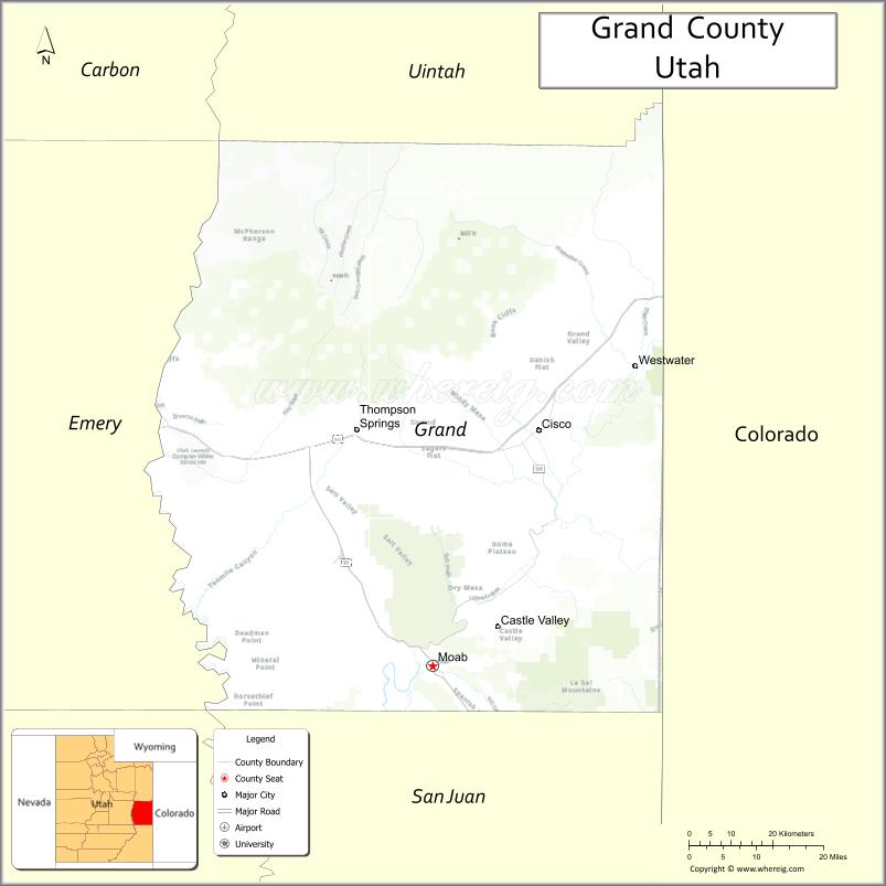
About Grand County Map, Utah: The map showing the county boundary, county seat, major cities, and neighbouring counties.
Most Viewed Links
| Utah Map | Counties in Utah | Cities in Utah |
| Utah Zipcodes | Airports in Utah | US Zip code Map |
| Utah Area Codes | Utah River Map | - |
About Grand County, Utah
Grand County is a county located in the U.S. state of Utah. Its county seat is Moab. As per the 2020 census, the population of Grand County is 9,663 people, and the population density is approximately 2.6 people per square mile. According to the United States Census Bureau, the county has a total area of 3,672 sq mi (9,510 km²). Grand County was established on March 13, 1890.
Grand County Facts
| Category | Details |
|---|---|
| County Name | Grand County |
| State | Utah |
| Country | United States |
| Region | Eastern Utah |
| County Seat | Moab |
| Established | 1890 |
| Total Area | 3,684 sq mi (9,544 sq km) |
| Land Area | 3,672 sq mi |
| Water Area | 12 sq mi |
| Population (2020) | 9,669 |
| Population Density | ~3 persons per sq mi |
| Time Zone | Mountain Time Zone (MT) |
| Area Code | 435 |
| Nearest Airport | Canyonlands Field Airport |
| Famous For | Arches National Park, Moab tourism, red rock landscapes |
| Tourist Places | Arches National Park, Canyonlands National Park, Dead Horse Point State Park |
| Nearby Cities | Green River, UT; Monticello, UT; Moab, UT |
| FIPS Code | 49-019 |
| Official Website | grandcountyutah.net |
Cities and Towns in Grand County, Utah
| City/Town | Population (2020) |
|---|---|
| Moab | 5,366 |
| Castle Valley | 351 |
| Thompson Springs | 39 |
Top Places to Visit in Grand County, Utah
| Place | Description |
|---|---|
| Arches National Park | Famous for its natural stone arches and easy viewpoints with stunning desert scenery. |
| Canyonlands National Park | A vast park with deep canyons and dramatic overlooks that feel wild and untouched. |
| Dead Horse Point State Park | A breathtaking viewpoint with sweeping views of the Colorado River far below. |
| Moab | A lively town known for outdoor adventures, local shops, and a welcoming vibe. |
| Colorado River | A scenic river perfect for rafting, kayaking, or just enjoying the views. |
| Corona Arch | A large and impressive arch reached by a short and rewarding hike. |
| Island in the Sky District | A popular area of Canyonlands with easy overlooks and wide canyon views. |
| Delicate Arch | The most iconic arch in Utah, known for its unique shape and sunset views. |
| La Sal Mountains | A cool mountain escape offering forest trails and a break from the desert heat. |
| Sand Flats Recreation Area | A fun area for off-roading, biking, and enjoying open desert landscapes. |
- Beaver County Map
- Box Elder County Map
- Cache County Map
- Carbon County Map
- Daggett County Map
- Davis County Map
- Duchesne County Map
- Emery County Map
- Garfield County Map
- Grand County Map
- Iron County Map
- Juab County Map
- Kane County Map
- Millard County Map
- Morgan County Map
- Piute County Map
- Rich County Map
- Salt Lake County Map
- San Juan County Map
- Sanpete County Map
- Sevier County Map
- Summit County Map
- Tooele County Map
- Uintah County Map
- Utah County Map
- Wasatch County Map
- Washington County Map
- Wayne County Map
- Weber County Map
- Alabama Counties
- Alaska boroughs
- Arizona Counties
- Arkansas Counties
- California County Map
- Colorado Counties
- Connecticut Counties
- Delaware Counties
- Florida County Map
- Georgia County Map
- Hawaii Counties
- Idaho Counties
- Illinois Counties
- Indiana Counties
- Iowa Counties
- Kansas Counties
- Kentucky Counties
- Louisiana Counties
- Maine Counties
- Maryland Counties
- Massachusetts Counties
- Michigan County Map
- Minnesota Counties
- Mississippi Counties
- Missouri Counties
- Montana Counties
- Nebraska Counties
- Nevada Counties
- New York Counties
- New Hampshire Counties
- New Jersey Counties
- New Mexico Counties
- North Carolina Counties
- North Dakota Counties
- Ohio County Map
- Oklahoma Counties
- Oregon Counties
- Pennsylvania Counties
- Rhode Island Counties
- South Carolina Counties
- South Dakota Counties
- Map of Tennessee
- Texas County Map
- Utah Counties
- Vermont Counties
- Virginia Counties
- Washington Counties
- West Virginia Counties
- Wisconsin Counties
- Wyoming Counties