Map of Washington County - Washington County is a county located in the U.S. state of Utah. Washington County Map showing cities, highways, important places and water bodies. Get Where is Washington County located in the map, major cities in Washington county, population, areas, and places of interest.
Map of Washington County, Utah
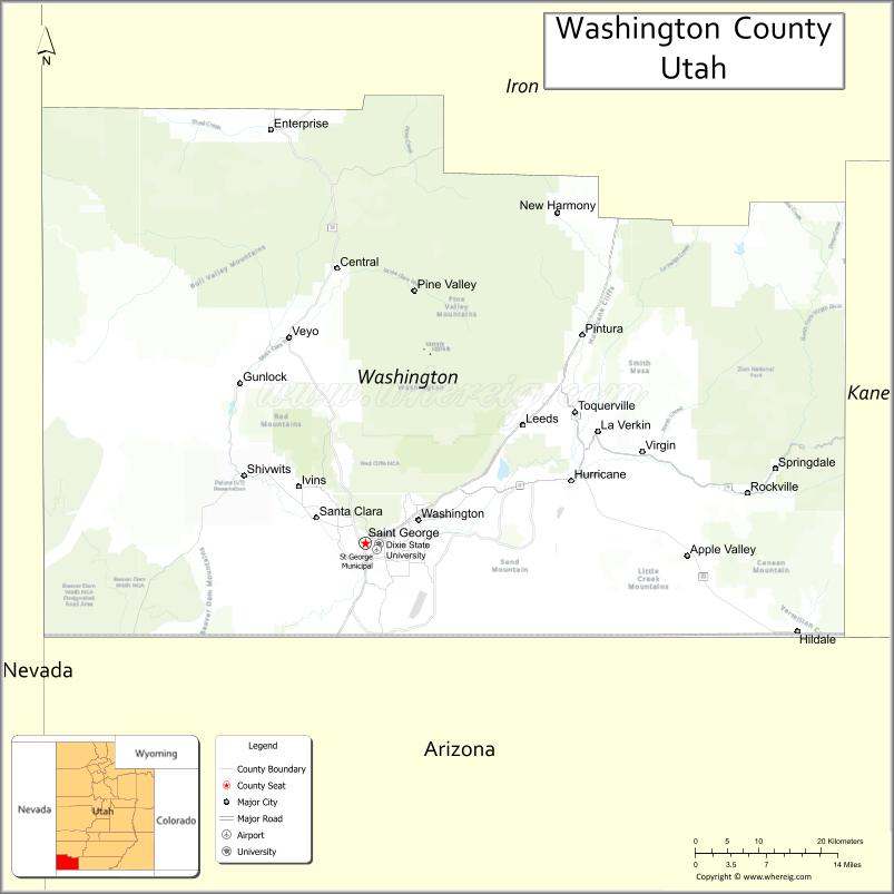
About Washington County Map, Utah: The map showing the county boundary, county seat, major cities, and neighbouring counties.
Most Viewed Links
| Utah Map | Counties in Utah | Cities in Utah |
| Utah Zipcodes | Airports in Utah | US Zip code Map |
| Utah Area Codes | Utah River Map | - |
About Washington County, Utah
Washington County is a county located in the U.S. state of Utah. Its county seat is St. George. As per the 2020 census, the population of Washington County is 191,226 people, and the population density is approximately 78.8 people per square mile. According to the United States Census Bureau, the county has a total area of 2,426 sq mi (6,283 km²). Washington County was established on October 4, 1852.
Washington County Facts
| Category | Details |
|---|---|
| County Name | Washington County |
| State | Utah |
| Country | United States |
| Region | Southwestern Utah |
| County Seat | St. George |
| Established | 1852 |
| Total Area | 2,430 sq mi (6,294 sq km) |
| Land Area | 2,426 sq mi |
| Water Area | 4 sq mi |
| Population (2020) | 180,279 |
| Population Density | ~74 persons per sq mi |
| Time Zone | Mountain Time Zone (MT) |
| Area Code | 435 |
| Nearest Airport | St. George Regional Airport |
| Famous For | Zion National Park, red rock scenery, tourism |
| Tourist Places | Zion National Park, Snow Canyon State Park, Sand Hollow State Park |
| Nearby Cities | Hurricane, UT; Ivins, UT; St. George, UT |
| FIPS Code | 49-053 |
| Official Website | washco.utah.gov |
Cities and Towns in Washington County, Utah
| City/Town | Population (2020) |
|---|---|
| St. George | 95,342 |
| Washington | 27,135 |
| Hurricane | 20,036 |
| Santa Clara | 7,841 |
| Ivins | 8,978 |
| La Verkin | 4,204 |
| Toquerville | 1,870 |
| Leeds | 865 |
| New Harmony | 207 |
| Rockville | 247 |
| Springdale | 529 |
| Enterprise | 1,812 |
| Virgin | 596 |
Top Places to Visit in Washington County, Utah
| Place | Description |
|---|---|
| Zion National Park | A stunning park with towering red cliffs, scenic hikes, and unforgettable canyon views. |
| St. George | A lively city with warm weather, parks, and a great base for exploring nearby nature. |
| Snow Canyon State Park | A beautiful desert area with lava flows, red rocks, and easy hiking trails. |
| Sand Hollow State Park | A popular spot for boating, off-roading, and relaxing by the water. |
| Red Cliffs Desert Reserve | A peaceful area with trails, wildlife, and unique desert scenery. |
| Tuacahn Amphitheatre | An outdoor theater set among red rocks, known for live shows and performances. |
| Quail Creek State Park | A calm reservoir perfect for fishing, kayaking, and enjoying the outdoors. |
| Pine Valley Mountains | A cool mountain escape with forests, trails, and scenic views. |
| Gunlock State Park | A quiet lake area known for seasonal waterfalls and peaceful surroundings. |
| Kayenta Art Village | A small creative community with galleries, shops, and a relaxed atmosphere. |
- Beaver County Map
- Box Elder County Map
- Cache County Map
- Carbon County Map
- Daggett County Map
- Davis County Map
- Duchesne County Map
- Emery County Map
- Garfield County Map
- Grand County Map
- Iron County Map
- Juab County Map
- Kane County Map
- Millard County Map
- Morgan County Map
- Piute County Map
- Rich County Map
- Salt Lake County Map
- San Juan County Map
- Sanpete County Map
- Sevier County Map
- Summit County Map
- Tooele County Map
- Uintah County Map
- Utah County Map
- Wasatch County Map
- Washington County Map
- Wayne County Map
- Weber County Map
- Alabama Counties
- Alaska boroughs
- Arizona Counties
- Arkansas Counties
- California County Map
- Colorado Counties
- Connecticut Counties
- Delaware Counties
- Florida County Map
- Georgia County Map
- Hawaii Counties
- Idaho Counties
- Illinois Counties
- Indiana Counties
- Iowa Counties
- Kansas Counties
- Kentucky Counties
- Louisiana Counties
- Maine Counties
- Maryland Counties
- Massachusetts Counties
- Michigan County Map
- Minnesota Counties
- Mississippi Counties
- Missouri Counties
- Montana Counties
- Nebraska Counties
- New Hampshire Counties
- New Jersey Counties
- New Mexico Counties
- North Carolina Counties
- North Dakota Counties
- Oklahoma Counties
- Oregon Counties
- Pennsylvania Counties
- Rhode Island Counties
- South Carolina Counties
- South Dakota Counties
- Map of Tennessee
- Texas County Map
- Utah Counties
- Vermont Counties
- Virginia Counties
- Washington Counties
- West Virginia Counties
- Wisconsin Counties
- Wyoming Counties
- Nevada Counties
- New York Counties
- Ohio County Map