Map of Iron County - Iron County is a county located in the U.S. state of Utah. Iron County Map showing cities, highways, important places and water bodies. Get Where is Iron County located in the map, major cities in Iron county, population, areas, and places of interest.
Map of Iron County, Utah
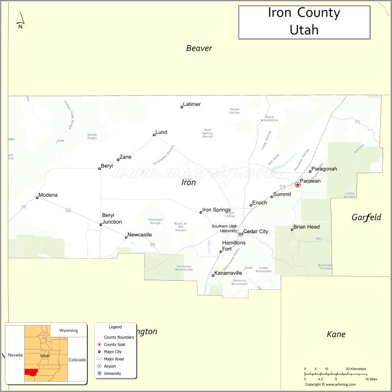
About Iron County Map, Utah: The map showing the county boundary, county seat, major cities, and neighbouring counties.
Most Viewed Links
| Utah Map | Counties in Utah | Cities in Utah |
| Utah Zipcodes | Airports in Utah | US Zip code Map |
| Utah Area Codes | Utah River Map | - |
About Iron County, Utah
Iron County is a county located in the U.S. state of Utah. Its county seat is Parowan. As per the 2020 census, the population of Iron County is 60,519 people, and the population density is approximately 18.4 people per square mile. According to the United States Census Bureau, the county has a total area of 3,297 sq mi (8,539 km²). Iron County was established on January 17, 1850.
Iron County Facts
| Category | Details |
|---|---|
| County Name | Iron County |
| State | Utah |
| Country | United States |
| Region | Southwestern Utah |
| County Seat | Parowan |
| Established | 1850 |
| Total Area | 3,302 sq mi (8,552 sq km) |
| Land Area | 3,297 sq mi |
| Water Area | 5 sq mi |
| Population (2020) | 57,289 |
| Population Density | ~17 persons per sq mi |
| Time Zone | Mountain Time Zone (MT) |
| Area Code | 435 |
| Nearest Airport | Cedar City Regional Airport |
| Famous For | Southern Utah University, red rock landscapes, outdoor recreation |
| Tourist Places | Cedar Breaks National Monument, Brian Head Resort, Parowan Gap |
| Nearby Cities | Cedar City, UT; Parowan, UT; Enoch, UT |
| FIPS Code | 49-021 |
| Official Website | ironcounty.net |
Cities and Towns in Iron County, Utah
| City/Town | Population (2020) |
|---|---|
| Cedar City | 35,235 |
| Enoch | 7,039 |
| Parowan | 3,139 |
| Paragonah | 488 |
| Kanarraville | 355 |
| Brian Head | 83 |
Top Places to Visit in Iron County, Utah
| Place | Description |
|---|---|
| Cedar Breaks National Monument | A colorful natural amphitheater with stunning views and cooler mountain air. |
| Brian Head Resort | A popular ski destination with great slopes and scenic mountain views. |
| Dixie National Forest | A peaceful forest area with trails, camping spots, and fresh mountain scenery. |
| Parowan Gap Petroglyphs | An interesting site with ancient rock carvings and a unique cultural history. |
| Frontier Homestead State Park Museum | A local museum that shares stories of early settlers and pioneer life. |
| Navajo Lake | A quiet mountain lake perfect for fishing, kayaking, or relaxing by the water. |
| Three Peaks Recreation Area | A fun outdoor area for hiking, biking, and off-road exploring. |
| Cedar City | A lively town known for festivals, shops, and a welcoming small-town feel. |
| Ashdown Gorge Wilderness | A scenic wilderness area with red rocks, forests, and peaceful hiking trails. |
| Kolob Canyons (nearby) | A less crowded part of Zion with red cliffs and quiet scenic drives. |
- Beaver County Map
- Box Elder County Map
- Cache County Map
- Carbon County Map
- Daggett County Map
- Davis County Map
- Duchesne County Map
- Emery County Map
- Garfield County Map
- Grand County Map
- Iron County Map
- Juab County Map
- Kane County Map
- Millard County Map
- Morgan County Map
- Piute County Map
- Rich County Map
- Salt Lake County Map
- San Juan County Map
- Sanpete County Map
- Sevier County Map
- Summit County Map
- Tooele County Map
- Uintah County Map
- Utah County Map
- Wasatch County Map
- Washington County Map
- Wayne County Map
- Weber County Map
- Alabama Counties
- Alaska boroughs
- Arizona Counties
- Arkansas Counties
- California County Map
- Colorado Counties
- Connecticut Counties
- Delaware Counties
- Florida County Map
- Georgia County Map
- Hawaii Counties
- Idaho Counties
- Illinois Counties
- Indiana Counties
- Iowa Counties
- Kansas Counties
- Kentucky Counties
- Louisiana Counties
- Maine Counties
- Maryland Counties
- Massachusetts Counties
- Michigan County Map
- Minnesota Counties
- Mississippi Counties
- Missouri Counties
- Montana Counties
- Nebraska Counties
- Nevada Counties
- New York Counties
- New Hampshire Counties
- New Jersey Counties
- New Mexico Counties
- North Carolina Counties
- North Dakota Counties
- Ohio County Map
- Oklahoma Counties
- Oregon Counties
- Pennsylvania Counties
- Rhode Island Counties
- South Carolina Counties
- South Dakota Counties
- Map of Tennessee
- Texas County Map
- Utah Counties
- Vermont Counties
- Virginia Counties
- Washington Counties
- West Virginia Counties
- Wisconsin Counties
- Wyoming Counties