Map of Weber County - Weber County is a county located in the U.S. state of Utah. Weber County Map showing cities, highways, important places and water bodies. Get Where is Weber County located in the map, major cities in Weber county, population, areas, and places of interest.
Map of Weber County, Utah
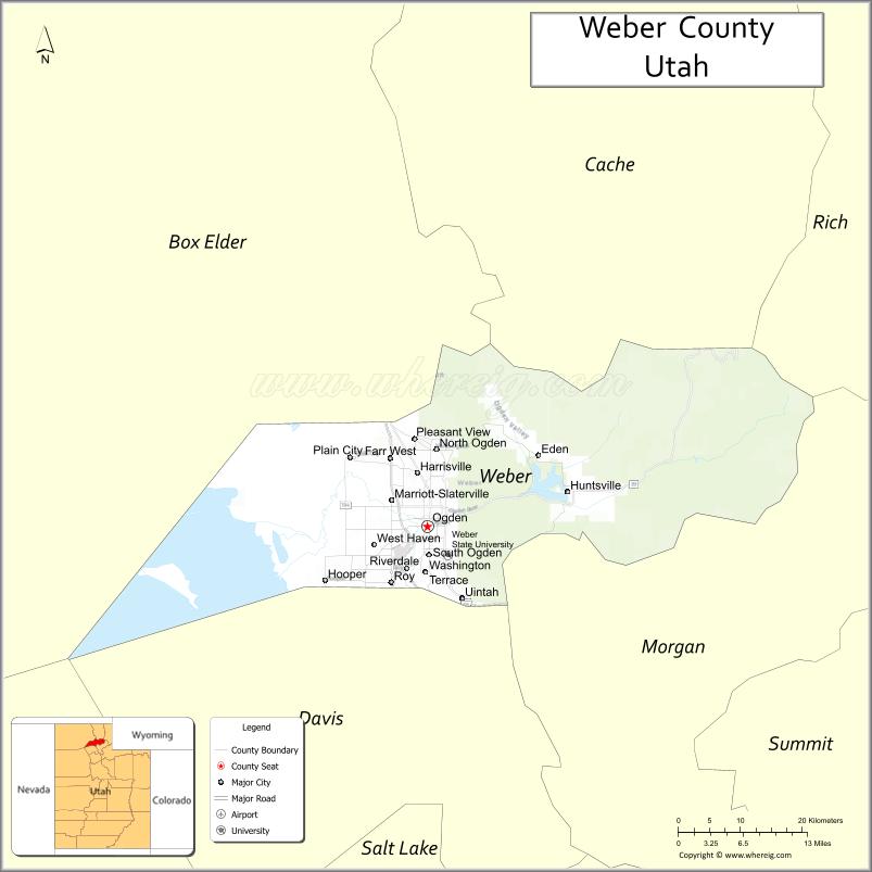
About Weber County Map, Utah: The map showing the county boundary, county seat, major cities, and neighbouring counties.
Most Viewed Links
| Utah Map | Counties in Utah | Cities in Utah |
| Utah Zipcodes | Airports in Utah | US Zip code Map |
| Utah Area Codes | Utah River Map | - |
About Weber County, Utah
Weber County is a county located in the U.S. state of Utah. Its county seat is Ogden. As per the 2020 census, the population of Weber County is 267,066 people, and the population density is approximately 464 people per square mile. According to the United States Census Bureau, the county has a total area of 576 sq mi (1,492 km²). Weber County was established on January 31, 1850.
Weber County Facts
| Category | Details |
|---|---|
| County Name | Weber County |
| State | Utah |
| Country | United States |
| Region | Northern Utah |
| County Seat | Ogden |
| Established | 1850 |
| Total Area | 659 sq mi (1,707 sq km) |
| Land Area | 576 sq mi |
| Water Area | 83 sq mi |
| Population (2020) | 262,223 |
| Population Density | ~455 persons per sq mi |
| Time Zone | Mountain Time Zone (MT) |
| Area Code | 385, 801 |
| Nearest Airport | Ogden-Hinckley Airport |
| Famous For | Ogden city, Wasatch Mountains, outdoor recreation |
| Tourist Places | Snowbasin Resort, Ogden Canyon, Pineview Reservoir |
| Nearby Cities | Salt Lake City, UT; Layton, UT; Ogden, UT |
| FIPS Code | 49-057 |
| Official Website | webercountyutah.gov |
Cities and Towns in Weber County, Utah
| City/Town | Population (2020) |
|---|---|
| Ogden | 87,321 |
| Roy | 39,306 |
| North Ogden | 20,345 |
| South Ogden | 17,395 |
| Pleasant View | 10,007 |
| Farr West | 7,029 |
| Hooper | 9,080 |
| Harrisville | 6,472 |
| West Haven | 18,616 |
| Riverdale | 8,845 |
| Marriott-Slaterville | 1,701 |
| Uintah | 1,421 |
Top Places to Visit in Weber County, Utah
| Place | Description |
|---|---|
| Ogden | A lively city with historic streets, local shops, and a gateway to outdoor adventures. |
| Snowbasin Resort | A popular mountain resort known for skiing and scenic views year-round. |
| Powder Mountain | A quieter ski area with wide slopes and fewer crowds. |
| Ogden Canyon | A scenic drive with cliffs, a river, and beautiful natural surroundings. |
| Pineview Reservoir | A peaceful lake perfect for boating, fishing, and relaxing by the water. |
| Antelope Island (part) | A nearby island with wildlife, open views, and great hiking spots. |
| Union Station | A historic building in Ogden with museums and a glimpse into the past. |
| Weber River | A calm river ideal for fishing, tubing, or simply enjoying the scenery. |
| Fort Buenaventura Park | A local park with trails, water features, and a quiet place to relax. |
| North Fork Park | A peaceful outdoor area with trails, camping spots, and year-round activities. |
- Beaver County Map
- Box Elder County Map
- Cache County Map
- Carbon County Map
- Daggett County Map
- Davis County Map
- Duchesne County Map
- Emery County Map
- Garfield County Map
- Grand County Map
- Iron County Map
- Juab County Map
- Kane County Map
- Millard County Map
- Morgan County Map
- Piute County Map
- Rich County Map
- Salt Lake County Map
- San Juan County Map
- Sanpete County Map
- Sevier County Map
- Summit County Map
- Tooele County Map
- Uintah County Map
- Utah County Map
- Wasatch County Map
- Washington County Map
- Wayne County Map
- Weber County Map
- Alabama Counties
- Alaska boroughs
- Arizona Counties
- Arkansas Counties
- California County Map
- Colorado Counties
- Connecticut Counties
- Delaware Counties
- Florida County Map
- Georgia County Map
- Hawaii Counties
- Idaho Counties
- Illinois Counties
- Indiana Counties
- Iowa Counties
- Kansas Counties
- Kentucky Counties
- Louisiana Counties
- Maine Counties
- Maryland Counties
- Massachusetts Counties
- Michigan County Map
- Minnesota Counties
- Mississippi Counties
- Missouri Counties
- Montana Counties
- Nebraska Counties
- Nevada Counties
- New York Counties
- New Hampshire Counties
- New Jersey Counties
- New Mexico Counties
- North Carolina Counties
- North Dakota Counties
- Ohio County Map
- Oklahoma Counties
- Oregon Counties
- Pennsylvania Counties
- Rhode Island Counties
- South Carolina Counties
- South Dakota Counties
- Map of Tennessee
- Texas County Map
- Utah Counties
- Vermont Counties
- Virginia Counties
- Washington Counties
- West Virginia Counties
- Wisconsin Counties
- Wyoming Counties