Map of Emery County - Emery County is a county located in the U.S. state of Utah. Emery County Map showing cities, highways, important places and water bodies. Get Where is Emery County located in the map, major cities in Emery county, population, areas, and places of interest.
Map of Emery County, Utah
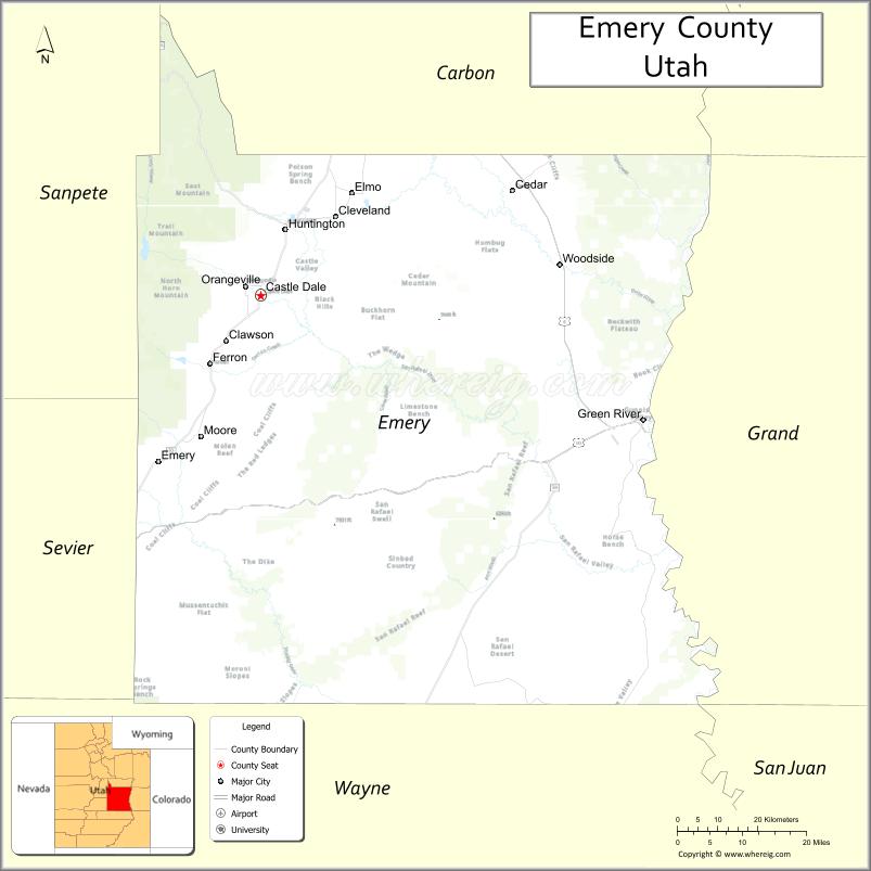
About Emery County Map, Utah: The map showing the county boundary, county seat, major cities, and neighbouring counties.
Most Viewed Links
| Utah Map | Counties in Utah | Cities in Utah |
| Utah Zipcodes | Airports in Utah | US Zip code Map |
| Utah Area Codes | Utah River Map | - |
About Emery County, Utah
Emery County is a county located in the U.S. state of Utah. Its county seat is Castle Dale. As per the 2020 census, the population of Emery County is 9,967 people, and the population density is approximately 2.2 people per square mile. According to the United States Census Bureau, the county has a total area of 4,462 sq mi (11,557 km²). Emery County was established on February 12, 1880.
Emery County Facts
| Category | Details |
|---|---|
| County Name | Emery County |
| State | Utah |
| Country | United States |
| Region | Eastern Utah |
| County Seat | Castle Dale |
| Established | 1880 |
| Total Area | 4,472 sq mi (11,583 sq km) |
| Land Area | 4,462 sq mi |
| Water Area | 10 sq mi |
| Population (2020) | 9,825 |
| Population Density | ~2 persons per sq mi |
| Time Zone | Mountain Time Zone (MT) |
| Area Code | 435 |
| Nearest Airport | Carbon County Regional Airport |
| Famous For | Coal mining, San Rafael Swell, desert landscapes |
| Tourist Places | Goblin Valley State Park, San Rafael Swell, Cleveland-Lloyd Dinosaur Quarry |
| Nearby Cities | Price, UT; Green River, UT; Castle Dale, UT |
| FIPS Code | 49-015 |
| Official Website | emerycounty.com |
Cities and Towns in Emery County, Utah
| City/Town | Population (2020) |
|---|---|
| Castle Dale | 1,492 |
| Ferron | 1,626 |
| Green River | 847 |
| Huntington | 2,101 |
| Orangeville | 1,470 |
| Cleveland | 508 |
| Clawson | 166 |
| Elmo | 452 |
Top Places to Visit in Emery County, Utah
| Place | Description |
|---|---|
| Goblin Valley State Park | A unique desert area filled with odd rock formations that look like little goblins. |
| San Rafael Swell | A rugged landscape with canyons, cliffs, and endless space for exploring. |
| Buckhorn Wash Pictograph Panel | An impressive stretch of ancient rock art that’s easy to visit and full of history. |
| Little Wild Horse Canyon | A narrow slot canyon with winding paths and smooth rock walls, great for hiking. |
| Temple Mountain | A striking desert landmark surrounded by open land and scenic views. |
| Wedge Overlook | A dramatic viewpoint often called the “Little Grand Canyon” with sweeping canyon views. |
| Green River | A calm river that runs through the area, perfect for rafting, fishing, or relaxing by the water. |
| Black Dragon Canyon | A scenic canyon known for its rock art and quiet, remote feel. |
| Swasey’s Cabin | A small historic cabin set in a peaceful desert location with a glimpse of the past. |
| Huntington State Park | A relaxing spot with a reservoir, ideal for fishing, boating, and picnics. |
- Beaver County Map
- Box Elder County Map
- Cache County Map
- Carbon County Map
- Daggett County Map
- Davis County Map
- Duchesne County Map
- Emery County Map
- Garfield County Map
- Grand County Map
- Iron County Map
- Juab County Map
- Kane County Map
- Millard County Map
- Morgan County Map
- Piute County Map
- Rich County Map
- Salt Lake County Map
- San Juan County Map
- Sanpete County Map
- Sevier County Map
- Summit County Map
- Tooele County Map
- Uintah County Map
- Utah County Map
- Wasatch County Map
- Washington County Map
- Wayne County Map
- Weber County Map
- Alabama Counties
- Alaska boroughs
- Arizona Counties
- Arkansas Counties
- California County Map
- Colorado Counties
- Connecticut Counties
- Delaware Counties
- Florida County Map
- Georgia County Map
- Hawaii Counties
- Idaho Counties
- Illinois Counties
- Indiana Counties
- Iowa Counties
- Kansas Counties
- Kentucky Counties
- Louisiana Counties
- Maine Counties
- Maryland Counties
- Massachusetts Counties
- Michigan County Map
- Minnesota Counties
- Mississippi Counties
- Missouri Counties
- Montana Counties
- Nebraska Counties
- Nevada Counties
- New York Counties
- New Hampshire Counties
- New Jersey Counties
- New Mexico Counties
- North Carolina Counties
- North Dakota Counties
- Ohio County Map
- Oklahoma Counties
- Oregon Counties
- Pennsylvania Counties
- Rhode Island Counties
- South Carolina Counties
- South Dakota Counties
- Map of Tennessee
- Texas County Map
- Utah Counties
- Vermont Counties
- Virginia Counties
- Washington Counties
- West Virginia Counties
- Wisconsin Counties
- Wyoming Counties