Map of Millard County - Millard County is a county located in the U.S. state of Utah. Millard County Map showing cities, highways, important places and water bodies. Get Where is Millard County located in the map, major cities in Millard county, population, areas, and places of interest.
Map of Millard County, Utah
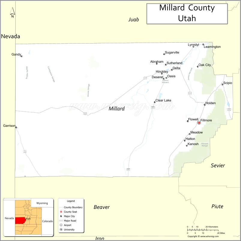
About Millard County Map, Utah: The map showing the county boundary, county seat, major cities, and neighbouring counties.
Most Viewed Links
| Utah Map | Counties in Utah | Cities in Utah |
| Utah Zipcodes | Airports in Utah | US Zip code Map |
| Utah Area Codes | Utah River Map | - |
<
About Millard County, Utah
Millard County is a county located in the U.S. state of Utah. Its county seat is Fillmore. As per the 2020 census, the population of Millard County is 13,164 people, and the population density is approximately 2.0 people per square mile. According to the United States Census Bureau, the county has a total area of 6,572 sq mi (17,021 km²). Millard County was established on October 4, 1851.
Millard County Facts
| Category | Details |
|---|---|
| County Name | Millard County |
| State | Utah |
| Country | United States |
| Region | Western Utah |
| County Seat | Fillmore |
| Established | 1851 |
| Total Area | 6,828 sq mi (17,685 sq km) |
| Land Area | 6,572 sq mi |
| Water Area | 256 sq mi |
| Population (2020) | 12,975 |
| Population Density | ~2 persons per sq mi |
| Time Zone | Mountain Time Zone (MT) |
| Area Code | 435 |
| Nearest Airport | Delta Municipal Airport |
| Famous For | Great Basin landscapes, agriculture, volcanic fields |
| Tourist Places | Great Basin Museum, Topaz Mountain, Pahvant Butte |
| Nearby Cities | Delta, UT; Fillmore, UT; Holden, UT |
| FIPS Code | 49-027 |
| Official Website | millardcounty.org |
Cities and Towns in Millard County, Utah
| City/Town | Population (2020) |
|---|---|
| Delta | 3,675 |
| Fillmore | 2,631 |
| Hinckley | 750 |
| Holden | 378 |
| Meadow | 312 |
| Oak City | 642 |
| Scipio | 366 |
Top Places to Visit in Millard County, Utah
| Place | Description |
|---|---|
| Great Basin National Park (nearby) | A beautiful park with mountain views, caves, and some of the darkest night skies around. |
| Little Sahara Recreation Area | A wide stretch of sand dunes perfect for off-roading and camping. |
| Topaz Mountain | A unique spot where visitors can search for topaz crystals in the rocky hills. |
| Fish Springs National Wildlife Refuge | A quiet wetland area known for birdwatching and peaceful surroundings. |
| Territorial Statehouse State Park Museum | A historic building that shares Utah’s early government and pioneer history. |
| Sevier Lake | A remote and dry lakebed with wide open views and a quiet desert feel. |
| Notch Peak | A striking cliff formation and one of the tallest in Utah, popular with climbers. |
| Delta City Park | A simple local park with green space and a relaxed atmosphere. |
| House Range | A rugged mountain range with scenic views and remote hiking spots. |
| Sunstone Knoll | A quiet area where visitors can look for sunstones and enjoy the open desert. |
- Beaver County Map
- Box Elder County Map
- Cache County Map
- Carbon County Map
- Daggett County Map
- Davis County Map
- Duchesne County Map
- Emery County Map
- Garfield County Map
- Grand County Map
- Iron County Map
- Juab County Map
- Kane County Map
- Millard County Map
- Morgan County Map
- Piute County Map
- Rich County Map
- Salt Lake County Map
- San Juan County Map
- Sanpete County Map
- Sevier County Map
- Summit County Map
- Tooele County Map
- Uintah County Map
- Utah County Map
- Wasatch County Map
- Washington County Map
- Wayne County Map
- Weber County Map
- Alabama Counties
- Alaska boroughs
- Arizona Counties
- Arkansas Counties
- California County Map
- Colorado Counties
- Connecticut Counties
- Delaware Counties
- Florida County Map
- Georgia County Map
- Hawaii Counties
- Idaho Counties
- Illinois Counties
- Indiana Counties
- Iowa Counties
- Kansas Counties
- Kentucky Counties
- Louisiana Counties
- Maine Counties
- Maryland Counties
- Massachusetts Counties
- Michigan County Map
- Minnesota Counties
- Mississippi Counties
- Missouri Counties
- Montana Counties
- Nebraska Counties
- Nevada Counties
- New York Counties
- New Hampshire Counties
- New Jersey Counties
- New Mexico Counties
- North Carolina Counties
- North Dakota Counties
- Ohio County Map
- Oklahoma Counties
- Oregon Counties
- Pennsylvania Counties
- Rhode Island Counties
- South Carolina Counties
- South Dakota Counties
- Map of Tennessee
- Texas County Map
- Utah Counties
- Vermont Counties
- Virginia Counties
- Washington Counties
- West Virginia Counties
- Wisconsin Counties
- Wyoming Counties