Map of Cache County - Cache County is a county located in the U.S. state of Utah. Cache County Map showing cities, highways, important places and water bodies. Get Where is Cache County located in the map, major cities in Cache county, population, areas, and places of interest.
Map of Cache County, Utah
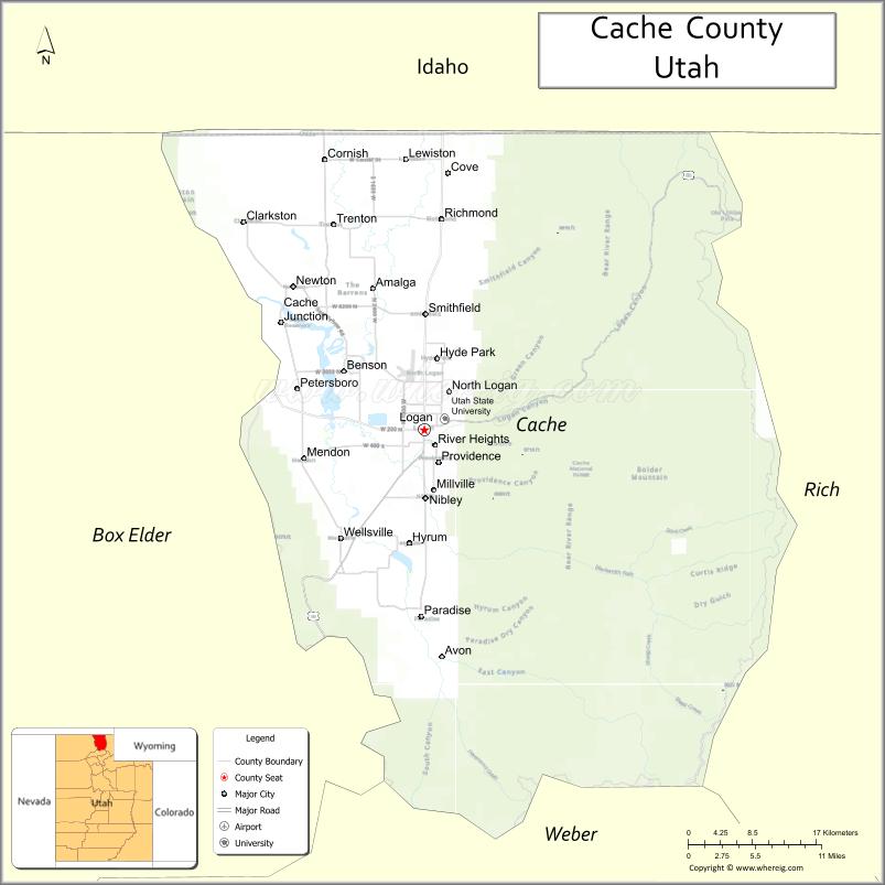
About Cache County Map, Utah: The map showing the county boundary, county seat, major cities, and neighbouring counties.
Most Viewed Links
| Utah Map | Counties in Utah | Cities in Utah |
| Utah Zipcodes | Airports in Utah | US Zip code Map |
| Utah Area Codes | Utah River Map | - |
About Cache County, Utah
Cache County is a county located in the U.S. state of Utah. Its county seat is Logan. As per the 2020 census, the population of Cache County is 137,417 people, and the population density is approximately 118 people per square mile. According to the United States Census Bureau, the county has a total area of 1,165 sq mi (3,017 km²). Cache County was established on January 5, 1856.
Cache County Facts
| Category | Details |
|---|---|
| County Name | Cache County |
| State | Utah |
| Country | United States |
| Region | Northern Utah |
| County Seat | Logan |
| Established | 1856 |
| Total Area | 1,173 sq mi (3,038 sq km) |
| Land Area | 1,165 sq mi |
| Water Area | 8 sq mi |
| Population (2020) | 133,154 |
| Population Density | ~114 persons per sq mi |
| Time Zone | Mountain Time Zone (MT) |
| Area Code | 435 |
| Nearest Airport | Logan-Cache Airport |
| Famous For | Utah State University, Cache Valley, agriculture |
| Tourist Places | Logan Canyon, Bear Lake, Hardware Ranch Wildlife Management Area |
| Nearby Cities | Logan, UT; Smithfield, UT; Hyrum, UT |
| FIPS Code | 49-005 |
| Official Website | cachecounty.gov |
Cities and Towns in Cache County, Utah
| City/Town | Population (2020) |
|---|---|
| Logan | 52,778 |
| Smithfield | 12,174 |
| North Logan | 10,985 |
| Hyde Park | 5,087 |
| Providence | 8,688 |
| Nibley | 7,356 |
| Hyrum | 8,416 |
| Wellsville | 3,857 |
| Lewiston | 1,810 |
| Richmond | 2,630 |
| River Heights | 1,734 |
| Mendon | 1,285 |
| Millville | 2,106 |
| Newton | 1,102 |
| Clarkston | 688 |
| Cornish | 273 |
| Paradise | 1,066 |
| Trenton | 688 |
| Amalga | 488 |
| Cove | 274 |
| Benson | 1,684 |
| College Ward | 820 |
Top Places to Visit in Cache County, Utah
| Place | Description |
|---|---|
| Logan Canyon Scenic Byway | A beautiful drive with river views, cliffs, and plenty of spots to stop and enjoy nature. |
| Bear Lake | A bright blue lake known for its clear water, perfect for boating, swimming, and relaxing by the shore. |
| Utah State University | A lively campus in Logan with green spaces, historic buildings, and a welcoming feel. |
| Hyrum Reservoir State Park | A calm lake area popular for fishing, boating, and easy outdoor days. |
| Wind Caves Trail | A popular hike leading to unique cave-like rock formations and great valley views. |
| Logan River | A peaceful river that runs through the canyon, great for fishing or simply enjoying the scenery. |
| Beaver Mountain Ski Area | A local favorite for skiing with a friendly atmosphere and beautiful snowy views. |
| Zootah at Willow Park | A small zoo that's fun for families, with animals and a relaxed park setting. |
| First Dam Park | A simple and scenic park near the canyon entrance, great for picnics and short walks. |
| Cache National Forest | A quiet forest area with trails, wildlife, and plenty of space to explore. |
- Beaver County Map
- Box Elder County Map
- Cache County Map
- Carbon County Map
- Daggett County Map
- Davis County Map
- Duchesne County Map
- Emery County Map
- Garfield County Map
- Grand County Map
- Iron County Map
- Juab County Map
- Kane County Map
- Millard County Map
- Morgan County Map
- Piute County Map
- Rich County Map
- Salt Lake County Map
- San Juan County Map
- Sanpete County Map
- Sevier County Map
- Summit County Map
- Tooele County Map
- Uintah County Map
- Utah County Map
- Wasatch County Map
- Washington County Map
- Wayne County Map
- Weber County Map
- Alabama Counties
- Alaska boroughs
- Arizona Counties
- Arkansas Counties
- California County Map
- Colorado Counties
- Connecticut Counties
- Delaware Counties
- Florida County Map
- Georgia County Map
- Hawaii Counties
- Idaho Counties
- Illinois Counties
- Indiana Counties
- Iowa Counties
- Kansas Counties
- Kentucky Counties
- Louisiana Counties
- Maine Counties
- Maryland Counties
- Massachusetts Counties
- Michigan County Map
- Minnesota Counties
- Mississippi Counties
- Missouri Counties
- Montana Counties
- Nebraska Counties
- Nevada Counties
- New York Counties
- New Hampshire Counties
- New Jersey Counties
- New Mexico Counties
- North Carolina Counties
- North Dakota Counties
- Ohio County Map
- Oklahoma Counties
- Oregon Counties
- Pennsylvania Counties
- Rhode Island Counties
- South Carolina Counties
- South Dakota Counties
- Map of Tennessee
- Texas County Map
- Utah Counties
- Vermont Counties
- Virginia Counties
- Washington Counties
- West Virginia Counties
- Wisconsin Counties
- Wyoming Counties