Map of Wasatch County - Wasatch County is a county located in the U.S. state of Utah. Wasatch County Map showing cities, highways, important places and water bodies. Get Where is Wasatch County located in the map, major cities in Wasatch county, population, areas, and places of interest.
Map of Wasatch County, Utah
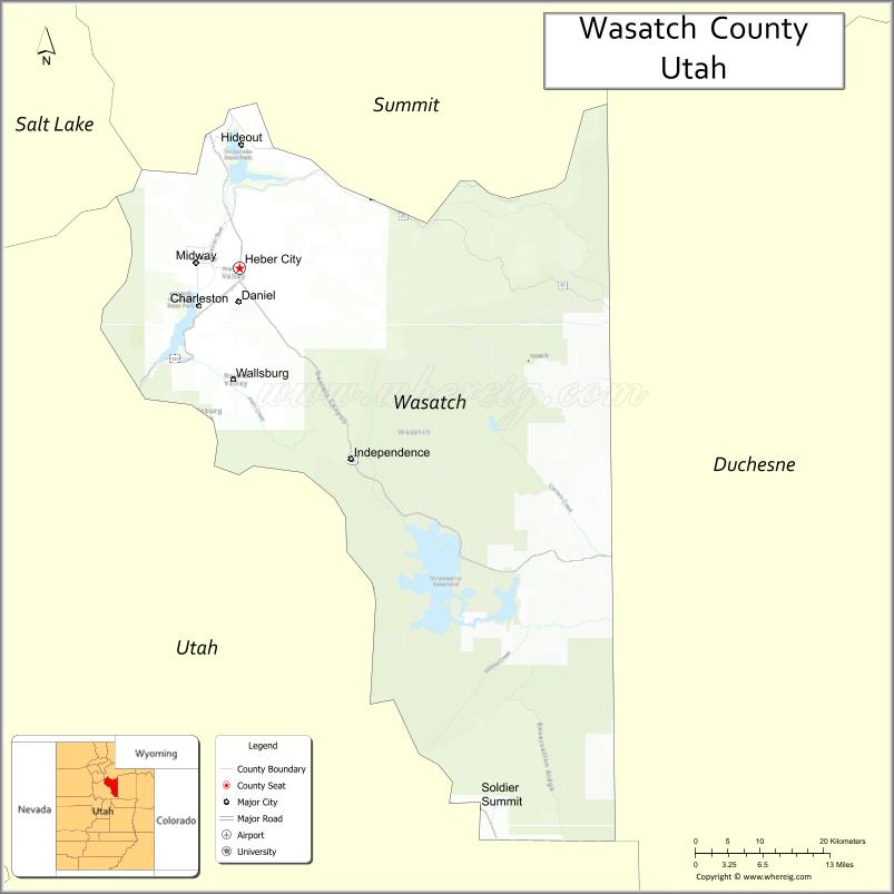
About Wasatch County Map, Utah: The map showing the county boundary, county seat, major cities, and neighbouring counties.
Most Viewed Links
| Utah Map | Counties in Utah | Cities in Utah |
| Utah Zipcodes | Airports in Utah | US Zip code Map |
| Utah Area Codes | Utah River Map | - |
About Wasatch County, Utah
Wasatch County is a county located in the U.S. state of Utah. Its county seat is Heber City. As per the 2020 census, the population of Wasatch County is 36,173 people, and the population density is approximately 30.8 people per square mile. According to the United States Census Bureau, the county has a total area of 1,176 sq mi (3,046 km²). Wasatch County was established on February 17, 1862.
Wasatch County Facts
| Category | Details |
|---|---|
| County Name | Wasatch County |
| State | Utah |
| Country | United States |
| Region | North-central Utah |
| County Seat | Heber City |
| Established | 1862 |
| Total Area | 1,206 sq mi (3,124 sq km) |
| Land Area | 1,181 sq mi |
| Water Area | 25 sq mi |
| Population (2020) | 34,788 |
| Population Density | ~29 persons per sq mi |
| Time Zone | Mountain Time Zone (MT) |
| Area Code | 435 |
| Nearest Airport | Salt Lake City International Airport |
| Famous For | Heber Valley, outdoor recreation, proximity to Park City |
| Tourist Places | Deer Creek State Park, Jordanelle State Park, Heber Valley Railroad |
| Nearby Cities | Park City, UT; Provo, UT; Heber City, UT |
| FIPS Code | 49-051 |
| Official Website | wasatch.utah.gov |
Cities and Towns in Wasatch County, Utah
| City/Town | Population (2020) |
|---|---|
| Heber City | 16,856 |
| Midway | 5,257 |
| Hideout | 1,011 |
| Wallsburg | 281 |
Top Places to Visit in Wasatch County, Utah
| Place | Description |
|---|---|
| Heber Valley | A scenic valley with wide views, open space, and a peaceful small-town feel. |
| Jordanelle State Park | A beautiful reservoir area great for boating, fishing, and relaxing by the water. |
| Deer Creek State Park | A popular lake spot with mountain views and plenty of outdoor activities. |
| Heber Valley Railroad | A fun train ride through scenic landscapes, perfect for a relaxing outing. |
| Midway | A charming town known for its alpine-style buildings and quiet atmosphere. |
| Homestead Crater | A unique geothermal spring inside a rock dome, great for soaking or swimming. |
| Wasatch Mountain State Park | A large park with trails, wildlife, and year-round outdoor activities. |
| Soldier Hollow | A scenic area used during the Olympics, now popular for skiing and outdoor fun. |
| Snake Creek Canyon | A peaceful canyon with trails, forest views, and a relaxing setting. |
| Deer Creek Reservoir | A calm lake with beautiful views, perfect for water activities and picnics. |
- Beaver County Map
- Box Elder County Map
- Cache County Map
- Carbon County Map
- Daggett County Map
- Davis County Map
- Duchesne County Map
- Emery County Map
- Garfield County Map
- Grand County Map
- Iron County Map
- Juab County Map
- Kane County Map
- Millard County Map
- Morgan County Map
- Piute County Map
- Rich County Map
- Salt Lake County Map
- San Juan County Map
- Sanpete County Map
- Sevier County Map
- Summit County Map
- Tooele County Map
- Uintah County Map
- Utah County Map
- Wasatch County Map
- Washington County Map
- Wayne County Map
- Weber County Map
- Alabama Counties
- Alaska boroughs
- Arizona Counties
- Arkansas Counties
- California County Map
- Colorado Counties
- Connecticut Counties
- Delaware Counties
- Florida County Map
- Georgia County Map
- Hawaii Counties
- Idaho Counties
- Illinois Counties
- Indiana Counties
- Iowa Counties
- Kansas Counties
- Kentucky Counties
- Louisiana Counties
- Maine Counties
- Maryland Counties
- Massachusetts Counties
- Michigan County Map
- Minnesota Counties
- Mississippi Counties
- Missouri Counties
- Montana Counties
- Nebraska Counties
- Nevada Counties
- New York Counties
- New Hampshire Counties
- New Jersey Counties
- New Mexico Counties
- North Carolina Counties
- North Dakota Counties
- Ohio County Map
- Oklahoma Counties
- Oregon Counties
- Pennsylvania Counties
- Rhode Island Counties
- South Carolina Counties
- South Dakota Counties
- Map of Tennessee
- Texas County Map
- Utah Counties
- Vermont Counties
- Virginia Counties
- Washington Counties
- West Virginia Counties
- Wisconsin Counties
- Wyoming Counties