Map of Wayne County - Wayne County is a county located in the U.S. state of Utah. Wayne County Map showing cities, highways, important places and water bodies. Get Where is Wayne County located in the map, major cities in Wayne county, population, areas, and places of interest.
Map of Wayne County, Utah
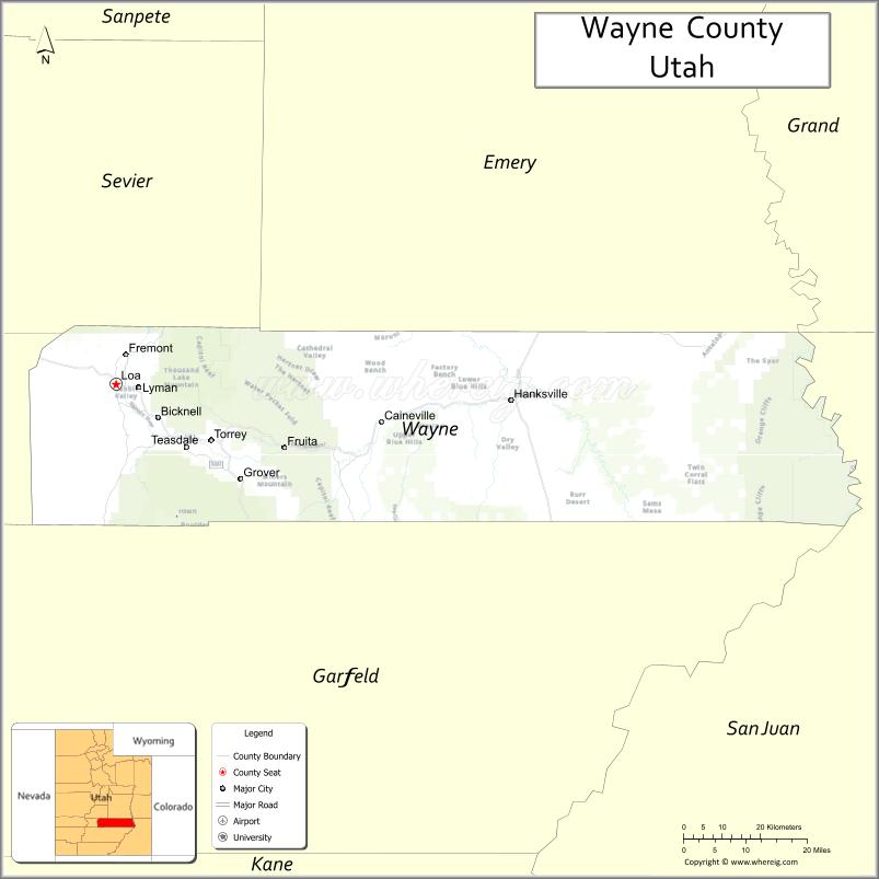
About Wayne County Map, Utah: The map showing the county boundary, county seat, major cities, and neighbouring counties.
Most Viewed Links
| Utah Map | Counties in Utah | Cities in Utah |
| Utah Zipcodes | Airports in Utah | US Zip code Map |
| Utah Area Codes | Utah River Map | - |
About Wayne County, Utah
Wayne County is a county located in the U.S. state of Utah. It's county seat is Loa. As per 2020 census, the population of Wayne County is 2558 people and population density is square miles. According to the United States Census Bureau, the county has a total area of 2,461 sq mi (6,374 km2). Wayne County was established on -2851.
Wayne County Facts
| County Info | Facts |
|---|---|
| County | Wayne County |
| County Seat | Loa |
| State | Utah |
| Country | United States |
| FIPS code | 55 |
| Established | -2851 |
| Area | 2,461 sq mi (6,374 km2) |
| Population | 2558 |
| Density | |
| Formed / Origin | Part of Piute County |
Explore Map of Utah Counties
- Beaver County Map
- Box Elder County Map
- Cache County Map
- Carbon County Map
- Daggett County Map
- Davis County Map
- Duchesne County Map
- Emery County Map
- Garfield County Map
- Grand County Map
- Iron County Map
- Juab County Map
- Kane County Map
- Millard County Map
- Morgan County Map
- Piute County Map
- Rich County Map
- Salt Lake County Map
- San Juan County Map
- Sanpete County Map
- Sevier County Map
- Summit County Map
- Tooele County Map
- Uintah County Map
- Utah County Map
- Wasatch County Map
- Washington County Map
- Wayne County Map
- Weber County Map
County Map of U.S. 50 States
- Alabama Counties
- Alaska boroughs
- Arizona Counties
- Arkansas Counties
- California County Map
- Colorado Counties
- Connecticut Counties
- Delaware Counties
- Florida County Map
- Georgia County Map
- Hawaii Counties
- Idaho Counties
- Illinois Counties
- Indiana Counties
- Iowa Counties
- Kansas Counties
- Kentucky Counties
- Louisiana Counties
- Maine Counties
- Maryland Counties
- Massachusetts Counties
- Michigan County Map
- Minnesota Counties
- Mississippi Counties
- Missouri Counties
- Montana Counties
- Nebraska Counties
- New Hampshire Counties
- New Jersey Counties
- New Mexico Counties
- North Carolina Counties
- North Dakota Counties
- Oklahoma Counties
- Oregon Counties
- Pennsylvania Counties
- Rhode Island Counties
- South Carolina Counties
- South Dakota Counties
- Map of Tennessee
- Texas County Map
- Utah Counties
- Vermont Counties
- Virginia Counties
- Washington Counties
- West Virginia Counties
- Wisconsin Counties
- Wyoming Counties
- Nevada Counties
- New York Counties
- Ohio County Map