
Where is Kaysville Located? - Kaysville is a city located in the Davis County of Utah, United States. Kaysville lies between 35.9828412 Degrees North latitudes and 86.5186045 Degrees West longitudes.
Location Map of Kaysville, Utah
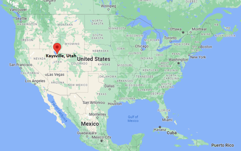
Kaysville Map, Utah, USA
Where is Kaysville?: The Google Map showing the location of Kaysville in the U.S. state of Utah.
Where is Kaysville Located?
Kaysville is a city located in the Davis County of Utah, United States. Kaysville lies between 35.9828412 Degrees North latitudes and 86.5186045 Degrees West longitudes. According to 2020 U.S.census, the population of Kaysville city is 32945 people and the city has a total area of 10.5 sq mi. The city has numerous parks and recreational facilities.
Most Viewed US Maps
| USA Sttae Map | USA Region Map | USA Road Map |
| USA County Map | Where is USA in World Map? | US ZIP Code Map |
| USA Time Zones Map | US State and Capitals Map | USA Physical Map |
Find 4,400+ U.S. Cities by State - Explore Their Locations and Get Detailed Information
Kaysville, Utah Quick Facts
| Property | Details |
|---|---|
| City | Kaysville |
| County | Davis County |
| State | Utah |
| State Capital | Salt Lake City |
| US Region | West |
| Latitude | 41.0352° N |
| Longitude | 111.9388° W |
| Elevation | 4,422 ft (1,348 m) |
| Land Area | 10.57 sq mi |
| Water Area | 0.02 sq mi |
| Total Area | 10.59 sq mi |
| Population (2020 Census) | 32,945 |
| Population Density | About 3,117 per sq mi |
| ZIP Code | 84037 |
| Area Code | 385 and 801 |
| Time Zone Standard | Mountain Standard Time (MST, UTC−07:00) |
| Time Zone Daylight | Mountain Daylight Time (MDT, UTC−06:00) |
| Currency | United States Dollar (USD) |
| FIPS Code | 49-40660 |
| Congressional District | 1st Congressional District |
Transportation and Connectivity in Kaysville
| Category | Details |
|---|---|
| Airport Name | Salt Lake City International Airport |
| IATA Code | SLC |
| Port | No commercial seaport; Great Salt Lake marinas nearby |
| Major Highways | Interstate 15, U.S. Route 89, State Route 273 (Main Street) |
| Train Service | UTA FrontRunner commuter rail (nearby Farmington Station) |
| Local Bus/Transit Service | Utah Transit Authority (UTA) bus service |
- Interstate 15 provides direct access to Salt Lake City, Ogden, and northern Utah communities.
- U.S. Route 89 runs through eastern Kaysville and connects the city with the Wasatch Front region.
- Salt Lake City International Airport is approximately 25 miles south of Kaysville.
- UTA FrontRunner commuter rail stations in nearby Farmington and Layton provide convenient regional rail service.
- UTA bus routes connect Kaysville with neighboring cities and employment centers throughout Davis County.
Top Places to Visit in Kaysville, Utah
| Landmark Name | Type |
|---|---|
| USU Botanical Center | Botanical Garden |
| Barnes Park | Community Park |
| Cherry Hill Water Park | Water Park & Campground |
| Kaysville Theatre | Historic Theater |
| Heritage Park | City Park |
| Adams Canyon Trail | Hiking Trail |
| Great Salt Lake Shorelands Preserve | Nature Preserve |
| Boondocks Food & Fun | Family Entertainment Center |
| Davis Creek Trail | Recreation Trail |
| Ellison Park | Neighborhood Park |
Driving Distances from Kaysville, Utah to Nearby Cities
| City | State | Distance (mi) | Approx. Drive Time |
|---|---|---|---|
| Farmington | Utah | 4 | 8 min |
| Layton | Utah | 5 | 10 min |
| Fruit Heights | Utah | 3 | 6 min |
| Centerville | Utah | 9 | 15 min |
| Bountiful | Utah | 15 | 20 min |
| Ogden | Utah | 18 | 25 min |
| Salt Lake City | Utah | 23 | 30 min |
| Syracuse | Utah | 12 | 20 min |
| Clearfield | Utah | 9 | 15 min |
| Logan | Utah | 67 | 1 hr 10 min |
Colleges and Universities in Kaysville, Utah
| Institution Name | Type | Level | Notable For |
|---|---|---|---|
| Utah State University Kaysville | Public | University Extension Campus | Agricultural research, extension services, and the USU Botanical Center |
| Weber State University | Public | University | Comprehensive undergraduate and graduate degree programs |
| Davis Technical College | Public | Technical College | Career and technical education, workforce development, and certification programs |
| University of Utah | Public | University | Research, professional, and graduate education |
| Salt Lake Community College | Public | Community College | Associate degrees, workforce training, and university transfer programs |
Waterbodies in Kaysville, Utah
Kaysville lies between the Wasatch Mountains and the Great Salt Lake. Important nearby water features include Kays Creek, Holmes Creek, Farmington Creek, the Great Salt Lake, Farmington Bay, Davis Creek Reservoir, and several irrigation canals that support agriculture and recreation throughout Davis County.
Golf Courses in Kaysville
Golfers in and around Kaysville can enjoy several nearby courses, including Davis Golf Course, Valley View Golf Course, Schneiter's Bluff Golf Course, Lakeside Golf Course, Hubbard Memorial Golf Course, and Eaglewood Golf Course.
Kaysville, Utah — Key Historical Facts
- Kaysville was first settled by Mormon pioneers in 1847 and was named after early settler William Kay.
- The community developed as an agricultural center, with fruit orchards, livestock farming, and grain production playing important roles in its economy.
- Kaysville was officially incorporated in 1868, making it one of the oldest incorporated municipalities in Utah.
- The arrival of rail transportation and later Interstate 15 contributed to steady residential and commercial growth throughout the twentieth century.
- Today, Kaysville is known for its excellent schools, family-friendly neighborhoods, outdoor recreation, and convenient location along Utah's Wasatch Front.
References
- City of Kaysville
- U.S. Census Bureau – Kaysville City QuickFacts
- Utah State University Extension
- Visit Utah
- Davis County Government
Utah Related Maps and Info
| Utah Map | Counties in Utah | Cities in Utah |
| Utah Zipcodes | Airports in Utah | US Zip code Map |
| Utah Area Codes | Utah River Map | - |
- Where is American Fork
- Where is Bluffdale
- Where is Bountiful
- Where is Brigham City
- Where is Cedar City
- Where is Centerville
- Where is Clearfield
- Where is Clinton
- Where is Cottonwood Heights
- Where is Draper
- Where is Eagle Mountain
- Where is Farmington
- Where is Heber
- Where is Herriman
- Where is Highland
- Where is Holladay
- Where is Hurricane
- Where is Kaysville
- Where is Layton
- Where is Lehi
- Where is Logan
- Where is Midvale
- Where is Murray
- Where is North Ogden
- Where is North Salt Lake
- Where is Ogden
- Where is Orem
- Where is Payson
- Where is Pleasant Grove
- Where is Provo
- Where is Riverton
- Where is Roy
- Where is Sandy
- Where is Santaquin
- Where is Saratoga Springs
- Where is South Jordan
- Where is South Ogden
- Where is South Salt Lake
- Where is Spanish Fork
- Where is Springville
- Where is St. George
- Where is Syracuse
- Where is Taylorsville
- Where is Tooele
- Where is Vineyard
- Where is Washington
- Where is West Haven
- Where is West Jordan
- Where is West Valley City