
Where is Costa Mesa, California Located in the United States? - Costa Mesa is a city located in the Orange County in California, United States. Costa Mesa lies between 33.6411 Degrees North latitudes and -117.9187 Degrees West longitudes.
Location Map of Costa Mesa, Orange, California
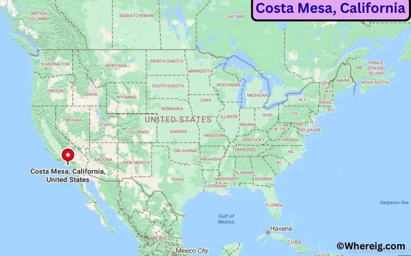
About Map: The map shows the location of Costa Mesa in Orange County, in the U.S. state of California.
Costa Mesa Map, California, USA
About Costa Mesa Map: This Google Map provides a detailed view with zoom, satellite, and street options to explore the area and its surroundings.
About Costa Mesa, Orange County, California
Costa Mesa is located in Orange County in the U.S. state of California, United States. It lies in the southern part of the state in the state of the United States near the Pacific coast of Southern California. The city was incorporated in 1953 and was named using Spanish words meaning “coastal tableland,” and it has developed into a major commercial and cultural center within Orange County.
Population
According to the United States Census Bureau, the population of Costa Mesa is 111,918 as recorded in the 2020 Census, and the population density is approximately 7,200 people per square mile.
Geography
According to the United States Census Bureau, Costa Mesa covers a total area of approximately 16.0 square miles (about 41.4 square kilometers), including about 15.8 square miles (40.9 square kilometers) of land and 0.2 square miles (0.5 square kilometers) of water.
Location and Surroundings
Costa Mesa is situated south of Santa Ana and northeast of Newport Beach, positioned within the Los Angeles metropolitan area. The city features a mix of residential neighborhoods, commercial districts, and open spaces, with relatively flat terrain and proximity to coastal environments. Major highways including Interstate 405, State Route 55, and State Route 73 provide convenient regional connectivity.
Top Attractions
Costa Mesa offers a range of cultural, shopping, and recreational destinations that attract visitors from across the region. Notable attractions include South Coast Plaza, the Segerstrom Center for the Arts, and Fairview Park. The city is also home to Orange Coast College, contributing to higher education and workforce development in the area.
Transportation
Costa Mesa is served by Interstate 405 and several state routes, providing direct access to neighboring cities and regional employment centers. Public transportation includes bus services operated by the Orange County Transportation Authority connecting to surrounding communities. The nearest major airport is John Wayne Airport, located approximately 5 miles to the east.
Explore more cities in California or visit the United States Map section to learn more about the country’s geography.
Sources:
Population and area data sourced from the United States Census Bureau (2020 Census). General city information referenced from the Official Costa Mesa City Website.
Most Viewed US Maps
| USA Sttae Map | USA Region Map | USA Road Map |
| USA County Map | Where is USA in World Map? | US ZIP Code Map |
| USA Time Zones Map | US State and Capitals Map | USA Physical Map |
Find 4,400+ U.S. Cities by State - Explore Their Locations and Get Detailed Information
Costa Mesa City Facts
| City | Costa Mesa |
| State | California |
| County | Orange County |
| Country | United States |
| Region | Southern California - Orange County |
| Incorporated | June 29, 1953 |
| Founded | 1889 |
| Total Area | Approximately 15.7 sq mi (40.7 km2) |
| Land Area | Approximately 15.7 sq mi (40.7 km2) |
| Water Area | Approximately 0.0 sq mi (0.0 km2) |
| Elevation | Approximately 98 ft (30 m) |
| Population (2023 estimate) | Approximately 113,000+ |
| Population (2020 Census) | 111,918 |
| Population Density | Approximately 7,100 people per sq mi |
| Time Zone | Pacific Time (UTC-8 / UTC-7 DST) |
| ZIP Codes | 92626, 92627, 92628 |
| Area Code | 714, 657 |
| Major Highways | State Route 55, State Route 73, Interstate 405 nearby |
| Public Transit | Orange County Transportation Authority Bus Service |
| Major Attractions | South Coast Plaza, Orange County Museum of Art, Fairview Park |
| Official Website | https://www.costamesaca.gov/ |
Distance from Costa Mesa City, CA to Nearby Cities in California
- Newport Beach, CA – 5 miles (8 km)
- Santa Ana, CA – 7 miles (11 km)
- Irvine, CA – 10 miles (16 km)
- Huntington Beach, CA – 10 miles (16 km)
- Anaheim, CA – 15 miles (24 km)
- Garden Grove, CA – 12 miles (19 km)
- Long Beach, CA – 23 miles (37 km)
- Fullerton, CA – 18 miles (29 km)
- Orange, CA – 10 miles (16 km)
- Seal Beach, CA – 15 miles (24 km)
- Tustin, CA – 9 miles (14 km)
- Laguna Beach, CA – 18 miles (29 km)
- San Clemente, CA – 30 miles (48 km)
- Los Angeles, CA – 40 miles (64 km)
- Torrance, CA – 28 miles (45 km)
- Ontario, CA – 35 miles (56 km)
- Riverside, CA – 45 miles (72 km)
- Corona, CA – 30 miles (48 km)
- Pasadena, CA – 45 miles (72 km)
- San Bernardino, CA – 55 miles (89 km)
Costa Mesa, California Climate and Weather Overview
| Month | Avg High (°F) | Avg Low (°F) | Avg Rainfall (in) |
|---|---|---|---|
| January | 68 | 48 | 2.8 |
| April | 70 | 52 | 0.7 |
| July | 82 | 64 | 0.1 |
| October | 76 | 58 | 0.6 |
| Annual | 74 | 56 | 12.0 |
| Climate Attribute | Value |
|---|---|
| Climate Classification (Köppen) | Mediterranean (Csa) |
| Annual Rainfall | ~12 inches |
| Annual Sunshine Days | ~280 days |
| Tornado Risk | Very Low |
| Snowfall | Rare (0 inches typical) |
Driving Distances from Costa Mesa, California
| City | State | Distance (mi) | Approx. Drive Time |
|---|---|---|---|
| Newport Beach | CA | 3 | 10 min |
| Irvine | CA | 6 | 12 min |
| Huntington Beach | CA | 7 | 15 min |
| Santa Ana | CA | 4 | 10 min |
| Anaheim | CA | 12 | 20 min |
| Long Beach | CA | 22 | 30 min |
| Los Angeles | CA | 40 | 45 min |
| Laguna Beach | CA | 12 | 20 min |
| Fountain Valley | CA | 6 | 12 min |
| San Diego | CA | 85 | 1 hr 30 min |
Transportation and Connectivity in Costa Mesa, California
| Mode | Details |
|---|---|
| Airport | John Wayne Airport (SNA), Long Beach Airport (LGB), LAX nearby |
| Port | Port of Long Beach / Port of Los Angeles |
| Major Highways | I-405, SR-55, SR-73, SR-1 (Pacific Coast Highway nearby) |
| Rail/Amtrak | Amtrak service via Irvine and Santa Ana stations |
| Local Transit | Orange County Transportation Authority (OCTA) |
- I-405 - major north-south freeway connecting Costa Mesa with Los Angeles and San Diego routes
- SR-55 - connects Costa Mesa to inland Orange County including Irvine
- SR-73 - toll road linking coastal Orange County communities
Key Landmarks and Places to Visit in Costa Mesa, California
| Landmark Name | Type |
|---|---|
| South Coast Plaza | Shopping Center |
| Segerstrom Center for the Arts | Performing Arts Center |
| Costa Mesa Art Walk | Cultural Event District |
| Fairview Park | Nature Park |
| OC Fair & Event Center | Event Venue |
| TeWinkle Park | Community Park |
| Back Bay Loop Trail (nearby) | Nature Trail |
| Upper Newport Bay Nature Preserve | Nature Preserve |
Places to Visit in Costa Mesa, California
| Landmark Name | Type |
|---|---|
| South Coast Plaza | Retail Destination |
| Segerstrom Center for the Arts | Performing Arts |
| OC Fair & Event Center | Fairgrounds |
| Fairview Park | Nature Park |
| Metro Pointe at South Coast | Shopping Center |
| Newport Back Bay | Ecological Reserve |
| TeWinkle Park | Recreation Park |
| Orange Coast College Planetarium | Educational Attraction |
Colleges and Universities in Costa Mesa, California
| Institution Name | Type | Level | Notable For |
|---|---|---|---|
| Orange Coast College | Public | Community College | Marine science & transfer programs |
| California State University, Fullerton (nearby) | Public | University | Business & liberal arts |
| University of California, Irvine (nearby) | Public | University | Research & STEM programs |
Waterbodies in Costa Mesa, California
Newport Bay, Santa Ana River, Upper Newport Bay Ecological Reserve, Talbert Channel, Pacific Ocean (nearby coastline)
Golf Courses in Costa Mesa, California
Costa Mesa Country Club, Mesa Verde Country Club, Tustin Ranch Golf Club (nearby), Newport Beach Golf Course (nearby)
Costa Mesa, California - Key Historical Facts
- Costa Mesa developed as a farming community in the early 20th century, primarily focused on sheep grazing and crops.
- The city was incorporated in 1953 as Orange County experienced rapid suburban expansion.
- Its name means “coastal tableland” in Spanish, reflecting its elevated coastal plateau geography.
- The opening of South Coast Plaza in the 1960s transformed the city into a major retail and commercial hub.
- Costa Mesa grew alongside nearby Newport Beach and Irvine as part of Southern California’s suburban boom.
- Today, it is known for arts, shopping, and its central location in Orange County.
References
- City of Costa Mesa Official Website
- U.S. Census Bureau
- South Coast Plaza Official Site
- Visit Orange County
California Related Links
- Where is Adelanto
- Where is Alameda
- Where is Alhambra
- Where is Aliso Viejo
- Where is Antioch
- Where is Apple Valley
- Where is Arcadia
- Where is Atascadero
- Where is Atwater
- Where is Azusa
- Where is Baldwin Park
- Where is Banning
- Where is Barstow
- Where is Beaumont
- Where is Bell Gardens
- Where is Bell
- Where is Bellflower
- Where is Belmont
- Where is Benicia
- Where is Beverly Hills
- Where is Brawley
- Where is Brea
- Where is Brentwood
- Where is Buena Park
- Where is Burbank
- Where is Burlingame
- Where is Calexico
- Where is Camarillo
- Where is Campbell
- Where is Carlsbad
- Where is Carson
- Where is Cathedral City
- Where is Ceres
- Where is Cerritos
- Where is Chico
- Where is Chino Hills
- Where is Chino
- Where is Citrus Heights
- Where is Claremont
- Where is Coachella
- Where is Colton
- Where is Compton
- Where is Concord
- Where is Costa Mesa
- Where is Covina
- Where is Culver City
- Where is Cupertino
- Where is Cypress
- Where is Daly City
- Where is Dana Point
- Where is Danville
- Where is Davis
- Where is Delano
- Where is Desert Hot Springs
- Where is Diamond Bar
- Where is Downey
- Where is Dublin
- Where is East Palo Alto
- Where is Eastvale
- Where is El Cajon
- Where is El Centro
- Where is El Cerrito
- Where is El Monte
- Where is Encinitas
- Where is Eureka
- Where is Fairfield
- Where is Folsom
- Where is Foster City
- Where is Fountain Valley
- Where is Galt
- Where is Gardena
- Where is Gilroy
- Where is Glendora
- Where is Goleta
- Where is Hanford
- Where is Hawthorne
- Where is Hemet
- Where is Hercules
- Where is Hesperia
- Where is Highland
- Where is Hollister
- Where is Huntington Park
- Where is Imperial Beach
- Where is Indio
- Where is Inglewood
- Where is Jurupa Valley
- Where is La Habra
- Where is La Mesa
- Where is La Mirada
- Where is La Puente
- Where is La Quinta
- Where is La Verne
- Where is Lafayette
- Where is Laguna Hills
- Where is Laguna Niguel
- Where is Lake Elsinore
- Where is Lake Forest
- Where is Lakewood
- Where is Lathrop
- Where is Lawndale
- Where is Lemon Grove
- Where is Lemoore
- Where is Lincoln
- Where is Livermore
- Where is Lodi
- Where is Lompoc
- Where is Los Altos
- Where is Los Banos
- Where is Los Gatos
- Where is Lynwood
- Where is Madera
- Where is Manhattan Beach
- Where is Manteca
- Where is Martinez
- Where is Maywood
- Where is Menifee
- Where is Menlo Park
- Where is Merced
- Where is Milpitas
- Where is Mission Viejo
- Where is Monrovia
- Where is Montclair
- Where is Montebello
- Where is Monterey
- Where is Monterey Park
- Where is Moorpark
- Where is Morgan Hill
- Where is Mountain View
- Where is Murrieta
- Where is Napa
- Where is National City
- Where is Newark
- Where is Newport Beach
- Where is Norco
- Where is Norwalk
- Where is Novato
- Where is Oakley
- Where is Pacifica
- Where is Palm Desert
- Where is Palm Springs
- Where is Palo Alto
- Where is Paramount
- Where is Paso Robles
- Where is Perris
- Where is Petaluma
- Where is Pico Rivera
- Where is Pittsburg
- Where is Placentia
- Where is Pleasant Hill
- Where is Pleasanton
- Where is Porterville
- Where is Poway
- Where is Rancho Cordova
- Where is Rancho Palos Verdes
- Where is Rancho Santa Margarita
- Where is Redding
- Where is Redlands
- Where is Redondo Beach
- Where is Redwood City
- Where is Reedley
- Where is Rialto
- Where is Richmond
- Where is Ridgecrest
- Where is Rocklin
- Where is Rohnert Park
- Where is Rosemead
- Where is San Bruno
- Where is San Carlos
- Where is San Clemente
- Where is San Dimas
- Where is San Gabriel
- Where is San Jacinto
- Where is San Juan Capistrano
- Where is San Leandro
- Where is San Luis Obispo
- Where is San Marcos
- Where is San Mateo
- Where is San Pablo
- Where is San Rafael
- Where is San Ramon
- Where is Sanger
- Where is Santa Barbara
- Where is Santa Cruz
- Where is Santa Maria
- Where is Santa Monica
- Where is Santa Paula
- Where is Santee
- Where is Saratoga
- Where is Seal Beach
- Where is Seaside
- Where is Simi Valley
- Where is South Gate
- Where is South Pasadena
- Where is South San Francisco
- Where is Stanton
- Where is Suisun City
- Where is Temecula
- Where is Temple City
- Where is Tracy
- Where is Tulare
- Where is Turlock
- Where is Tustin
- Where is Twentynine Palms
- Where is Union City
- Where is Upland
- Where is Vacaville
- Where is Ventura
- Where is Vista
- Where is Walnut Creek
- Where is Walnut
- Where is Wasco
- Where is Watsonville
- Where is West Covina
- Where is West Hollywood
- Where is West Sacramento
- Where is Westminster
- Where is Whittier
- Where is Wildomar
- Where is Windsor
- Where is Woodland
- Where is Yorba Linda
- Where is Yuba City
- Where is Yucaipa