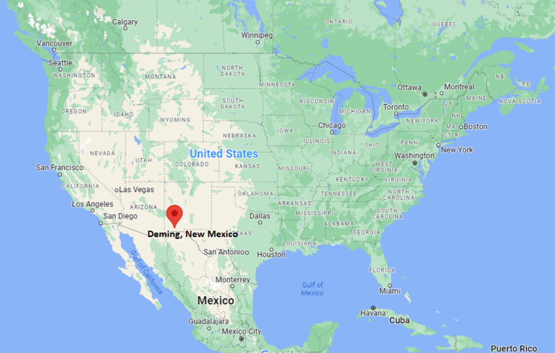
Where is Deming Located? - Deming is a city located in the Luna County of New Mexico, United States. Deming lies between 38.6201125 Degrees North latitudes and 75.1507399 Degrees West longitudes.
Location Map of Deming, New Mexico
Deming Map, New Mexico, USA
Where is Deming?: The Google Map showing the location of Deming in the U.S. state of New Mexico.
Where is Deming Located?
Deming is a city located in the Luna County of New Mexico, United States. Deming lies between 38.6201125 Degrees North latitudes and 75.1507399 Degrees West longitudes. According to 2020 U.S.census, the population of Deming city is 14758 people and the city has a total area of 16.7 sq mi. The city has numerous parks and recreational facilities.
Truth or Consequences, New Mexico - Northeast - 117 mi
Alamogordo, New Mexico - East - 132 mi
El Paso, Texas - Southeast - 104 mi
Willcox, Arizona - West - 95 mi
Benson, Arizona - West - 135 mi
Douglas, Arizona - Southwest - 113 mi
Deming, New Mexico Climate and Weather Overview
Month
Avg High (°F)
Avg Low (°F)
Avg Rainfall (in)
January
58
27
0.5
April
80
46
0.3
July
94
69
2.1
October
81
48
0.9
Annual
78
47
10.2
Climate Attribute
Details
Climate Classification (Köppen)
Cold Desert (BWk)
Annual Rainfall
About 10 inches
Annual Sunshine Days
Approximately 293 days
Hurricane/Tornado Risk
Very low hurricane risk; low tornado risk
Snowfall
About 2 inches annually
Driving Distances from Deming, New Mexico
City
State
Distance (mi)
Approx. Drive Time
Columbus
New Mexico
32
35 min
Silver City
New Mexico
58
1 hr
Lordsburg
New Mexico
60
1 hr
Las Cruces
New Mexico
61
1 hr
Willcox
Arizona
95
1 hr 30 min
El Paso
Texas
104
1 hr 40 min
Douglas
Arizona
113
1 hr 50 min
Truth or Consequences
New Mexico
117
1 hr 50 min
Alamogordo
New Mexico
132
2 hr
Benson
Arizona
135
2 hr 5 min
Transportation and Connectivity in Deming, New Mexico
Transportation
Details
Airport Name
Deming Municipal Airport
IATA Code
DMN
Port
No commercial port
Major Highways
Interstate 10, US Route 180, New Mexico State Road 11, New Mexico State Road 26
Train/Amtrak Service
No passenger rail service; freight rail operated by Union Pacific
Local Bus/Transit Service
Luna County public transportation and regional shuttle services
Interstate 10 - Major east-west interstate connecting Deming with Las Cruces, El Paso, Tucson, and Phoenix.
US Route 180 - Connects Deming with Silver City, western New Mexico, and southeastern Arizona.
New Mexico State Road 11 - Runs south from Deming to Columbus and the U.S.-Mexico border.
New Mexico State Road 26 - Scenic highway linking Deming with Hatch and Interstate 25 through southern New Mexico.
Key Landmarks and Places to Visit in Deming, New Mexico
Landmark Name
Type
Rockhound State Park
State Park
Deming Luna Mimbres Museum
Museum
City of Rocks State Park
State Park
Pancho Villa State Park
State Park
Luna Rossa Winery
Winery
Marshall Memorial Library
Historic Library
Rio Mimbres Country Club
Recreation Area
Deming Historic Downtown
Historic District
Spring Canyon State Park
Natural Area
Florida Mountains
Natural Landmark
Colleges and Universities in Deming, New Mexico
Institution Name
Type
Level
Notable For
Western New Mexico University - Deming
Public
University
Adult and continuing education
New Mexico State University - Doña Ana Community College
Public
Community College
Career and transfer programs
University of the Southwest
Private
University
Online degree programs
Luna County Schools
Public
K-12 District
Public education system
Waterbodies in Deming, New Mexico
Mimbres River, Blue Creek, Bar H Tank, Rockhound Lake, Trees Lake, Cookes Reservoir, Florida Draw, Percha Creek
Golf Courses in Deming, New Mexico
Rio Mimbres Country Club, Red Hawk Golf Club, Silver City Golf Course, Dos Lagos Golf Course, Sonoma Ranch Golf Course
Deming, New Mexico - Key Historical Facts
Deming was founded in 1881 after the Southern Pacific and Atchison, Topeka and Santa Fe railroads established an important railroad junction in the area.
The city was named in honor of Mary Ann Deming Crocker, whose family helped finance railroad expansion across the Southwest.
Mining, cattle ranching, and agriculture became the primary economic drivers during Deming's early years.
The surrounding desert is internationally known for its abundance of agates, geodes, and other minerals, leading to the establishment of Rockhound State Park.
Deming has hosted the annual Great American Duck Race since 1980, attracting visitors from across the United States.
Today, Deming serves as a regional center for agriculture, tourism, and transportation while providing easy access to southern New Mexico's parks, mountains, and historic sites.