
Where is Rio Rancho Located? - Rio Rancho is a city located in the Bernalillo, Sandoval County of New Mexico, United States. Rio Rancho lies between 40.3763701 Degrees North latitudes and 104.6921874 Degrees West longitudes.
Location Map of Rio Rancho, New Mexico
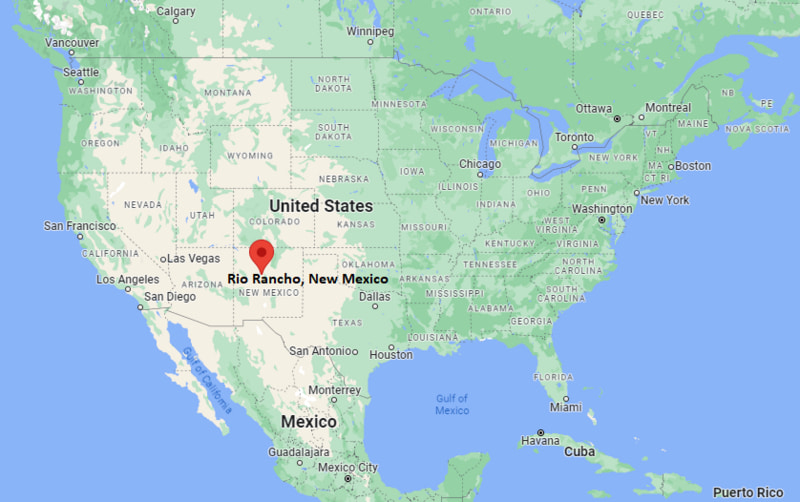
Rio Rancho Map, New Mexico, USA
Where is Rio Rancho?: The Google Map showing the location of Rio Rancho in the U.S. state of New Mexico.
Where is Rio Rancho Located?
Rio Rancho is a city located in the Bernalillo County and Sandoval County of New Mexico, United States. Rio Rancho lies between 40.3763701 Degrees North latitudes and 104.6921874 Degrees West longitudes. According to 2020 U.S.census, the population of Rio Rancho city is 104046 people and the city has a total area of 103.42 sq mi. The city has numerous parks and recreational facilities.
Most Viewed US Maps
| USA Sttae Map | USA Region Map | USA Road Map |
| USA County Map | Where is USA in World Map? | US ZIP Code Map |
| USA Time Zones Map | US State and Capitals Map | USA Physical Map |
Find 4,400+ U.S. Cities by State - Explore Their Locations and Get Detailed Information
Rio Rancho, New Mexico Quick Facts
| Attribute | Details |
|---|---|
| City | Rio Rancho |
| County | Sandoval County |
| State | New Mexico |
| State Capital | Santa Fe |
| US Region | West |
| Latitude | 35.2328° N |
| Longitude | 106.6630° W |
| Elevation | 5,679 ft (1,731 m) |
| Land Area | 103.36 sq mi |
| Water Area | 0.00 sq mi |
| Total Area | 103.36 sq mi |
| Population (2020 Census) | 104,046 |
| Population Density | 1,006 per sq mi |
| ZIP Codes | 87124, 87144 |
| Area Code | 505 |
| Time Zone Standard | Mountain Standard Time (MST), UTC−7 |
| Time Zone Daylight | Mountain Daylight Time (MDT), UTC−6 |
| Currency | United States Dollar (USD) |
| FIPS Code | 35-63460 |
| Congressional District | New Mexico's 1st Congressional District |
Transportation and Connectivity in Rio Rancho, New Mexico
| Transportation Type | Details |
|---|---|
| Airport Name | Albuquerque International Sunport |
| IATA Code | ABQ |
| Port | No major seaport; inland city location |
| Major Highways | U.S. Highway 550, New Mexico State Road 528, Paseo del Norte, Southern Boulevard |
| Train/Amtrak Service | New Mexico Rail Runner Express service available in nearby Albuquerque |
| Local Bus/Transit Service | Rio Metro Regional Transit District provides bus connections within the Albuquerque metropolitan area |
- U.S. Highway 550: Connects Rio Rancho with Albuquerque, Bernalillo, and communities north toward northwest New Mexico.
- New Mexico State Road 528: Provides a major north-south route through Rio Rancho and connects residential areas with nearby cities.
- Paseo del Norte: A major east-west roadway linking Rio Rancho with Albuquerque and regional transportation routes.
- Southern Boulevard: Provides local access across southern Rio Rancho and nearby commercial areas.
Top Places to Visit in Rio Rancho, New Mexico
| Landmark Name | Type |
|---|---|
| Rio Rancho Sports Complex | Sports and Recreation Facility |
| Santa Ana Star Center | Entertainment Arena |
| Corrales Bosque Preserve | Nature Preserve |
| Elena Gallegos Open Space | Natural Recreation Area |
| Petroglyph National Monument | Historic and Cultural Site |
| J&R Vintage Auto Museum | Automobile Museum |
| Cabezon Park | Community Park |
| A Park Above | Public Park |
| Albuquerque Balloon Fiesta Park | Event and Recreation Area |
| Rio Rancho Aquatic Center | Recreation Facility |
Driving Distances from Rio Rancho, New Mexico to Nearby Cities
| City | State | Distance (mi) | Approx. Drive Time |
|---|---|---|---|
| Albuquerque | New Mexico | 15 mi | 25 minutes |
| Bernalillo | New Mexico | 10 mi | 15 minutes |
| Corrales | New Mexico | 8 mi | 15 minutes |
| Los Lunas | New Mexico | 45 mi | 50 minutes |
| Santa Fe | New Mexico | 65 mi | 1 hour 10 minutes |
| Las Vegas | New Mexico | 130 mi | 2 hours |
| Gallup | New Mexico | 140 mi | 2 hours |
| Farmington | New Mexico | 180 mi | 3 hours |
| Flagstaff | Arizona | 320 mi | 5 hours |
| Denver | Colorado | 450 mi | 6 hours 30 minutes |
Colleges and Universities Near Rio Rancho, New Mexico
| Institution Name | Type | Level | Notable For |
|---|---|---|---|
| Central New Mexico Community College - Rio Rancho Campus | Public | Community College | Career training, nursing, technology, and workforce programs |
| University of New Mexico | Public | University | Research, medicine, engineering, and liberal arts |
| University of New Mexico West | Public | University Campus | Higher education programs and regional learning services |
| New Mexico Highlands University | Public | University | Education, business, and liberal arts programs |
| Sandoval Academy of Bilingual Education | Public | K–12 District | Bilingual primary and secondary education |
| Rio Rancho Public Schools | Public | K–12 District | Primary and secondary education |
Waterbodies Near Rio Rancho, New Mexico
Rio Grande River, Bosque del Rio Grande, Alameda Drain, Corrales Riverside waterways, and nearby irrigation channels of the Middle Rio Grande Valley.
Golf Courses Near Rio Rancho
Arroyo del Oso Golf Course, Santa Ana Golf Club, Ladera Golf Course, University of New Mexico Championship Golf Course, and Twin Warriors Golf Club.
Rio Rancho, New Mexico — Key Historical Facts
- Rio Rancho began in the 1960s when AMREP Corporation developed Rio Rancho Estates on former ranch land northwest of Albuquerque.
- The community grew from a planned retirement area into one of New Mexico's largest cities with expanding residential neighborhoods.
- Rio Rancho was officially incorporated as a city in 1981 after decades of population growth. :contentReference[oaicite:0]{index=0}
- The city became known for its connection to technology industries, including the development of major manufacturing facilities.
- Rio Rancho developed parks, trails, sports facilities, and community centers to support its growing population. :contentReference[oaicite:1]{index=1}
Stadiums and Sports Facilities Near Rio Rancho
| Facility Name | Type | Location |
|---|---|---|
| Rio Rancho Sports Complex | Multi-Sport Recreation Facility | Rio Rancho, New Mexico |
| Rio Rancho Events Center | Sports and Entertainment Arena | Rio Rancho, New Mexico |
| Rio Rancho High School Stadium | High School Sports Stadium | Rio Rancho, New Mexico |
| V. Sue Cleveland High School Sports Facilities | High School Sports Facility | Rio Rancho, New Mexico |
| University Stadium | College Football Stadium | Albuquerque, New Mexico |
References
- City of Rio Rancho Official Website
- Sandoval County Government
- U.S. Census Bureau
- New Mexico Tourism Department
- Petroglyph National Monument - National Park Service
New Mexico Maps & Info
- Where is Alamogordo
- Where is Artesia
- Where is Aztec
- Where is Belen
- Where is Bernalillo
- Where is Bloomfield
- Where is Bosque Farms
- Where is Carlsbad
- Where is Chaparral
- Where is Clovis
- Where is Corrales
- Where is Deming
- Where is Edgewood
- Where is El Cerro Mission
- Where is Eldorado at Santa Fe
- Where is Farmington
- Where is Gallup
- Where is Grants
- Where is Hobbs
- Where is Holloman AFB
- Where is Las Cruces
- Where is Los Alamos
- Where is Los Chaves
- Where is Los Lunas
- Where is Los Ranchos de Albuquerque
- Where is Lovington
- Where is Meadow Lake
- Where is North Hobbs
- Where is North Valley
- Where is Paradise Hills
- Where is Placitas
- Where is Portales
- Where is Raton
- Where is Rio Rancho
- Where is Roswell
- Where is Ruidoso
- Where is Santa Fe
- Where is Santa Teresa
- Where is Shiprock
- Where is Silver City
- Where is Socorro
- Where is South Valley
- Where is Sunland Park
- Where is Taos
- Where is Truth or Consequences
- Where is Tucumcari
- Where is White Rock
- Where is Zuni Pueblo