Written and Fact-checked by Whereig Editors, Reviewed by Mukesh Kumar| Updated On: May 15, 2026
Map of Sandoval County - Sandoval County is a county located in the U.S. state of New Mexico. Sandoval County Map showing cities, highways, important places and water bodies. Get Where is Sandoval County located in the map, major cities in Sandoval county, population, areas, and places of interest.
Map of Sandoval County, New Mexico
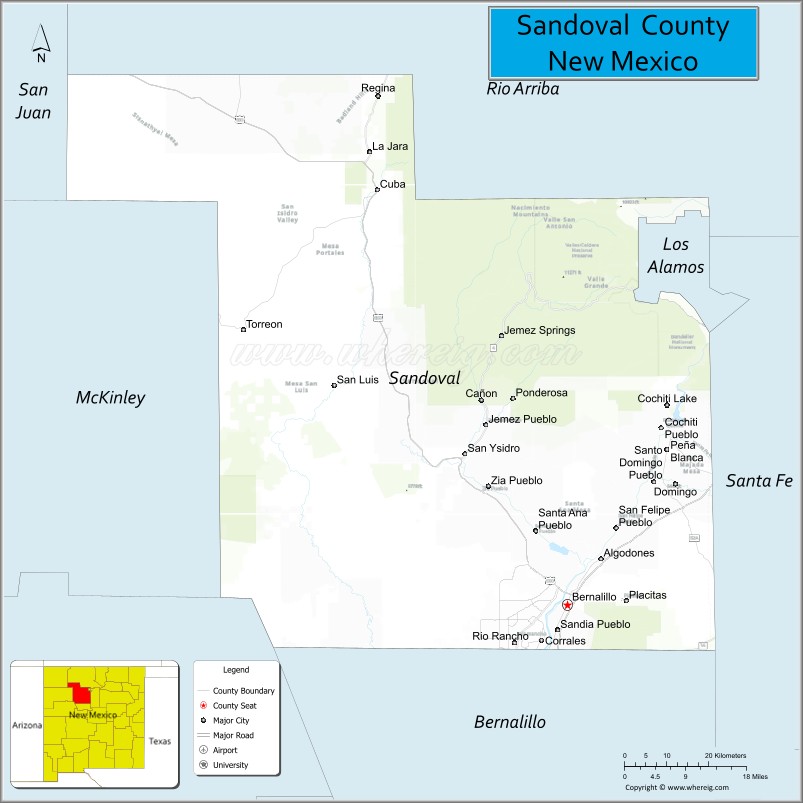
About Sandoval County Map, New Mexico: The map showing the county boundary, county seat, major cities, highways, water bodies and neighbouring counties.
Other New Mexico Maps & Info
About Sandoval County, New Mexico
Sandoval County is a county located in the U.S. state of New Mexico. It's county seat is Bernalillo. As per 2020 census, the population of Sandoval County is 151369 people and population density is square miles. According to the United States Census Bureau, the county has a total area of 3,710 sq mi (9,609 km2). Sandoval County was established on 1903.
Sandoval County Facts
| Continent | North America |
| Country | United States |
| State | New Mexico |
| County Seat | Bernalillo |
| Largest City/Town | Rio Rancho |
| Established | 1903 |
| Total Area | 3,714 sq mi (9,620 sq km) |
| Land Area | 3,711 sq mi (9,611 sq km) |
| Water Area | 3 sq mi (9 sq km) |
| Population | 148,834 (Census 2020) |
| Population Density | 40.1 people per sq mi |
| Time Zone | Mountain Time Zone |
| Major Highways | Interstate 25, U.S. Highway 550, State Road 528, State Road 4 |
| Major Rivers | Rio Grande, Jemez River |
| Neighboring Counties | Rio Arriba County, Los Alamos County, Santa Fe County, Bernalillo County, McKinley County, Cibola County, San Juan County |
| Famous For | Rio Rancho, Jemez Mountains, Native American pueblos, and volcanic landscapes |
| Top Attractions | Jemez Springs, Valles Caldera National Preserve, Petroglyph National Monument nearby, and Santa Ana Pueblo |
| Official Website | Official Website |
About Sandoval County, New Mexico
Sandoval County is located in north-central New Mexico and was established in 1903. The county seat is Bernalillo, while Rio Rancho is the largest city and one of the fastest-growing communities in the state. The county is known for volcanic landscapes, mountain recreation, Native American pueblos, and its mix of urban development and scenic wilderness areas.
Cities and Towns in Sandoval County, New Mexico
| City/Town | Population (Census 2020) | Latitude & Longitude |
|---|---|---|
| Rio Rancho | 104,046 | 35.2334°N, 106.6630°W |
| Bernalillo (county seat) | 10,660 | 35.3000°N, 106.5511°W |
| Corrales | 8,329 | 35.2378°N, 106.6067°W |
| Jemez Springs | 195 | 35.7795°N, 106.6886°W |
| Cuba | 740 | 36.0220°N, 106.9584°W |
| Placitas | 4,452 | 35.3061°N, 106.4242°W |
| Algodones | 866 | 35.3811°N, 106.4795°W |
| Pena Blanca | 388 | 35.5736°N, 106.3378°W |
| San Ysidro | 194 | 35.5620°N, 106.7739°W |
| Zia Pueblo | Native American community | 35.5042°N, 106.7261°W |
Golf Courses in Sandoval County, New Mexico
| Golf Course | Location | Latitude & Longitude |
|---|---|---|
| Santa Ana Golf Club | Bernalillo | 35.3297°N, 106.5761°W |
| Twin Warriors Golf Club | Santa Ana Pueblo | 35.3983°N, 106.5461°W |
| Rio Rancho Country Club | Rio Rancho | 35.2475°N, 106.6703°W |
| Chamisa Hills Country Club | Rio Rancho | 35.2658°N, 106.6747°W |
Roads and Highways in Sandoval County, New Mexico
Major highways connect the county to Albuquerque, mountain recreation areas, and northwestern New Mexico.
- Interstate 25 - major north-south interstate connecting Bernalillo with Albuquerque and Santa Fe
- U.S. Highway 550 - route linking Bernalillo with Cuba and northwestern New Mexico
- State Road 528 - major commuter corridor through Rio Rancho
- State Road 4 - scenic highway leading to Jemez Springs and Valles Caldera
Neighboring Counties of Sandoval County
- Rio Arriba County (north)
- Los Alamos County (northeast)
- Santa Fe County (east)
- Bernalillo County (south)
- Cibola County (west)
- McKinley County (west)
- San Juan County (northwest)
Top Attractions in Sandoval County, New Mexico
The county offers a mix of natural, cultural, and recreational attractions.
- Valles Caldera National Preserve - volcanic caldera featuring scenic meadows, wildlife, and hiking
- Jemez Springs - mountain village known for hot springs and forest scenery
- Santa Ana Pueblo - Native American pueblo with cultural attractions and resort facilities
- Petroglyph National Monument nearby - volcanic escarpment with ancient rock carvings
- Coronado Historic Site - archaeological site connected to early Spanish exploration
- Jemez Mountain Trail Scenic Byway - scenic route through forests, canyons, and volcanic areas
- Bandelier National Monument nearby - cliff dwellings and archaeological trails
- Rio Rancho Event Center - entertainment and sports venue
- Kasha-Katuwe Tent Rocks National Monument nearby - unique cone-shaped rock formations
- Santa Ana Star Casino Hotel - entertainment and gaming destination
- Fenton Lake State Park - fishing, camping, and mountain recreation area
- Placitas hiking trails - desert foothill recreation and scenic mountain views
Distance from Sandoval County to Nearby Cities
The following distances are measured by road (driving).
- Rio Rancho to Albuquerque (Bernalillo County), New Mexico - 18 mi (29 km)
- Bernalillo to Santa Fe (Santa Fe County), New Mexico - 52 mi (84 km)
- Rio Rancho to Los Alamos (Los Alamos County), New Mexico - 60 mi (97 km)
- Bernalillo to Española (Rio Arriba County), New Mexico - 58 mi (93 km)
- Rio Rancho to Gallup (McKinley County), New Mexico - 121 mi (195 km)
- Bernalillo to Farmington (San Juan County), New Mexico - 160 mi (257 km)
- Rio Rancho to Taos (Taos County), New Mexico - 135 mi (217 km)
- Bernalillo to Roswell (Chaves County), New Mexico - 215 mi (346 km)
- Rio Rancho to El Paso (El Paso County), Texas - 287 mi (462 km)
- Bernalillo to Phoenix (Maricopa County), Arizona - 414 mi (666 km)
- Rio Rancho to Denver (Denver County), Colorado - 451 mi (726 km)
- Bernalillo to Tucson (Pima County), Arizona - 490 mi (788 km)
FAQs about Sandoval County
Sandoval County is located in north-central New Mexico surrounding parts of the Albuquerque metropolitan area.
The population of Sandoval County was 148,834 according to the Census 2020.
Sandoval County is known for Rio Rancho, Native American pueblos, volcanic scenery, and mountain recreation.
The county is served by Interstate 25, U.S. Highway 550, State Road 528, and State Road 4.
Yes, Sandoval County has several golf facilities including Twin Warriors Golf Club and Santa Ana Golf Club.
References
- QuickFacts - U.S. Census Bureau
- United States Census Bureau
- United States Geological Survey (USGS)
- National Geodetic Survey
- Official County Website
- Bernalillo County Map
- Catron County Map
- Chaves County Map
- Cibola County Map
- Colfax County Map
- Curry County Map
- De Baca County Map
- Doña Ana County Map
- Eddy County Map
- Grant County Map
- Guadalupe County Map
- Harding County Map
- Hidalgo County Map
- Lea County Map
- Lincoln County Map
- Los Alamos County Map
- Luna County Map
- McKinley County Map
- Mora County Map
- Otero County Map
- Quay County Map
- Rio Arriba County Map
- Roosevelt County Map
- Sandoval County Map
- San Juan County Map
- San Miguel County Map
- Santa Fe County Map
- Sierra County Map
- Socorro County Map
- Taos County Map
- Torrance County Map
- Union County Map
- Valencia County Map
- Alabama Counties
- Alaska boroughs
- Arizona Counties
- Arkansas Counties
- California County Map
- Colorado Counties
- Connecticut Counties
- Delaware Counties
- Florida County Map
- Georgia County Map
- Hawaii Counties
- Idaho Counties
- Illinois Counties
- Indiana Counties
- Iowa Counties
- Kansas Counties
- Kentucky Counties
- Louisiana Counties
- Maine Counties
- Maryland Counties
- Massachusetts Counties
- Michigan County Map
- Minnesota Counties
- Mississippi Counties
- Missouri Counties
- Montana Counties
- Nebraska Counties
- Nevada Counties
- New York Counties
- New Hampshire Counties
- New Jersey Counties
- New Mexico Counties
- North Carolina Counties
- North Dakota Counties
- Ohio County Map
- Oklahoma Counties
- Oregon Counties
- Pennsylvania Counties
- Rhode Island Counties
- South Carolina Counties
- South Dakota Counties
- Map of Tennessee
- Texas County Map
- Utah Counties
- Vermont Counties
- Virginia Counties
- Washington Counties
- West Virginia Counties
- Wisconsin Counties
- Wyoming Counties