Written and Fact-checked by Whereig Editors, Reviewed by Mukesh Kumar| Updated On: May 15, 2026
Map of Valencia County - Valencia County is a county located in the U.S. state of New Mexico. Valencia County Map showing cities, highways, important places and water bodies. Get Where is Valencia County located in the map, major cities in Valencia county, population, areas, and places of interest.
Map of Valencia County, New Mexico
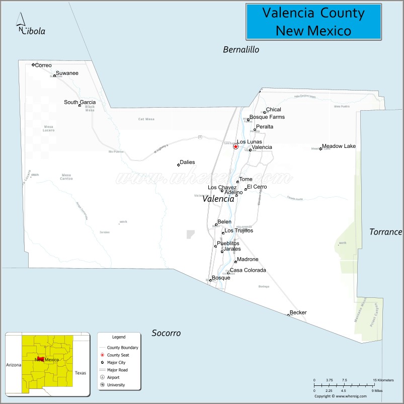
About Valencia County Map, New Mexico: The map showing the county boundary, county seat, major cities, highways, water bodies and neighbouring counties.
Other New Mexico Maps & Info
About Valencia County, New Mexico
Valencia County is a county located in the U.S. state of New Mexico. It's county seat is Los Lunas. As per 2020 census, the population of Valencia County is 77190 people and population density is square miles. According to the United States Census Bureau, the county has a total area of 1,068 sq mi (2,766 km2). Valencia County was established on 1852.
Valencia County Facts
| Continent | North America |
| Country | United States |
| State | New Mexico |
| County Seat | Los Lunas |
| Largest City/Town | Los Lunas |
| Established | 1852 |
| Total Area | 1,068 sq mi (2,766 sq km) |
| Land Area | 1,061 sq mi (2,748 sq km) |
| Water Area | 7 sq mi (18 sq km) |
| Population | 76,569 (Census 2020) |
| Population Density | 72.2 people per sq mi |
| Time Zone | Mountain Time Zone (MST/MDT) |
| Major Highways | Interstate 25, New Mexico State Road 6, New Mexico State Road 47, New Mexico State Road 314 |
| Major Rivers | Rio Grande |
| Neighboring Counties | Bernalillo County, Torrance County, Socorro County, Cibola County |
| Famous For | Rio Grande Valley, farming communities, Los Lunas Decalogue Stone, historic pueblos |
| Top Attractions | Tome Hill, Rio Grande Bosque, Los Lunas Museum of Heritage and Arts, El Cerro de Los Lunas |
| Official Website | Official Website |
About Valencia County, New Mexico
Valencia County is located in central New Mexico in the United States and was established in 1852. The county seat is Los Lunas, which is also the largest town. The county follows the Rio Grande Valley and includes agricultural lands, historic Hispanic communities, and growing suburban areas south of Albuquerque.
Cities and Towns in Valencia County, New Mexico
| City/Town | Population (Census 2020) | Latitude & Longitude |
|---|---|---|
| Los Lunas (county seat) | 17,242 | 34.8064°N, 106.7336°W |
| Belen | 7,360 | 34.6628°N, 106.7764°W |
| Bosque Farms | 3,917 | 34.8545°N, 106.6986°W |
| Peralta | 3,685 | 34.8376°N, 106.6886°W |
| Los Chavez (CDP) | 5,971 | 34.7273°N, 106.7609°W |
| Meadow Lake (CDP) | 4,200 | 34.8017°N, 106.5431°W |
| Valencia (CDP) | 2,092 | 34.7953°N, 106.7014°W |
| Jarales (CDP) | 1,476 | 34.6123°N, 106.7631°W |
| Pajarito Mesa (CDP) | 748 | 34.6650°N, 106.8889°W |
| Rio Communities | 4,875 | 34.6481°N, 106.7336°W |
| Tomé (CDP) | 1,867 | 34.7442°N, 106.7622°W |
| Veguita (CDP) | 232 | 34.4595°N, 106.8092°W |
Golf Courses in Valencia County, New Mexico
| Golf Course | Location | Latitude & Longitude |
|---|---|---|
| Tierra Del Sol Golf Club | Belen | 34.6464°N, 106.7575°W |
| Las Aves Golf Course | Bosque Farms | 34.8561°N, 106.6969°W |
Roads and Highways in Valencia County, New Mexico
Major highways connect Valencia County with Albuquerque and southern New Mexico communities.
- Interstate 25 - runs north-south through the county and links Los Lunas and Belen with Albuquerque and Socorro
- New Mexico State Road 6 - connects Los Lunas with Interstate 40 and western New Mexico
- New Mexico State Road 47 - follows the Rio Grande valley through rural farming communities
- New Mexico State Road 314 - serves older communities along the eastern side of the Rio Grande
- New Mexico State Road 304 - provides regional access between Belen and eastern parts of the county
Neighboring Counties of Valencia County
- Bernalillo County (north)
- Torrance County (east)
- Socorro County (south)
- Cibola County (west)
Top Attractions in Valencia County, New Mexico
The county offers a mix of natural and cultural attractions.
- Tome Hill - historic hilltop pilgrimage site with panoramic views of the Rio Grande Valley.
- Los Lunas Museum of Heritage and Arts - museum featuring local history, culture, and regional exhibits.
- El Cerro de Los Lunas - volcanic hill area associated with the famous Decalogue Stone.
- Rio Grande Bosque Trails - scenic walking and wildlife viewing areas along the river.
- Harvey House Museum - historic railroad museum located in Belen.
- Whitfield Wildlife Conservation Area - birdwatching and outdoor recreation area near Belen.
- Belen Rail Runner Station - transportation hub connecting the county with Albuquerque and Santa Fe.
- Our Lady of Belen Church - historic adobe church and local landmark.
- Valencia County Fairgrounds - community venue for rodeos, fairs, and regional events.
- Bosque Farms Rodeo Grounds - popular equestrian and rodeo facility in Bosque Farms.
Distance from Valencia County to Nearby Cities
The following distances are measured by road (driving).
- Los Lunas to Albuquerque (Bernalillo County), New Mexico - 26 mi (42 km)
- Los Lunas to Santa Fe (Santa Fe County), New Mexico - 82 mi (132 km)
- Los Lunas to Belen (Valencia County), New Mexico - 11 mi (18 km)
- Los Lunas to Socorro (Socorro County), New Mexico - 63 mi (101 km)
- Los Lunas to Rio Rancho (Sandoval County), New Mexico - 39 mi (63 km)
- Los Lunas to Moriarty (Torrance County), New Mexico - 49 mi (79 km)
- Los Lunas to Grants (Cibola County), New Mexico - 78 mi (126 km)
- Los Lunas to Las Cruces (Dona Ana County), New Mexico - 197 mi (317 km)
- Los Lunas to Truth or Consequences (Sierra County), New Mexico - 136 mi (219 km)
- Los Lunas to Espanola (Rio Arriba County), New Mexico - 112 mi (180 km)
- Los Lunas to Farmington (San Juan County), New Mexico - 208 mi (335 km)
- Los Lunas to Roswell (Chaves County), New Mexico - 204 mi (328 km)
FAQs about Valencia County
Valencia County is located in central New Mexico south of Albuquerque along the Rio Grande Valley.
Valencia County had a population of 76,569 according to the Census 2020.
Valencia County is known for farming communities, Rio Grande landscapes, Tome Hill, and the Los Lunas Decalogue Stone.
The major highways include Interstate 25, New Mexico State Road 6, and New Mexico State Road 47.
Yes, Valencia County has golf facilities including Tierra Del Sol Golf Club and Las Aves Golf Course.
References
- QuickFacts - U.S. Census Bureau
- United States Census Bureau
- United States Geological Survey (USGS)
- National Geodetic Survey
- Official County Website
- Bernalillo County Map
- Catron County Map
- Chaves County Map
- Cibola County Map
- Colfax County Map
- Curry County Map
- De Baca County Map
- Doña Ana County Map
- Eddy County Map
- Grant County Map
- Guadalupe County Map
- Harding County Map
- Hidalgo County Map
- Lea County Map
- Lincoln County Map
- Los Alamos County Map
- Luna County Map
- McKinley County Map
- Mora County Map
- Otero County Map
- Quay County Map
- Rio Arriba County Map
- Roosevelt County Map
- Sandoval County Map
- San Juan County Map
- San Miguel County Map
- Santa Fe County Map
- Sierra County Map
- Socorro County Map
- Taos County Map
- Torrance County Map
- Union County Map
- Valencia County Map
- Alabama Counties
- Alaska boroughs
- Arizona Counties
- Arkansas Counties
- California County Map
- Colorado Counties
- Connecticut Counties
- Delaware Counties
- Florida County Map
- Georgia County Map
- Hawaii Counties
- Idaho Counties
- Illinois Counties
- Indiana Counties
- Iowa Counties
- Kansas Counties
- Kentucky Counties
- Louisiana Counties
- Maine Counties
- Maryland Counties
- Massachusetts Counties
- Michigan County Map
- Minnesota Counties
- Mississippi Counties
- Missouri Counties
- Montana Counties
- Nebraska Counties
- Nevada Counties
- New York Counties
- New Hampshire Counties
- New Jersey Counties
- New Mexico Counties
- North Carolina Counties
- North Dakota Counties
- Ohio County Map
- Oklahoma Counties
- Oregon Counties
- Pennsylvania Counties
- Rhode Island Counties
- South Carolina Counties
- South Dakota Counties
- Map of Tennessee
- Texas County Map
- Utah Counties
- Vermont Counties
- Virginia Counties
- Washington Counties
- West Virginia Counties
- Wisconsin Counties
- Wyoming Counties