Written and Fact-checked by Whereig Editors, Reviewed by Mukesh Kumar| Updated On: May 15, 2026
Map of De Baca County - De Baca County is a county located in the U.S. state of New Mexico. De Baca County Map showing cities, highways, important places and water bodies. Get Where is De Baca County located in the map, major cities in De Baca county, population, areas, and places of interest.
Map of De Baca County, New Mexico
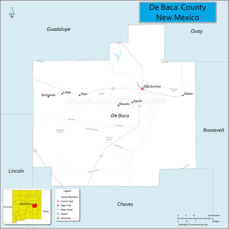
About De Baca County Map, New Mexico: The map showing the county boundary, county seat, major cities, highways, water bodies and neighbouring counties.
Other New Mexico Maps & Info
About De Baca County, New Mexico
De Baca County is a county located in the U.S. state of New Mexico. It's county seat is Fort Sumner. As per 2020 census, the population of De Baca County is 1680 people and population density is square miles. According to the United States Census Bureau, the county has a total area of 2,325 sq mi (6,022 km2). De Baca County was established on 1917.
De Baca County Facts
| Continent | North America |
| Country | United States |
| State | New Mexico |
| County Seat | Fort Sumner |
| Largest City/Town | Fort Sumner |
| Established | 1917 |
| Total Area | 2,334 sq mi (6,045 sq km) |
| Land Area | 2,323 sq mi (6,016 sq km) |
| Water Area | 11 sq mi (28 sq km) |
| Population | 1,698 (Census 2020) |
| Population Density | 0.7 people per sq mi |
| Time Zone | Mountain Time Zone |
| Major Highways | U.S. Highway 60, U.S. Highway 84, State Road 20 |
| Major Rivers | Pecos River |
| Neighboring Counties | Quay County, Guadalupe County, Roosevelt County, Curry County, Chaves County |
| Famous For | Billy the Kid history, Fort Sumner Historic Site, ranching, and Pecos River valley landscapes |
| Top Attractions | Bosque Redondo Memorial, Billy the Kid Museum, Sumner Lake State Park, and Fort Sumner Historic Site |
| Official Website | Official Website |
About De Baca County, New Mexico
De Baca County is located in eastern New Mexico and was established in 1917 after being separated from Guadalupe County. The county seat is Fort Sumner, which is also the largest community in the county. The county is known for ranching, wide-open plains, Pecos River scenery, and historic sites connected to Billy the Kid and Native American history.
Cities and Towns in De Baca County, New Mexico
| City/Town | Population (Census 2020) | Latitude & Longitude |
|---|---|---|
| Fort Sumner (county seat) | 915 | 34.4717°N, 104.2455°W |
| Yeso (CDP) | 28 | 34.4042°N, 104.4978°W |
| Taiban (CDP) | 59 | 34.3597°N, 103.8817°W |
| Lake Sumner (CDP) | 143 | 34.6169°N, 104.3878°W |
| Fort Sumner South (CDP) | Small rural community | 34.4439°N, 104.2533°W |
Golf Courses in De Baca County, New Mexico
| Golf Course | Location | Latitude & Longitude |
|---|---|---|
| Fort Sumner Municipal Golf Course | Fort Sumner | 34.4694°N, 104.2508°W |
| Sumner Lake Recreation Golf Area | Lake Sumner | 34.6178°N, 104.3892°W |
Roads and Highways in De Baca County, New Mexico
Major highways connect the county to nearby regions and cities.
- U.S. Highway 60 - east-west route connecting Fort Sumner with Clovis and Vaughn
- U.S. Highway 84 - major regional highway linking Fort Sumner with Santa Rosa and Roswell
- State Road 20 - local highway serving rural ranching communities and recreation areas
Neighboring Counties of De Baca County
- Quay County (north)
- Guadalupe County (west)
- Chaves County (southwest)
- Roosevelt County (south)
- Curry County (east)
Top Attractions in De Baca County, New Mexico
The county offers a mix of natural and cultural attractions.
- Bosque Redondo Memorial - historic site commemorating the forced relocation of Navajo and Mescalero Apache people
- Billy the Kid Museum - museum dedicated to the life and history of the famous outlaw
- Fort Sumner Historic Site - preserved frontier military post and regional history landmark
- Sumner Lake State Park - recreation area popular for boating, fishing, and camping
- Pecos River Recreation Areas - scenic fishing and wildlife viewing spots along the river corridor
- Fort Sumner Cemetery - burial site associated with Billy the Kid history
- De Baca County Courthouse - historic county landmark in Fort Sumner
- Fort Sumner Rail District - historic railroad area tied to regional transportation history
- Eastern New Mexico Prairie Scenic Drives - open countryside routes with ranching landscapes
- Lake Sumner Wildlife Areas - birdwatching and outdoor recreation destinations
Distance from De Baca County to Nearby Cities
The following distances are measured by road (driving).
- Fort Sumner to Roswell (Chaves County), New Mexico - 58 mi (93 km)
- Fort Sumner to Clovis (Curry County), New Mexico - 82 mi (132 km)
- Fort Sumner to Santa Rosa (Guadalupe County), New Mexico - 59 mi (95 km)
- Fort Sumner to Albuquerque (Bernalillo County), New Mexico - 184 mi (296 km)
- Fort Sumner to Tucumcari (Quay County), New Mexico - 96 mi (154 km)
- Fort Sumner to Portales (Roosevelt County), New Mexico - 71 mi (114 km)
- Fort Sumner to Amarillo (Potter County), Texas - 170 mi (274 km)
- Fort Sumner to Lubbock (Lubbock County), Texas - 172 mi (277 km)
- Fort Sumner to Santa Fe (Santa Fe County), New Mexico - 188 mi (303 km)
- Fort Sumner to Las Cruces (Dona Ana County), New Mexico - 251 mi (404 km)
- Fort Sumner to El Paso (El Paso County), Texas - 292 mi (470 km)
- Fort Sumner to Midland (Midland County), Texas - 262 mi (422 km)
FAQs about De Baca County
De Baca County is located in eastern New Mexico along the Pecos River valley.
The population of De Baca County was 1,698 according to the Census 2020.
De Baca County is known for Billy the Kid history, ranching, Fort Sumner, and Bosque Redondo Memorial.
The county is served by U.S. Highway 60, U.S. Highway 84, and State Road 20.
Yes, De Baca County has small golf facilities including Fort Sumner Municipal Golf Course.
References
- QuickFacts - U.S. Census Bureau
- United States Census Bureau
- United States Geological Survey (USGS)
- National Geodetic Survey
- Official County Website
- Bernalillo County Map
- Catron County Map
- Chaves County Map
- Cibola County Map
- Colfax County Map
- Curry County Map
- De Baca County Map
- Doña Ana County Map
- Eddy County Map
- Grant County Map
- Guadalupe County Map
- Harding County Map
- Hidalgo County Map
- Lea County Map
- Lincoln County Map
- Los Alamos County Map
- Luna County Map
- McKinley County Map
- Mora County Map
- Otero County Map
- Quay County Map
- Rio Arriba County Map
- Roosevelt County Map
- Sandoval County Map
- San Juan County Map
- San Miguel County Map
- Santa Fe County Map
- Sierra County Map
- Socorro County Map
- Taos County Map
- Torrance County Map
- Union County Map
- Valencia County Map
- Alabama Counties
- Alaska boroughs
- Arizona Counties
- Arkansas Counties
- California County Map
- Colorado Counties
- Connecticut Counties
- Delaware Counties
- Florida County Map
- Georgia County Map
- Hawaii Counties
- Idaho Counties
- Illinois Counties
- Indiana Counties
- Iowa Counties
- Kansas Counties
- Kentucky Counties
- Louisiana Counties
- Maine Counties
- Maryland Counties
- Massachusetts Counties
- Michigan County Map
- Minnesota Counties
- Mississippi Counties
- Missouri Counties
- Montana Counties
- Nebraska Counties
- Nevada Counties
- New York Counties
- New Hampshire Counties
- New Jersey Counties
- New Mexico Counties
- North Carolina Counties
- North Dakota Counties
- Ohio County Map
- Oklahoma Counties
- Oregon Counties
- Pennsylvania Counties
- Rhode Island Counties
- South Carolina Counties
- South Dakota Counties
- Map of Tennessee
- Texas County Map
- Utah Counties
- Vermont Counties
- Virginia Counties
- Washington Counties
- West Virginia Counties
- Wisconsin Counties
- Wyoming Counties