Written and Fact-checked by Whereig Editors, Reviewed by Mukesh Kumar| Updated On: May 15, 2026
Map of Mora County - Mora County is a county located in the U.S. state of New Mexico. Mora County Map showing cities, highways, important places and water bodies. Get Where is Mora County located in the map, major cities in Mora county, population, areas, and places of interest.
Map of Mora County, New Mexico
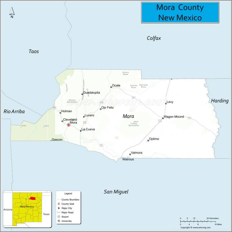
About Mora County Map, New Mexico: The map showing the county boundary, county seat, major cities, highways, water bodies and neighbouring counties.
Other New Mexico Maps & Info
About Mora County, New Mexico
Mora County is a county located in the U.S. state of New Mexico. It's county seat is Mora. As per 2020 census, the population of Mora County is 4196 people and population density is square miles. According to the United States Census Bureau, the county has a total area of 1,931 sq mi (5,001 km2). Mora County was established on 1860.
Mora County Facts
| Continent | North America |
| Country | United States |
| State | New Mexico |
| County Seat | Mora |
| Largest City/Town | Mora |
| Established | 1860 |
| Total Area | 1,934 sq mi (5,009 sq km) |
| Land Area | 1,930 sq mi (4,999 sq km) |
| Water Area | 4 sq mi (10 sq km) |
| Population | 4,189 (Census 2020) |
| Population Density | 2.2 people per sq mi |
| Time Zone | Mountain Time Zone |
| Major Highways | State Road 3, State Road 518, State Road 94 |
| Major Rivers | Mora River, Canadian River tributaries |
| Neighboring Counties | Colfax County, Harding County, San Miguel County, Taos County, Rio Arriba County |
| Famous For | Mountain valleys, Hispanic heritage villages, ranching, and scenic forests |
| Top Attractions | St. Vrain Mill, Cleveland Roller Mill Museum, Coyote Creek State Park, and Mora Valley |
| Official Website | Official Website |
About Mora County, New Mexico
Mora County is located in north-central New Mexico and was established in 1860 during the territorial era. The county seat and largest community is Mora, a historic settlement surrounded by mountain valleys and forests. The county is known for its strong Hispanic cultural heritage, ranching traditions, scenic landscapes, and quiet rural communities in the Sangre de Cristo foothills.
Cities and Towns in Mora County, New Mexico
| City/Town | Population (Census 2020) | Latitude & Longitude |
|---|---|---|
| Mora (county seat) | 517 | 35.9745°N, 105.3308°W |
| Wagon Mound | 250 | 36.0081°N, 104.7089°W |
| Cleveland | 245 | 35.9936°N, 105.4470°W |
| Chacon (CDP) | 53 | 36.1508°N, 105.3920°W |
| Golondrinas (CDP) | 52 | 35.9384°N, 105.1058°W |
| Guadalupita (CDP) | 330 | 36.1317°N, 105.2178°W |
| Holman (CDP) | 180 | 36.0400°N, 105.3806°W |
| Watrous (historic community) | Historic settlement | 35.7928°N, 105.0186°W |
| Ledoux (historic village) | Historic community | 36.1164°N, 105.4197°W |
Golf Courses in Mora County, New Mexico
| Golf Course | Location | Latitude & Longitude |
|---|---|---|
| Mora Valley Recreation Golf Area | Mora | 35.9758°N, 105.3294°W |
| Cleveland Community Golf Grounds | Cleveland | 35.9920°N, 105.4481°W |
Roads and Highways in Mora County, New Mexico
Major highways connect the county to mountain communities and nearby regions.
- State Road 3 - scenic highway linking Mora with Ribera and Interstate 25
- State Road 518 - major route connecting Mora with Taos and Las Vegas
- State Road 94 - rural highway serving ranching and agricultural communities
Neighboring Counties of Mora County
- Colfax County (north)
- Harding County (east)
- San Miguel County (south)
- Taos County (west)
- Rio Arriba County (northwest)
Top Attractions in Mora County, New Mexico
The county offers a mix of natural, historical, and cultural attractions.
- St. Vrain Mill - historic 19th-century flour mill and cultural landmark in Mora
- Cleveland Roller Mill Museum - restored mill museum showcasing local agricultural history
- Coyote Creek State Park - forested recreation area with camping, fishing, and hiking
- Mora Valley - scenic valley known for ranches, mountain landscapes, and traditional villages
- Watrous Historic Area - historic settlement linked to the Santa Fe Trail
- Guadalupita Canyon Scenic Drives - mountain routes with forest and meadow scenery
- Holman Hill Recreation Areas - hiking and outdoor recreation destinations
- Historic Hispanic Villages - traditional adobe communities with cultural heritage
- Canadian River Tributary Valleys - fishing and nature observation areas
- Ledoux Cultural Sites - rural mountain landscapes and historical communities
- Wagon Mound Historic District - historic railroad and ranching community
- Sangre de Cristo Mountain Views - scenic overlooks and photography locations
Distance from Mora County to Nearby Cities
The following distances are measured by road (driving).
- Mora to Las Vegas (San Miguel County), New Mexico - 37 mi (60 km)
- Mora to Taos (Taos County), New Mexico - 72 mi (116 km)
- Mora to Raton (Colfax County), New Mexico - 89 mi (143 km)
- Mora to Santa Fe (Santa Fe County), New Mexico - 77 mi (124 km)
- Mora to Albuquerque (Bernalillo County), New Mexico - 139 mi (224 km)
- Mora to Española (Rio Arriba County), New Mexico - 83 mi (134 km)
- Mora to Pueblo (Pueblo County), Colorado - 194 mi (312 km)
- Mora to Colorado Springs (El Paso County), Colorado - 229 mi (369 km)
- Mora to Amarillo (Potter County), Texas - 264 mi (425 km)
- Mora to Denver (Denver County), Colorado - 311 mi (501 km)
- Mora to Roswell (Chaves County), New Mexico - 181 mi (291 km)
- Mora to El Paso (El Paso County), Texas - 358 mi (576 km)
FAQs about Mora County
Mora County is located in north-central New Mexico within the Sangre de Cristo mountain region.
The population of Mora County was 4,189 according to the Census 2020.
Mora County is known for mountain valleys, Hispanic heritage villages, ranching, and scenic forests.
The county is primarily served by State Roads 3, 518, and 94.
Mora County has small recreation golf facilities near Mora and Cleveland.
References
- QuickFacts - U.S. Census Bureau
- United States Census Bureau
- United States Geological Survey (USGS)
- National Geodetic Survey
- Official County Website
- Bernalillo County Map
- Catron County Map
- Chaves County Map
- Cibola County Map
- Colfax County Map
- Curry County Map
- De Baca County Map
- Doña Ana County Map
- Eddy County Map
- Grant County Map
- Guadalupe County Map
- Harding County Map
- Hidalgo County Map
- Lea County Map
- Lincoln County Map
- Los Alamos County Map
- Luna County Map
- McKinley County Map
- Mora County Map
- Otero County Map
- Quay County Map
- Rio Arriba County Map
- Roosevelt County Map
- Sandoval County Map
- San Juan County Map
- San Miguel County Map
- Santa Fe County Map
- Sierra County Map
- Socorro County Map
- Taos County Map
- Torrance County Map
- Union County Map
- Valencia County Map
- Alabama Counties
- Alaska boroughs
- Arizona Counties
- Arkansas Counties
- California County Map
- Colorado Counties
- Connecticut Counties
- Delaware Counties
- Florida County Map
- Georgia County Map
- Hawaii Counties
- Idaho Counties
- Illinois Counties
- Indiana Counties
- Iowa Counties
- Kansas Counties
- Kentucky Counties
- Louisiana Counties
- Maine Counties
- Maryland Counties
- Massachusetts Counties
- Michigan County Map
- Minnesota Counties
- Mississippi Counties
- Missouri Counties
- Montana Counties
- Nebraska Counties
- Nevada Counties
- New York Counties
- New Hampshire Counties
- New Jersey Counties
- New Mexico Counties
- North Carolina Counties
- North Dakota Counties
- Ohio County Map
- Oklahoma Counties
- Oregon Counties
- Pennsylvania Counties
- Rhode Island Counties
- South Carolina Counties
- South Dakota Counties
- Map of Tennessee
- Texas County Map
- Utah Counties
- Vermont Counties
- Virginia Counties
- Washington Counties
- West Virginia Counties
- Wisconsin Counties
- Wyoming Counties