Written and Fact-checked by Whereig Editors, Reviewed by Mukesh Kumar| Updated On: May 15, 2026
Map of Socorro County - Socorro County is a county located in the U.S. state of New Mexico. Socorro County Map showing cities, highways, important places and water bodies. Get Where is Socorro County located in the map, major cities in Socorro county, population, areas, and places of interest.
Map of Socorro County, New Mexico
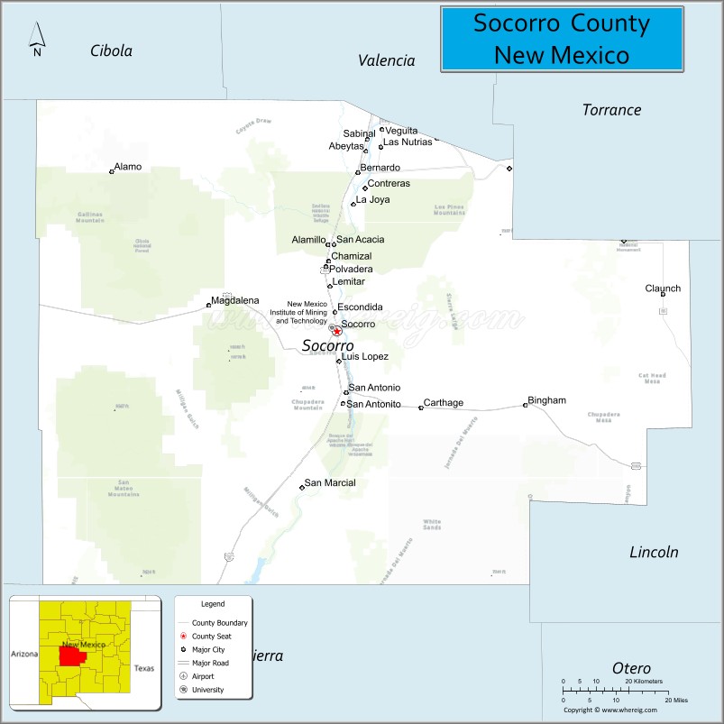
About Socorro County Map, New Mexico: The map showing the county boundary, county seat, major cities, highways, water bodies and neighbouring counties.
Other New Mexico Maps & Info
About Socorro County, New Mexico
Socorro County is a county located in the U.S. state of New Mexico. It's county seat is Socorro. As per 2020 census, the population of Socorro County is 16311 people and population density is square miles. According to the United States Census Bureau, the county has a total area of 6,647 sq mi (17,216 km2). Socorro County was established on 1852.
Socorro County Facts
| Continent | North America |
| Country | United States |
| State | New Mexico |
| County Seat | Socorro |
| Largest City/Town | Socorro |
| Established | 1852 |
| Total Area | 6,649 sq mi (17,221 sq km) |
| Land Area | 6,647 sq mi (17,215 sq km) |
| Water Area | 2 sq mi (5 sq km) |
| Population | 16,595 (Census 2020) |
| Population Density | 2.5 people per sq mi |
| Time Zone | Mountain Time Zone (MST/MDT) |
| Major Highways | Interstate 25, U.S. Route 60, U.S. Route 380, New Mexico State Road 1 |
| Major Rivers | Rio Grande |
| Neighboring Counties | Bernalillo County, Valencia County, Torrance County, Lincoln County, Sierra County, Catron County, Cibola County |
| Famous For | Very Large Array, Bosque del Apache National Wildlife Refuge, mining history, desert landscapes |
| Top Attractions | Very Large Array, Bosque del Apache National Wildlife Refuge, Sevilleta National Wildlife Refuge, San Lorenzo Canyon |
| Official Website | Official Website |
About Socorro County, New Mexico
Socorro County is located in the central part of New Mexico in the United States and was established in 1852. The county seat is Socorro, which is also the largest city. The county is known for its wide desert valleys, mountain ranges, scientific research sites, and wildlife refuges along the Rio Grande.
Cities and Towns in Socorro County, New Mexico
| City/Town | Population (Census 2020) | Latitude & Longitude |
|---|---|---|
| Socorro (county seat) | 8,403 | 34.0584°N, 106.8914°W |
| Magdalena | 806 | 34.1167°N, 107.2439°W |
| Lemitar | 330 | 34.1612°N, 106.9178°W |
| Polvadera | 438 | 34.3626°N, 106.8956°W |
| Escondida (CDP) | 146 | 34.1198°N, 106.8925°W |
| La Joya (CDP) | 611 | 34.3470°N, 106.8531°W |
| San Acacia (CDP) | 51 | 34.2556°N, 106.8908°W |
| San Antonio (CDP) | 56 | 33.9170°N, 106.8650°W |
| Veguita (CDP) | 232 | 34.4595°N, 106.8092°W |
| Luis Lopez (CDP) | 74 | 34.0717°N, 106.8853°W |
Golf Courses in Socorro County, New Mexico
| Golf Course | Location | Latitude & Longitude |
|---|---|---|
| Socorro Springs Golf Course | Socorro | 34.0425°N, 106.9015°W |
Roads and Highways in Socorro County, New Mexico
Major highways connect the county to nearby regions and cities.
- Interstate 25 - runs north-south through Socorro and connects the county with Albuquerque and Las Cruces
- U.S. Route 60 - crosses the county east-west and links Socorro with Magdalena and Catron County
- U.S. Route 380 - connects eastern parts of the county with Carrizozo and southeastern New Mexico
- New Mexico State Road 1 - follows older routes along the Rio Grande valley communities
- New Mexico State Road 107 - connects Socorro with western rural areas and scientific facilities
Neighboring Counties of Socorro County
- Cibola County (northwest)
- Bernalillo County (north)
- Valencia County (north)
- Torrance County (east)
- Lincoln County (east)
- Sierra County (south)
- Catron County (west)
Top Attractions in Socorro County, New Mexico
The county offers a mix of natural and cultural attractions.
- Very Large Array - world-famous radio astronomy observatory with giant satellite dishes west of Socorro.
- Bosque del Apache National Wildlife Refuge - major birdwatching area known for sandhill cranes and migrating geese.
- Sevilleta National Wildlife Refuge - large protected desert and grassland habitat along the Rio Grande.
- San Lorenzo Canyon - scenic canyon with sandstone cliffs, hiking trails, and desert views.
- New Mexico Tech Mineral Museum - museum featuring minerals, rocks, and mining exhibits in Socorro.
- Socorro Plaza - historic downtown square with shops, restaurants, and local events.
- Fort Craig Historic Site - preserved Civil War-era military post near San Antonio.
- Elephant Butte Lake State Park - nearby recreation area popular for boating and fishing.
- Quebradas Backcountry Byway - scenic driving route through rugged volcanic landscapes.
- Magdalena Historic District - small historic western town with old railroad and ranching heritage.
Distance from Socorro County to Nearby Cities
The following distances are measured by road (driving).
- Socorro to Albuquerque (Bernalillo County), New Mexico - 75 mi (121 km)
- Socorro to Las Cruces (Dona Ana County), New Mexico - 147 mi (237 km)
- Socorro to Truth or Consequences (Sierra County), New Mexico - 75 mi (121 km)
- Socorro to Magdalena (Socorro County), New Mexico - 26 mi (42 km)
- Socorro to Belen (Valencia County), New Mexico - 50 mi (80 km)
- Socorro to Los Lunas (Valencia County), New Mexico - 63 mi (101 km)
- Socorro to Santa Fe (Santa Fe County), New Mexico - 146 mi (235 km)
- Socorro to Carrizozo (Lincoln County), New Mexico - 109 mi (175 km)
- Socorro to Grants (Cibola County), New Mexico - 97 mi (156 km)
- Socorro to Silver City (Grant County), New Mexico - 173 mi (278 km)
- Socorro to Roswell (Chaves County), New Mexico - 201 mi (323 km)
- Socorro to Deming (Luna County), New Mexico - 157 mi (253 km)
FAQs about Socorro County
Socorro County is located in central New Mexico along the Rio Grande Valley.
Socorro County had a population of 16,595 according to the Census 2020.
Socorro County is known for the Very Large Array, wildlife refuges, astronomy research, and desert scenery.
The main highways in the county include Interstate 25, U.S. Route 60, and U.S. Route 380.
Yes, Socorro Springs Golf Course is a public golf facility located in Socorro.
References
- QuickFacts - U.S. Census Bureau
- United States Census Bureau
- United States Geological Survey (USGS)
- National Geodetic Survey
- Official County Website
- Bernalillo County Map
- Catron County Map
- Chaves County Map
- Cibola County Map
- Colfax County Map
- Curry County Map
- De Baca County Map
- Doña Ana County Map
- Eddy County Map
- Grant County Map
- Guadalupe County Map
- Harding County Map
- Hidalgo County Map
- Lea County Map
- Lincoln County Map
- Los Alamos County Map
- Luna County Map
- McKinley County Map
- Mora County Map
- Otero County Map
- Quay County Map
- Rio Arriba County Map
- Roosevelt County Map
- Sandoval County Map
- San Juan County Map
- San Miguel County Map
- Santa Fe County Map
- Sierra County Map
- Socorro County Map
- Taos County Map
- Torrance County Map
- Union County Map
- Valencia County Map
- Alabama Counties
- Alaska boroughs
- Arizona Counties
- Arkansas Counties
- California County Map
- Colorado Counties
- Connecticut Counties
- Delaware Counties
- Florida County Map
- Georgia County Map
- Hawaii Counties
- Idaho Counties
- Illinois Counties
- Indiana Counties
- Iowa Counties
- Kansas Counties
- Kentucky Counties
- Louisiana Counties
- Maine Counties
- Maryland Counties
- Massachusetts Counties
- Michigan County Map
- Minnesota Counties
- Mississippi Counties
- Missouri Counties
- Montana Counties
- Nebraska Counties
- Nevada Counties
- New York Counties
- New Hampshire Counties
- New Jersey Counties
- New Mexico Counties
- North Carolina Counties
- North Dakota Counties
- Ohio County Map
- Oklahoma Counties
- Oregon Counties
- Pennsylvania Counties
- Rhode Island Counties
- South Carolina Counties
- South Dakota Counties
- Map of Tennessee
- Texas County Map
- Utah Counties
- Vermont Counties
- Virginia Counties
- Washington Counties
- West Virginia Counties
- Wisconsin Counties
- Wyoming Counties