Written and Fact-checked by Whereig Editors, Reviewed by Mukesh Kumar| Updated On: May 15, 2026
Map of Rio Arriba County - Rio Arriba County is a county located in the U.S. state of New Mexico. Rio Arriba County Map showing cities, highways, important places and water bodies. Get Where is Rio Arriba County located in the map, major cities in Rio Arriba county, population, areas, and places of interest.
Map of Rio Arriba County, New Mexico
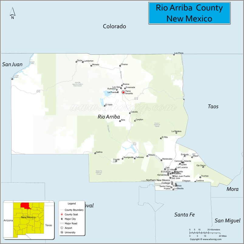
About Rio Arriba County Map, New Mexico: The map showing the county boundary, county seat, major cities, highways, water bodies and neighbouring counties.
Other New Mexico Maps & Info
About Rio Arriba County, New Mexico
Rio Arriba County is a county located in the U.S. state of New Mexico. It's county seat is Tierra Amarilla. As per 2020 census, the population of Rio Arriba County is 40179 people and population density is square miles. According to the United States Census Bureau, the county has a total area of 5,858 sq mi (15,172 km2). Rio Arriba County was established on 1852.
Rio Arriba County Facts
| Continent | North America |
| Country | United States |
| State | New Mexico |
| County Seat | Tierra Amarilla |
| Largest City/Town | Española (partly) |
| Established | 1852 |
| Total Area | 5,896 sq mi (15,271 sq km) |
| Land Area | 5,861 sq mi (15,180 sq km) |
| Water Area | 35 sq mi (91 sq km) |
| Population | 40,246 (Census 2020) |
| Population Density | 6.9 people per sq mi |
| Time Zone | Mountain Time Zone |
| Major Highways | U.S. Highway 64, U.S. Highway 84, U.S. Highway 285, State Road 68 |
| Major Rivers | Rio Grande, Chama River, Rio Brazos |
| Neighboring Counties | Taos County, Mora County, Santa Fe County, Los Alamos County, Sandoval County, San Juan County, Conejos County (Colorado), Archuleta County (Colorado) |
| Famous For | Rio Grande landscapes, Hispanic heritage, Georgia O’Keeffe country, and mountain recreation |
| Top Attractions | Ghost Ranch, Chama Scenic Railroad, Abiquiú, and Heron Lake State Park |
| Official Website | Official Website |
About Rio Arriba County, New Mexico
Rio Arriba County is located in north-central New Mexico and was established in 1852 during the territorial era. The county seat is Tierra Amarilla, while Española is the largest population center partly located within the county. The county is known for dramatic river valleys, mountain forests, traditional Hispanic villages, Native American culture, and world-famous artistic landscapes.
Cities and Towns in Rio Arriba County, New Mexico
| City/Town | Population (Census 2020) | Latitude & Longitude |
|---|---|---|
| Española (partly) | 10,495 | 35.9911°N, 106.0806°W |
| Tierra Amarilla (county seat) | 383 | 36.7017°N, 106.5492°W |
| Chama | 1,054 | 36.9031°N, 106.5795°W |
| Abiquiú | 231 | 36.2078°N, 106.3189°W |
| Dixon | 1,489 | 36.1992°N, 105.8942°W |
| Ojo Caliente | 573 | 36.3017°N, 106.0486°W |
| Canjilon | 237 | 36.4795°N, 106.4398°W |
| El Rito | 712 | 36.3439°N, 106.1920°W |
| Hernandez | 946 | 36.0539°N, 106.1206°W |
| Velarde | 500 | 36.1803°N, 105.9753°W |
Golf Courses in Rio Arriba County, New Mexico
| Golf Course | Location | Latitude & Longitude |
|---|---|---|
| Tierra del Sol Golf Club | Española | 35.9845°N, 106.0839°W |
| Chama Valley Recreation Golf Area | Chama | 36.9042°N, 106.5775°W |
| Ojo Caliente Resort Golf Grounds | Ojo Caliente area | 36.3028°N, 106.0475°W |
Roads and Highways in Rio Arriba County, New Mexico
Major highways connect the county to mountain communities, river valleys, and northern New Mexico regions.
- U.S. Highway 64 - scenic highway crossing northern New Mexico mountain and canyon landscapes
- U.S. Highway 84 - major north-south route linking Española, Chama, and Colorado
- U.S. Highway 285 - regional corridor connecting Española with Santa Fe and southern Colorado
- State Road 68 - scenic route following the Rio Grande valley between Española and Taos
Neighboring Counties of Rio Arriba County
- Taos County (east)
- Mora County (southeast)
- Santa Fe County (south)
- Los Alamos County (southwest)
- Sandoval County (west)
- San Juan County (west)
- Conejos County, Colorado (north)
- Archuleta County, Colorado (northwest)
Top Attractions in Rio Arriba County, New Mexico
The county offers a mix of natural, artistic, and cultural attractions.
- Ghost Ranch - famous landscape retreat associated with artist Georgia O’Keeffe
- Cumbres and Toltec Scenic Railroad - historic narrow-gauge steam railroad operating from Chama
- Abiquiú - artistic village known for adobe architecture and desert landscapes
- Heron Lake State Park - recreation area popular for boating, fishing, and camping
- El Vado Lake State Park - scenic reservoir surrounded by mountain forests
- Ojo Caliente Mineral Springs Resort - historic hot springs destination
- Rio Grande Gorge scenic areas - dramatic canyon views and hiking opportunities
- Monastery of Christ in the Desert - remote Benedictine monastery in a canyon setting
- Chama Valley - mountain recreation and scenic train routes
- Plaza Blanca - striking white rock formations featured in Georgia O’Keeffe paintings
- Northern New Mexico vineyards and orchards - agricultural tourism in the Española Valley
- Traditional Hispanic villages - historic adobe communities with cultural heritage
Distance from Rio Arriba County to Nearby Cities
The following distances are measured by road (driving).
- Española to Santa Fe (Santa Fe County), New Mexico - 25 mi (40 km)
- Española to Taos (Taos County), New Mexico - 53 mi (85 km)
- Española to Los Alamos (Los Alamos County), New Mexico - 20 mi (32 km)
- Española to Albuquerque (Bernalillo County), New Mexico - 88 mi (142 km)
- Española to Farmington (San Juan County), New Mexico - 162 mi (261 km)
- Española to Chama (Rio Arriba County), New Mexico - 93 mi (150 km)
- Española to Durango (La Plata County), Colorado - 171 mi (275 km)
- Española to Pueblo (Pueblo County), Colorado - 218 mi (351 km)
- Española to Denver (Denver County), Colorado - 336 mi (541 km)
- Española to Gallup (McKinley County), New Mexico - 201 mi (323 km)
- Española to Roswell (Chaves County), New Mexico - 220 mi (354 km)
- Española to El Paso (El Paso County), Texas - 326 mi (525 km)
FAQs about Rio Arriba County
Rio Arriba County is located in north-central New Mexico near the Colorado border.
The population of Rio Arriba County was 40,246 according to the Census 2020.
Rio Arriba County is known for scenic river valleys, artistic landscapes, Hispanic heritage, and mountain recreation.
The county is served by U.S. Highway 64, U.S. Highway 84, U.S. Highway 285, and State Road 68.
Yes, Rio Arriba County has golf facilities including Tierra del Sol Golf Club in Española.
References
- QuickFacts - U.S. Census Bureau
- United States Census Bureau
- United States Geological Survey (USGS)
- National Geodetic Survey
- Official County Website
- Bernalillo County Map
- Catron County Map
- Chaves County Map
- Cibola County Map
- Colfax County Map
- Curry County Map
- De Baca County Map
- Doña Ana County Map
- Eddy County Map
- Grant County Map
- Guadalupe County Map
- Harding County Map
- Hidalgo County Map
- Lea County Map
- Lincoln County Map
- Los Alamos County Map
- Luna County Map
- McKinley County Map
- Mora County Map
- Otero County Map
- Quay County Map
- Rio Arriba County Map
- Roosevelt County Map
- Sandoval County Map
- San Juan County Map
- San Miguel County Map
- Santa Fe County Map
- Sierra County Map
- Socorro County Map
- Taos County Map
- Torrance County Map
- Union County Map
- Valencia County Map
- Alabama Counties
- Alaska boroughs
- Arizona Counties
- Arkansas Counties
- California County Map
- Colorado Counties
- Connecticut Counties
- Delaware Counties
- Florida County Map
- Georgia County Map
- Hawaii Counties
- Idaho Counties
- Illinois Counties
- Indiana Counties
- Iowa Counties
- Kansas Counties
- Kentucky Counties
- Louisiana Counties
- Maine Counties
- Maryland Counties
- Massachusetts Counties
- Michigan County Map
- Minnesota Counties
- Mississippi Counties
- Missouri Counties
- Montana Counties
- Nebraska Counties
- Nevada Counties
- New York Counties
- New Hampshire Counties
- New Jersey Counties
- New Mexico Counties
- North Carolina Counties
- North Dakota Counties
- Ohio County Map
- Oklahoma Counties
- Oregon Counties
- Pennsylvania Counties
- Rhode Island Counties
- South Carolina Counties
- South Dakota Counties
- Map of Tennessee
- Texas County Map
- Utah Counties
- Vermont Counties
- Virginia Counties
- Washington Counties
- West Virginia Counties
- Wisconsin Counties
- Wyoming Counties