Written and Fact-checked by Whereig Editors, Reviewed by Mukesh Kumar| Updated On: May 15, 2026
Map of Bernalillo County - Bernalillo County is a county located in the U.S. state of New Mexico. Bernalillo County Map showing cities, highways, important places and water bodies. Get Where is Bernalillo County located in the map, major cities in Bernalillo county, population, areas, and places of interest.
Map of Bernalillo County, New Mexico
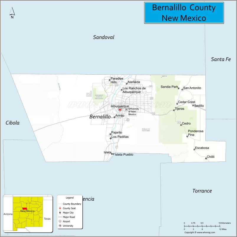
About Bernalillo County Map, New Mexico: The map showing the county boundary, county seat, major cities, highways, water bodies and neighbouring counties.
Other New Mexico Maps & Info
About Bernalillo County, New Mexico
Bernalillo County is a county located in the U.S. state of New Mexico. It's county seat is Albuquerque. As per 2020 census, the population of Bernalillo County is 674393 people and population density is square miles. According to the United States Census Bureau, the county has a total area of 1,166 sq mi (3,020 km2). Bernalillo County was established on 1852.
Bernalillo County Facts
| Continent | North America |
| Country | United States |
| State | New Mexico |
| County Seat | Albuquerque |
| Largest City/Town | Albuquerque |
| Established | 1852 |
| Total Area | 1,167 sq mi (3,023 sq km) |
| Land Area | 1,161 sq mi (3,007 sq km) |
| Water Area | 6 sq mi (16 sq km) |
| Population | 676,444 (Census 2020) |
| Population Density | 582.6 people per sq mi |
| Time Zone | Mountain Time Zone |
| Major Highways | Interstate 25, Interstate 40, U.S. Highway 66, State Road 45, State Road 47, Paseo del Norte |
| Major Rivers | Rio Grande |
| Neighboring Counties | Sandoval County, Santa Fe County, Torrance County, Valencia County, Cibola County |
| Famous For | Albuquerque International Balloon Fiesta, Sandia Mountains, Route 66 history, and Southwestern culture |
| Top Attractions | Old Town Albuquerque, Sandia Peak Tramway, Petroglyph National Monument, ABQ BioPark, and Balloon Fiesta Park |
| Official Website | Official Website |
About Bernalillo County, New Mexico
Bernalillo County is located in central New Mexico and was established in 1852 during the territorial period. The county seat is Albuquerque, which is also the largest city in New Mexico and the economic center of the state. The county is known for its desert scenery, the Rio Grande valley, mountain landscapes, Native American heritage, and major cultural festivals.
Cities and Towns in Bernalillo County, New Mexico
| City/Town | Population (Census 2020) | Latitude & Longitude |
|---|---|---|
| Albuquerque (county seat) | 564,559 | 35.0844°N, 106.6504°W |
| Los Ranchos de Albuquerque | 6,024 | 35.1617°N, 106.6428°W |
| Tijeras | 541 | 35.0806°N, 106.3878°W |
| Cedar Crest (CDP) | 958 | 35.1070°N, 106.3728°W |
| South Valley (CDP) | 41,452 | 35.0100°N, 106.6847°W |
| North Valley (CDP) | 13,223 | 35.1731°N, 106.6414°W |
| Pajarito Mesa (CDP) | 726 | 34.9798°N, 106.7831°W |
| Sandia Heights (CDP) | 3,193 | 35.1648°N, 106.4997°W |
| Carnuel (CDP) | 1,019 | 35.0606°N, 106.4578°W |
| Paradise Hills (CDP) | 4,349 | 35.1970°N, 106.7014°W |
| Isleta Village Proper (CDP) | 491 | 34.9078°N, 106.6886°W |
Golf Courses in Bernalillo County, New Mexico
| Golf Course | Location | Latitude & Longitude |
|---|---|---|
| UNM Championship Golf Course | Albuquerque | 35.1244°N, 106.5261°W |
| Sandia Golf Club | Albuquerque | 35.1898°N, 106.5975°W |
| Isleta Eagle Golf Club | Albuquerque | 34.9095°N, 106.6942°W |
| Ladera Golf Course | Albuquerque | 35.0964°N, 106.7447°W |
| Arroyo del Oso Golf Course | Albuquerque | 35.1331°N, 106.5661°W |
| Puerto del Sol Golf Course | Albuquerque | 35.0440°N, 106.6090°W |
| Paradise Hills Golf Club | Albuquerque | 35.1952°N, 106.6948°W |
| Paako Ridge Golf Club | Sandia Park | 35.1575°N, 106.3134°W |
Roads and Highways in Bernalillo County, New Mexico
Major highways connect the county to nearby regions and cities.
- Interstate 25 - north-south interstate connecting Albuquerque with Santa Fe and Las Cruces
- Interstate 40 - major east-west route linking Albuquerque with Arizona and Texas
- Historic U.S. Route 66 - famous highway running through central Albuquerque
- State Road 45 - connects western Albuquerque communities and suburban areas
- State Road 47 - route serving the Rio Grande valley south of Albuquerque
- Paseo del Norte - major urban corridor across northern Albuquerque
Neighboring Counties of Bernalillo County
- Sandoval County (northwest)
- Santa Fe County (northeast)
- Torrance County (east)
- Valencia County (south)
- Cibola County (west)
Top Attractions in Bernalillo County, New Mexico
The county offers a mix of natural and cultural attractions.
- Old Town Albuquerque - historic district with adobe buildings, shops, and museums
- Sandia Peak Tramway - scenic aerial tramway offering mountain and city views
- Petroglyph National Monument - protected volcanic landscape with ancient rock carvings
- ABQ BioPark - attraction complex featuring a zoo, aquarium, botanical garden, and Tingley Beach
- Balloon Fiesta Park - host site for the annual Albuquerque International Balloon Fiesta
- Indian Pueblo Cultural Center - museum and cultural center dedicated to Pueblo heritage
- Explora Science Center - interactive science museum for families and children
- New Mexico Museum of Natural History and Science - museum featuring dinosaurs and regional history
- Sandia Mountains - outdoor recreation area popular for hiking, skiing, and scenic drives
- Route 66 Neon District - historic stretch with classic signs, restaurants, and theaters
- Rio Grande Nature Center State Park - wildlife and birdwatching area along the Rio Grande
- Kimo Theatre - historic Pueblo Deco theater in downtown Albuquerque
- Isleta Resort and Casino - entertainment destination with gaming, concerts, and golf
- Coronado Historic Site - archaeological and cultural site connected to early Spanish exploration
Distance from Bernalillo County to Nearby Cities
The following distances are measured by road (driving).
- Albuquerque to Santa Fe (Santa Fe County), New Mexico - 64 mi (103 km)
- Albuquerque to Rio Rancho (Sandoval County), New Mexico - 18 mi (29 km)
- Albuquerque to Los Lunas (Valencia County), New Mexico - 27 mi (43 km)
- Albuquerque to Belen (Valencia County), New Mexico - 37 mi (60 km)
- Albuquerque to Las Vegas (San Miguel County), New Mexico - 122 mi (196 km)
- Albuquerque to Socorro (Socorro County), New Mexico - 75 mi (121 km)
- Albuquerque to Gallup (McKinley County), New Mexico - 139 mi (224 km)
- Albuquerque to Roswell (Chaves County), New Mexico - 205 mi (330 km)
- Albuquerque to Farmington (San Juan County), New Mexico - 182 mi (293 km)
- Albuquerque to Las Cruces (Dona Ana County), New Mexico - 225 mi (362 km)
- Albuquerque to Amarillo (Potter County), Texas - 288 mi (463 km)
- Albuquerque to Flagstaff (Coconino County), Arizona - 324 mi (521 km)
- Albuquerque to Denver (Denver County), Colorado - 448 mi (721 km)
- Albuquerque to El Paso (El Paso County), Texas - 267 mi (430 km)
FAQs about Bernalillo County
Bernalillo County is located in central New Mexico and includes the city of Albuquerque.
The population of Bernalillo County was 676,444 according to the Census 2020.
Bernalillo County is known for the Albuquerque International Balloon Fiesta, Route 66 history, and the Sandia Mountains.
The county is served by Interstate 25, Interstate 40, Historic Route 66, and several major state roads.
Yes, Bernalillo County has several golf courses including Sandia Golf Club, UNM Championship Golf Course, and Isleta Eagle Golf Club.
References
- QuickFacts - U.S. Census Bureau
- United States Census Bureau
- United States Geological Survey (USGS)
- National Geodetic Survey
- Official County Website
- Bernalillo County Map
- Catron County Map
- Chaves County Map
- Cibola County Map
- Colfax County Map
- Curry County Map
- De Baca County Map
- Doña Ana County Map
- Eddy County Map
- Grant County Map
- Guadalupe County Map
- Harding County Map
- Hidalgo County Map
- Lea County Map
- Lincoln County Map
- Los Alamos County Map
- Luna County Map
- McKinley County Map
- Mora County Map
- Otero County Map
- Quay County Map
- Rio Arriba County Map
- Roosevelt County Map
- Sandoval County Map
- San Juan County Map
- San Miguel County Map
- Santa Fe County Map
- Sierra County Map
- Socorro County Map
- Taos County Map
- Torrance County Map
- Union County Map
- Valencia County Map
- Alabama Counties
- Alaska boroughs
- Arizona Counties
- Arkansas Counties
- California County Map
- Colorado Counties
- Connecticut Counties
- Delaware Counties
- Florida County Map
- Georgia County Map
- Hawaii Counties
- Idaho Counties
- Illinois Counties
- Indiana Counties
- Iowa Counties
- Kansas Counties
- Kentucky Counties
- Louisiana Counties
- Maine Counties
- Maryland Counties
- Massachusetts Counties
- Michigan County Map
- Minnesota Counties
- Mississippi Counties
- Missouri Counties
- Montana Counties
- Nebraska Counties
- Nevada Counties
- New York Counties
- New Hampshire Counties
- New Jersey Counties
- New Mexico Counties
- North Carolina Counties
- North Dakota Counties
- Ohio County Map
- Oklahoma Counties
- Oregon Counties
- Pennsylvania Counties
- Rhode Island Counties
- South Carolina Counties
- South Dakota Counties
- Map of Tennessee
- Texas County Map
- Utah Counties
- Vermont Counties
- Virginia Counties
- Washington Counties
- West Virginia Counties
- Wisconsin Counties
- Wyoming Counties