Written and Fact-checked by Whereig Editors, Reviewed by Mukesh Kumar| Updated On: May 15, 2026
Map of Harding County - Harding County is a county located in the U.S. state of New Mexico. Harding County Map showing cities, highways, important places and water bodies. Get Where is Harding County located in the map, major cities in Harding county, population, areas, and places of interest.
Map of Harding County, New Mexico
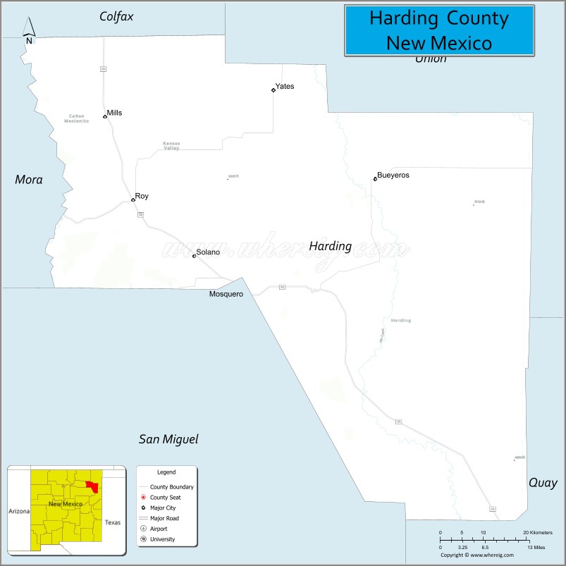
About Harding County Map, New Mexico: The map showing the county boundary, county seat, major cities, highways, water bodies and neighbouring counties.
Other New Mexico Maps & Info
About Harding County, New Mexico
Harding County is a county located in the U.S. state of New Mexico. It's county seat is Mosquero. As per 2020 census, the population of Harding County is 639 people and population density is square miles. According to the United States Census Bureau, the county has a total area of 2,126 sq mi (5,506 km2). Harding County was established on 1921.
Harding County Facts
| Continent | North America |
| Country | United States |
| State | New Mexico |
| County Seat | Mosquero |
| Largest City/Town | Roy |
| Established | 1921 |
| Total Area | 2,126 sq mi (5,505 sq km) |
| Land Area | 2,125 sq mi (5,504 sq km) |
| Water Area | 1 sq mi (1 sq km) |
| Population | 657 (Census 2020) |
| Population Density | 0.3 people per sq mi |
| Time Zone | Mountain Time Zone |
| Major Highways | State Road 39, State Road 120, State Road 402 |
| Major Rivers | Canadian River tributaries and seasonal prairie streams |
| Neighboring Counties | Union County, Colfax County, Mora County, San Miguel County, Quay County |
| Famous For | Open prairie ranchlands, cattle ranching, scenic mesas, and rural High Plains landscapes |
| Top Attractions | Kiowa National Grassland, Mills Canyon, Canadian River Valley, and historic Mosquero |
| Official Website | Official Website |
About Harding County, New Mexico
Harding County is located in northeastern New Mexico and was established in 1921. The county seat is Mosquero, while Roy is the largest community in the county. Harding County is one of the least populated counties in New Mexico and is known for ranching, rolling prairie landscapes, mesas, and remote scenic beauty across the High Plains region.
Cities and Towns in Harding County, New Mexico
| City/Town | Population (Census 2020) | Latitude & Longitude |
|---|---|---|
| Roy | 234 | 35.9439°N, 104.1911°W |
| Mosquero (county seat) | 93 | 35.7767°N, 103.9567°W |
| Solano (village) | 13 | 35.7995°N, 104.1711°W |
| Trementina (CDP) | 17 | 35.4669°N, 104.4945°W |
| Ragland (historic community) | Historic settlement | 35.8934°N, 103.4708°W |
Golf Courses in Harding County, New Mexico
| Golf Course | Location | Latitude & Longitude |
|---|---|---|
| Roy Community Golf Area | Roy | 35.9450°N, 104.1890°W |
| Mosquero Recreation Golf Grounds | Mosquero | 35.7762°N, 103.9589°W |
Roads and Highways in Harding County, New Mexico
Major highways connect the county to nearby regions and communities.
- State Road 39 - north-south route connecting Roy and Mosquero with nearby ranching regions
- State Road 120 - scenic highway linking Harding County with Mora and Colfax counties
- State Road 402 - rural route serving eastern prairie communities and ranchlands
Neighboring Counties of Harding County
- Union County (east)
- Colfax County (north)
- Mora County (west)
- San Miguel County (southwest)
- Quay County (south)
Top Attractions in Harding County, New Mexico
The county offers a mix of natural and historical attractions.
- Kiowa National Grassland - expansive grassland area with prairie scenery and wildlife viewing
- Mills Canyon - scenic canyon along the Canadian River with hiking and photography opportunities
- Canadian River Valley - remote landscape known for ranching and open plains scenery
- Historic Mosquero - small rural county seat with preserved western architecture
- Roy Community Museum - local museum focused on ranching and pioneer history
- Trementina Mesa Scenic Drives - countryside routes featuring mesas and prairie landscapes
- Prairie Wildlife Areas - birdwatching and wildlife viewing across grassland habitats
- Historic Ranchlands of Harding County - cattle ranching regions with Old West heritage
- Solano Historic Community - small historic settlement reflecting rural New Mexico history
- Night Sky Viewing Areas - remote locations known for dark skies and stargazing
Distance from Harding County to Nearby Cities
The following distances are measured by road (driving).
- Mosquero to Tucumcari (Quay County), New Mexico - 63 mi (101 km)
- Mosquero to Raton (Colfax County), New Mexico - 97 mi (156 km)
- Mosquero to Las Vegas (San Miguel County), New Mexico - 94 mi (151 km)
- Mosquero to Clayton (Union County), New Mexico - 70 mi (113 km)
- Mosquero to Santa Fe (Santa Fe County), New Mexico - 179 mi (288 km)
- Mosquero to Albuquerque (Bernalillo County), New Mexico - 205 mi (330 km)
- Mosquero to Amarillo (Potter County), Texas - 156 mi (251 km)
- Mosquero to Pueblo (Pueblo County), Colorado - 211 mi (340 km)
- Mosquero to Colorado Springs (El Paso County), Colorado - 247 mi (398 km)
- Mosquero to Oklahoma City (Oklahoma County), Oklahoma - 333 mi (536 km)
- Mosquero to Lubbock (Lubbock County), Texas - 240 mi (386 km)
- Mosquero to Denver (Denver County), Colorado - 330 mi (531 km)
FAQs about Harding County
Harding County is located in northeastern New Mexico within the High Plains region.
The population of Harding County was 657 according to the Census 2020.
Harding County is known for ranching, prairie landscapes, scenic canyons, and rural High Plains scenery.
The county is served primarily by New Mexico State Roads 39, 120, and 402.
Harding County has small community golf and recreation areas near Roy and Mosquero.
References
- QuickFacts - U.S. Census Bureau
- United States Census Bureau
- United States Geological Survey (USGS)
- National Geodetic Survey
- Official County Website
- Bernalillo County Map
- Catron County Map
- Chaves County Map
- Cibola County Map
- Colfax County Map
- Curry County Map
- De Baca County Map
- Doña Ana County Map
- Eddy County Map
- Grant County Map
- Guadalupe County Map
- Harding County Map
- Hidalgo County Map
- Lea County Map
- Lincoln County Map
- Los Alamos County Map
- Luna County Map
- McKinley County Map
- Mora County Map
- Otero County Map
- Quay County Map
- Rio Arriba County Map
- Roosevelt County Map
- Sandoval County Map
- San Juan County Map
- San Miguel County Map
- Santa Fe County Map
- Sierra County Map
- Socorro County Map
- Taos County Map
- Torrance County Map
- Union County Map
- Valencia County Map
- Alabama Counties
- Alaska boroughs
- Arizona Counties
- Arkansas Counties
- California County Map
- Colorado Counties
- Connecticut Counties
- Delaware Counties
- Florida County Map
- Georgia County Map
- Hawaii Counties
- Idaho Counties
- Illinois Counties
- Indiana Counties
- Iowa Counties
- Kansas Counties
- Kentucky Counties
- Louisiana Counties
- Maine Counties
- Maryland Counties
- Massachusetts Counties
- Michigan County Map
- Minnesota Counties
- Mississippi Counties
- Missouri Counties
- Montana Counties
- Nebraska Counties
- Nevada Counties
- New York Counties
- New Hampshire Counties
- New Jersey Counties
- New Mexico Counties
- North Carolina Counties
- North Dakota Counties
- Ohio County Map
- Oklahoma Counties
- Oregon Counties
- Pennsylvania Counties
- Rhode Island Counties
- South Carolina Counties
- South Dakota Counties
- Map of Tennessee
- Texas County Map
- Utah Counties
- Vermont Counties
- Virginia Counties
- Washington Counties
- West Virginia Counties
- Wisconsin Counties
- Wyoming Counties