Written and Fact-checked by Whereig Editors, Reviewed by Mukesh Kumar| Updated On: May 15, 2026
Map of Luna County - Luna County is a county located in the U.S. state of New Mexico. Luna County Map showing cities, highways, important places and water bodies. Get Where is Luna County located in the map, major cities in Luna county, population, areas, and places of interest.
Map of Luna County, New Mexico
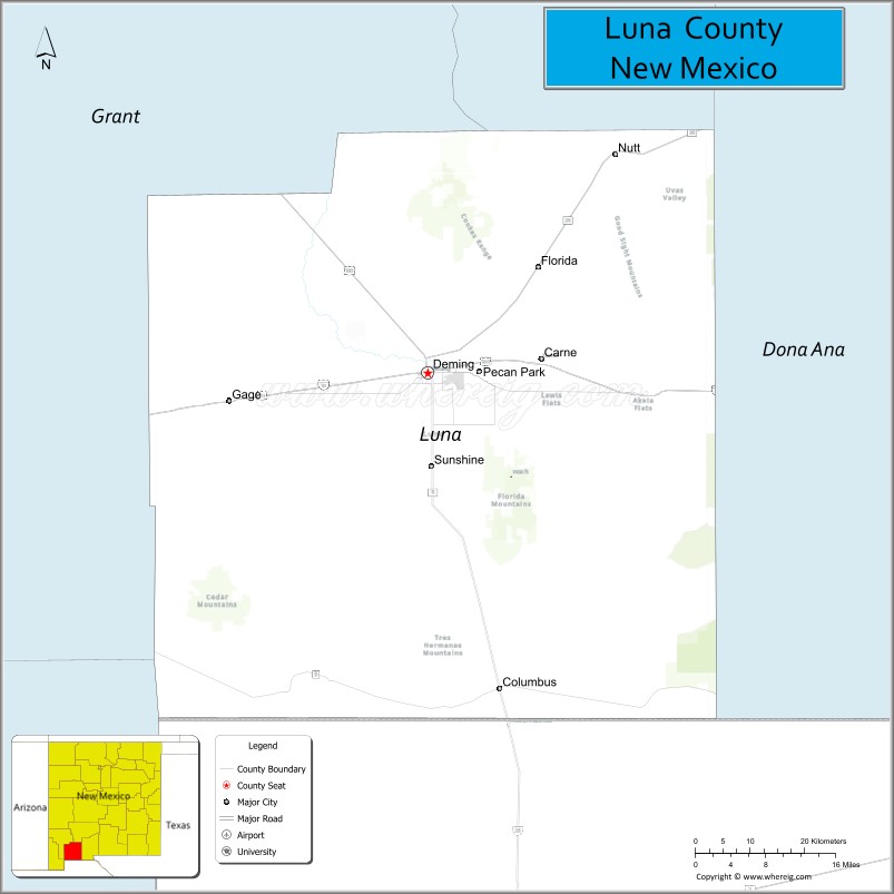
About Luna County Map, New Mexico: The map showing the county boundary, county seat, major cities, highways, water bodies and neighbouring counties.
Other New Mexico Maps & Info
About Luna County, New Mexico
Luna County is a county located in the U.S. state of New Mexico. It's county seat is Deming. As per 2020 census, the population of Luna County is 25532 people and population density is square miles. According to the United States Census Bureau, the county has a total area of 2,965 sq mi (7,679 km2). Luna County was established on 1901.
Luna County Facts
| Continent | North America |
| Country | United States |
| State | New Mexico |
| County Seat | Deming |
| Largest City/Town | Deming |
| Established | 1901 |
| Total Area | 2,965 sq mi (7,679 sq km) |
| Land Area | 2,965 sq mi (7,679 sq km) |
| Water Area | 0.5 sq mi (1.3 sq km) |
| Population | 25,427 (Census 2020) |
| Population Density | 8.6 people per sq mi |
| Time Zone | Mountain Time Zone |
| Major Highways | Interstate 10, U.S. Highway 180, State Road 11, State Road 26 |
| Major Rivers | Mimbres River (seasonal) |
| Neighboring Counties | Grant County, Sierra County, Dona Ana County, Hidalgo County |
| Famous For | Rockhounding, desert landscapes, agriculture, and Deming's historic railroad heritage |
| Top Attractions | Rockhound State Park, Deming Luna Mimbres Museum, City of Rocks State Park nearby, and Pancho Villa State Park |
| Official Website | Official Website |
About Luna County, New Mexico
Luna County is located in southwestern New Mexico and was established in 1901. The county seat and largest city is Deming, an important transportation and agricultural center along Interstate 10. The county is known for desert scenery, rock collecting, farming, and historic connections to railroads and the Old West.
Cities and Towns in Luna County, New Mexico
| City/Town | Population (Census 2020) | Latitude & Longitude |
|---|---|---|
| Deming (county seat) | 14,757 | 32.2687°N, 107.7586°W |
| Columbus | 1,442 | 31.8270°N, 107.6400°W |
| Sunshine (CDP) | 1,216 | 32.3548°N, 107.7589°W |
| Akela (CDP) | Small community | 32.4508°N, 108.0870°W |
| Nutt (historic settlement) | Historic community | 32.5958°N, 107.4406°W |
| Florida (CDP) | Historic rural area | 32.0786°N, 107.6183°W |
Golf Courses in Luna County, New Mexico
| Golf Course | Location | Latitude & Longitude |
|---|---|---|
| Rio Mimbres Country Club | Deming | 32.2550°N, 107.7706°W |
| Deming Municipal Golf Course | Deming | 32.2642°N, 107.7781°W |
Roads and Highways in Luna County, New Mexico
Major highways connect the county to nearby regions and border communities.
- Interstate 10 - major east-west interstate connecting Deming with Arizona, Las Cruces, and Texas
- U.S. Highway 180 - highway linking Deming with Silver City and southeastern Arizona
- State Road 11 - route connecting Deming with Columbus and the Mexico border
- State Road 26 - scenic road linking Deming with Hatch and central New Mexico
Neighboring Counties of Luna County
- Grant County (northwest)
- Sierra County (north)
- Dona Ana County (east)
- Hidalgo County (west and south)
Top Attractions in Luna County, New Mexico
The county offers a mix of natural, historical, and recreational attractions.
- Rockhound State Park - popular destination for hiking and gemstone collecting
- Deming Luna Mimbres Museum - museum featuring Native American pottery and regional history
- Pancho Villa State Park - historic site near Columbus connected to the 1916 border raid
- City of Rocks State Park nearby - unique volcanic rock formations and camping area
- Columbus Historic District - preserved border town with historic buildings and museums
- Mimbres Valley Scenic Drives - desert and mountain scenery through farming communities
- Rio Mimbres Country Club - recreation and golf destination in Deming
- Percha Dam and Desert Wildlife Areas - birdwatching and nature observation spots
- Deming Railroad Depot Museum - exhibits on railroad and transportation history
- Florida Mountains Wilderness Study Area - hiking and wildlife viewing destination
- Luna County Courthouse Historic Area - architectural landmark in downtown Deming
- Southwestern New Mexico Vineyards - wineries and agricultural tourism experiences
Distance from Luna County to Nearby Cities
The following distances are measured by road (driving).
- Deming to Las Cruces (Dona Ana County), New Mexico - 61 mi (98 km)
- Deming to Silver City (Grant County), New Mexico - 58 mi (93 km)
- Deming to Lordsburg (Hidalgo County), New Mexico - 60 mi (97 km)
- Deming to El Paso (El Paso County), Texas - 102 mi (164 km)
- Deming to Albuquerque (Bernalillo County), New Mexico - 238 mi (383 km)
- Deming to Tucson (Pima County), Arizona - 221 mi (356 km)
- Deming to Phoenix (Maricopa County), Arizona - 289 mi (465 km)
- Deming to Alamogordo (Otero County), New Mexico - 114 mi (183 km)
- Deming to Roswell (Chaves County), New Mexico - 214 mi (344 km)
- Deming to Santa Fe (Santa Fe County), New Mexico - 300 mi (483 km)
- Deming to Juarez, Chihuahua, Mexico - 123 mi (198 km)
- Deming to Flagstaff (Coconino County), Arizona - 432 mi (695 km)
FAQs about Luna County
Luna County is located in southwestern New Mexico near the Arizona and Mexico borders.
The population of Luna County was 25,427 according to the Census 2020.
Luna County is known for desert landscapes, rock collecting, agriculture, and historic border communities.
The county is served by Interstate 10, U.S. Highway 180, State Road 11, and State Road 26.
Yes, Luna County has golf facilities including Rio Mimbres Country Club and Deming Municipal Golf Course.
References
- QuickFacts - U.S. Census Bureau
- United States Census Bureau
- United States Geological Survey (USGS)
- National Geodetic Survey
- Official County Website
- Bernalillo County Map
- Catron County Map
- Chaves County Map
- Cibola County Map
- Colfax County Map
- Curry County Map
- De Baca County Map
- Doña Ana County Map
- Eddy County Map
- Grant County Map
- Guadalupe County Map
- Harding County Map
- Hidalgo County Map
- Lea County Map
- Lincoln County Map
- Los Alamos County Map
- Luna County Map
- McKinley County Map
- Mora County Map
- Otero County Map
- Quay County Map
- Rio Arriba County Map
- Roosevelt County Map
- Sandoval County Map
- San Juan County Map
- San Miguel County Map
- Santa Fe County Map
- Sierra County Map
- Socorro County Map
- Taos County Map
- Torrance County Map
- Union County Map
- Valencia County Map
- Alabama Counties
- Alaska boroughs
- Arizona Counties
- Arkansas Counties
- California County Map
- Colorado Counties
- Connecticut Counties
- Delaware Counties
- Florida County Map
- Georgia County Map
- Hawaii Counties
- Idaho Counties
- Illinois Counties
- Indiana Counties
- Iowa Counties
- Kansas Counties
- Kentucky Counties
- Louisiana Counties
- Maine Counties
- Maryland Counties
- Massachusetts Counties
- Michigan County Map
- Minnesota Counties
- Mississippi Counties
- Missouri Counties
- Montana Counties
- Nebraska Counties
- Nevada Counties
- New York Counties
- New Hampshire Counties
- New Jersey Counties
- New Mexico Counties
- North Carolina Counties
- North Dakota Counties
- Ohio County Map
- Oklahoma Counties
- Oregon Counties
- Pennsylvania Counties
- Rhode Island Counties
- South Carolina Counties
- South Dakota Counties
- Map of Tennessee
- Texas County Map
- Utah Counties
- Vermont Counties
- Virginia Counties
- Washington Counties
- West Virginia Counties
- Wisconsin Counties
- Wyoming Counties