Written and Fact-checked by Whereig Editors, Reviewed by Mukesh Kumar| Updated On: May 15, 2026
Map of Lea County - Lea County is a county located in the U.S. state of New Mexico. Lea County Map showing cities, highways, important places and water bodies. Get Where is Lea County located in the map, major cities in Lea county, population, areas, and places of interest.
Map of Lea County, New Mexico
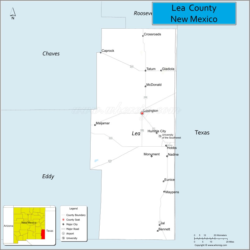
About Lea County Map, New Mexico: The map showing the county boundary, county seat, major cities, highways, water bodies and neighbouring counties.
Other New Mexico Maps & Info
About Lea County, New Mexico
Lea County is a county located in the U.S. state of New Mexico. It's county seat is Lovington. As per 2020 census, the population of Lea County is 73004 people and population density is square miles. According to the United States Census Bureau, the county has a total area of 4,393 sq mi (11,378 km2). Lea County was established on 1917.
Lea County Facts
| Continent | North America |
| Country | United States |
| State | New Mexico |
| County Seat | Lovington |
| Largest City/Town | Hobbs |
| Established | 1917 |
| Total Area | 4,394 sq mi (11,381 sq km) |
| Land Area | 4,391 sq mi (11,373 sq km) |
| Water Area | 3 sq mi (8 sq km) |
| Population | 74,455 (Census 2020) |
| Population Density | 17.0 people per sq mi |
| Time Zone | Mountain Time Zone |
| Major Highways | U.S. Highway 62, U.S. Highway 82, U.S. Highway 180, U.S. Highway 285, State Road 18 |
| Major Rivers | No major permanent rivers; seasonal draws and playa basins |
| Neighboring Counties | Roosevelt County, Chaves County, Eddy County, Cochran County (Texas), Yoakum County (Texas), Gaines County (Texas), Andrews County (Texas) |
| Famous For | Permian Basin oil production, energy industry, ranching, and desert High Plains landscapes |
| Top Attractions | Zia Park Casino, Western Heritage Museum, Lea County Event Center, and Harry McAdams State Park |
| Official Website | Official Website |
About Lea County, New Mexico
Lea County is located in southeastern New Mexico along the Texas border and was established in 1917. The county seat is Lovington, while Hobbs is the largest city and the economic center of the county. Lea County is known for its major role in the Permian Basin energy industry, ranching heritage, and rapidly growing communities tied to oil and gas development.
Cities and Towns in Lea County, New Mexico
| City/Town | Population (Census 2020) | Latitude & Longitude |
|---|---|---|
| Hobbs | 40,508 | 32.7026°N, 103.1360°W |
| Lovington (county seat) | 11,009 | 32.9440°N, 103.3485°W |
| Eunice | 3,167 | 32.4370°N, 103.1591°W |
| Jal | 1,906 | 32.1140°N, 103.1930°W |
| Tatum | 798 | 33.2570°N, 103.3172°W |
| Monument | 197 | 32.6140°N, 103.3024°W |
| Oil Center (CDP) | Small community | 32.7095°N, 103.2628°W |
| Maljamar (partly CDP) | 186 | 33.0392°N, 103.7628°W |
Golf Courses in Lea County, New Mexico
| Golf Course | Location | Latitude & Longitude |
|---|---|---|
| Rockwind Community Links | Hobbs | 32.7131°N, 103.1264°W |
| Lovington Country Club | Lovington | 32.9492°N, 103.3395°W |
| Ocotillo Park Golf Course | Hobbs | 32.7137°N, 103.1189°W |
| Eunice Municipal Golf Course | Eunice | 32.4411°N, 103.1614°W |
Roads and Highways in Lea County, New Mexico
Major highways connect the county to nearby regions and Texas energy corridors.
- U.S. Highway 62 - east-west highway connecting Hobbs with Carlsbad and Texas
- U.S. Highway 82 - regional route linking Lovington and Hobbs with southeastern New Mexico
- U.S. Highway 180 - route serving oilfield and ranching communities
- U.S. Highway 285 - major north-south corridor connecting the county with Roswell and Texas
- State Road 18 - important highway connecting Hobbs, Jal, and oil production areas
Neighboring Counties of Lea County
- Roosevelt County (north)
- Chaves County (northwest)
- Eddy County (west)
- Cochran County, Texas (east)
- Yoakum County, Texas (northeast)
- Gaines County, Texas (southeast)
- Andrews County, Texas (south)
Top Attractions in Lea County, New Mexico
The county offers a mix of entertainment, history, and outdoor recreation attractions.
- Zia Park Casino Hotel and Racetrack - entertainment destination with horse racing, gaming, and concerts
- Western Heritage Museum and Lea County Cowboy Hall of Fame - museum dedicated to ranching and western culture
- Lea County Event Center - venue hosting rodeos, fairs, concerts, and sporting events
- Harry McAdams State Park - public recreation area with trails, sports fields, and picnic spaces
- Del Norte Park and Aquatic Center - family recreation complex in Hobbs
- CORE Center of Recreational Excellence - sports and fitness facility in Hobbs
- Lovington MainStreet District - downtown shopping and cultural area
- Jal Lake Park - recreation area with fishing and community events
- Tatum Historical Museum - exhibits covering ranching and oilfield history
- Permian Basin Scenic Drives - routes through oilfields and desert prairie landscapes
- Eunice Museum - local history museum showcasing community heritage
- Hobbs Family YMCA Recreation Areas - public sports and wellness facilities
Distance from Lea County to Nearby Cities
The following distances are measured by road (driving).
- Hobbs to Lovington (Lea County), New Mexico - 20 mi (32 km)
- Hobbs to Carlsbad (Eddy County), New Mexico - 71 mi (114 km)
- Hobbs to Roswell (Chaves County), New Mexico - 111 mi (179 km)
- Hobbs to Midland (Midland County), Texas - 111 mi (179 km)
- Hobbs to Odessa (Ector County), Texas - 96 mi (154 km)
- Hobbs to Lubbock (Lubbock County), Texas - 118 mi (190 km)
- Hobbs to Amarillo (Potter County), Texas - 240 mi (386 km)
- Hobbs to Albuquerque (Bernalillo County), New Mexico - 322 mi (518 km)
- Hobbs to El Paso (El Paso County), Texas - 235 mi (378 km)
- Hobbs to Dallas (Dallas County), Texas - 430 mi (692 km)
- Hobbs to Las Cruces (Dona Ana County), New Mexico - 263 mi (423 km)
- Hobbs to San Antonio (Bexar County), Texas - 487 mi (784 km)
FAQs about Lea County
Lea County is located in southeastern New Mexico along the Texas border.
The population of Lea County was 74,455 according to the Census 2020.
Lea County is known for oil and gas production, the Permian Basin, ranching, and growing energy communities.
The county is served by U.S. Highway 62, U.S. Highway 82, U.S. Highway 180, U.S. Highway 285, and State Road 18.
Yes, Lea County has several golf facilities including Rockwind Community Links and Lovington Country Club.
References
- QuickFacts - U.S. Census Bureau
- United States Census Bureau
- United States Geological Survey (USGS)
- National Geodetic Survey
- Official County Website
- Bernalillo County Map
- Catron County Map
- Chaves County Map
- Cibola County Map
- Colfax County Map
- Curry County Map
- De Baca County Map
- Doña Ana County Map
- Eddy County Map
- Grant County Map
- Guadalupe County Map
- Harding County Map
- Hidalgo County Map
- Lea County Map
- Lincoln County Map
- Los Alamos County Map
- Luna County Map
- McKinley County Map
- Mora County Map
- Otero County Map
- Quay County Map
- Rio Arriba County Map
- Roosevelt County Map
- Sandoval County Map
- San Juan County Map
- San Miguel County Map
- Santa Fe County Map
- Sierra County Map
- Socorro County Map
- Taos County Map
- Torrance County Map
- Union County Map
- Valencia County Map
- Alabama Counties
- Alaska boroughs
- Arizona Counties
- Arkansas Counties
- California County Map
- Colorado Counties
- Connecticut Counties
- Delaware Counties
- Florida County Map
- Georgia County Map
- Hawaii Counties
- Idaho Counties
- Illinois Counties
- Indiana Counties
- Iowa Counties
- Kansas Counties
- Kentucky Counties
- Louisiana Counties
- Maine Counties
- Maryland Counties
- Massachusetts Counties
- Michigan County Map
- Minnesota Counties
- Mississippi Counties
- Missouri Counties
- Montana Counties
- Nebraska Counties
- Nevada Counties
- New York Counties
- New Hampshire Counties
- New Jersey Counties
- New Mexico Counties
- North Carolina Counties
- North Dakota Counties
- Ohio County Map
- Oklahoma Counties
- Oregon Counties
- Pennsylvania Counties
- Rhode Island Counties
- South Carolina Counties
- South Dakota Counties
- Map of Tennessee
- Texas County Map
- Utah Counties
- Vermont Counties
- Virginia Counties
- Washington Counties
- West Virginia Counties
- Wisconsin Counties
- Wyoming Counties