Written and Fact-checked by Whereig Editors, Reviewed by Mukesh Kumar| Updated On: May 15, 2026
Map of Colfax County - Colfax County is a county located in the U.S. state of New Mexico. Colfax County Map showing cities, highways, important places and water bodies. Get Where is Colfax County located in the map, major cities in Colfax county, population, areas, and places of interest.
Map of Colfax County, New Mexico
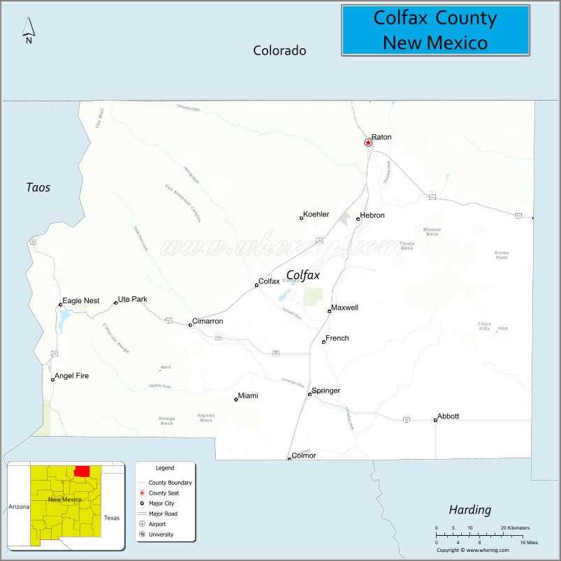
About Colfax County Map, New Mexico: The map showing the county boundary, county seat, major cities, highways, water bodies and neighbouring counties.
Other New Mexico Maps & Info
About Colfax County, New Mexico
Colfax County is a county located in the U.S. state of New Mexico. It's county seat is Raton. As per 2020 census, the population of Colfax County is 12369 people and population density is square miles. According to the United States Census Bureau, the county has a total area of 3,757 sq mi (9,731 km2). Colfax County was established on 1869.
Colfax County Facts
| Continent | North America |
| Country | United States |
| State | New Mexico |
| County Seat | Raton |
| Largest City/Town | Raton |
| Established | 1869 |
| Total Area | 3,768 sq mi (9,759 sq km) |
| Land Area | 3,757 sq mi (9,730 sq km) |
| Water Area | 11 sq mi (29 sq km) |
| Population | 12,444 (Census 2020) |
| Population Density | 3.3 people per sq mi |
| Time Zone | Mountain Time Zone |
| Major Highways | Interstate 25, U.S. Highway 64, U.S. Highway 87, State Road 72, State Road 555 |
| Major Rivers | Canadian River, Cimarron River, Vermejo River |
| Neighboring Counties | Taos County, Mora County, Harding County, Union County, Las Animas County (Colorado) |
| Famous For | Philmont Scout Ranch, Raton Pass, volcanic scenery, and Old West history |
| Top Attractions | Philmont Scout Ranch, Capulin Volcano National Monument, Sugarite Canyon State Park, and Raton Pass |
| Official Website | Official Website |
About Colfax County, New Mexico
Colfax County is located in northeastern New Mexico near the Colorado border and was established in 1869. The county seat is Raton, which is also the largest city and a historic transportation hub along Interstate 25 and the Santa Fe Trail region. The county is known for mountain landscapes, volcanic terrain, ranching, outdoor recreation, and famous scouting destinations.
Cities and Towns in Colfax County, New Mexico
| City/Town | Population (Census 2020) | Latitude & Longitude |
|---|---|---|
| Raton (county seat) | 6,041 | 36.9031°N, 104.4392°W |
| Springer | 940 | 36.3614°N, 104.5955°W |
| Cimarron | 826 | 36.5103°N, 104.9153°W |
| Eagle Nest | 290 | 36.5550°N, 105.2575°W |
| Angel Fire | 1,130 | 36.3931°N, 105.2850°W |
| Maxwell | 794 | 36.5417°N, 104.5403°W |
| Red River (partly) | 465 | 36.7061°N, 105.4022°W |
| Black Lake (CDP) | 66 | 36.5317°N, 105.2570°W |
| Miami (CDP) | 539 | 36.3623°N, 104.6067°W |
| Ute Park (CDP) | 71 | 36.5584°N, 104.9612°W |
| Vermejo Park (CDP) | 29 | 36.8828°N, 105.0295°W |
Golf Courses in Colfax County, New Mexico
| Golf Course | Location | Latitude & Longitude |
|---|---|---|
| Angel Fire Resort Golf Course | Angel Fire | 36.3820°N, 105.2868°W |
| Raton Country Club and Golf Course | Raton | 36.8903°N, 104.4367°W |
| Eagle Nest Golf Course | Eagle Nest | 36.5484°N, 105.2586°W |
| Cimarron Golf Resort | Cimarron | 36.5098°N, 104.9144°W |
Roads and Highways in Colfax County, New Mexico
Major highways connect the county to nearby regions and cities.
- Interstate 25 - major north-south interstate connecting Raton with Colorado and Albuquerque
- U.S. Highway 64 - scenic route linking Cimarron, Eagle Nest, and Taos
- U.S. Highway 87 - connects Raton with Texas and southeastern Colorado
- State Road 72 - highway serving Maxwell and eastern ranching communities
- State Road 555 - route leading toward Philmont Scout Ranch and mountain recreation areas
Neighboring Counties of Colfax County
- Las Animas County, Colorado (north)
- Union County (east)
- Harding County (south)
- Mora County (southwest)
- Taos County (west)
Top Attractions in Colfax County, New Mexico
The county offers a mix of natural and cultural attractions.
- Philmont Scout Ranch - world-famous Boy Scouts adventure ranch with hiking and wilderness programs
- Capulin Volcano National Monument - extinct volcanic cone with panoramic mountain views
- Sugarite Canyon State Park - scenic park with forests, lakes, and hiking trails near Raton
- Raton Pass - historic mountain pass along the Santa Fe Trail and Interstate 25
- Angel Fire Resort - ski resort and year-round recreation destination
- Eagle Nest Lake State Park - fishing, boating, and camping area in the Sangre de Cristo Mountains
- Cimarron Historic District - Old West town with historic buildings and museums
- Vietnam Veterans Memorial State Park - memorial and museum honoring military service members
- Vermejo Park Ranch - expansive wilderness ranch with wildlife and outdoor recreation
- Old Pass Gallery and Museum - museum showcasing regional history and railroad heritage
- Colfax Tavern and Historic Sites - preserved Old West landmarks in Springer and surrounding towns
- Red River Scenic Drives - mountain routes with forests, rivers, and alpine scenery
Distance from Colfax County to Nearby Cities
The following distances are measured by road (driving).
- Raton to Trinidad (Las Animas County), Colorado - 26 mi (42 km)
- Raton to Santa Fe (Santa Fe County), New Mexico - 156 mi (251 km)
- Raton to Albuquerque (Bernalillo County), New Mexico - 239 mi (385 km)
- Raton to Taos (Taos County), New Mexico - 112 mi (180 km)
- Raton to Pueblo (Pueblo County), Colorado - 122 mi (196 km)
- Raton to Colorado Springs (El Paso County), Colorado - 166 mi (267 km)
- Raton to Denver (Denver County), Colorado - 252 mi (406 km)
- Raton to Clayton (Union County), New Mexico - 85 mi (137 km)
- Raton to Las Vegas (San Miguel County), New Mexico - 84 mi (135 km)
- Raton to Amarillo (Potter County), Texas - 279 mi (449 km)
- Raton to Dodge City (Ford County), Kansas - 244 mi (393 km)
- Raton to Farmington (San Juan County), New Mexico - 326 mi (525 km)
FAQs about Colfax County
Colfax County is located in northeastern New Mexico near the Colorado border.
The population of Colfax County was 12,444 according to the Census 2020.
Colfax County is known for Philmont Scout Ranch, mountain scenery, volcanic landscapes, and Old West history.
The county is served by Interstate 25, U.S. Highway 64, U.S. Highway 87, and several scenic state roads.
Yes, Colfax County has golf facilities including Angel Fire Resort Golf Course and Raton Country Club.
References
- QuickFacts - U.S. Census Bureau
- United States Census Bureau
- United States Geological Survey (USGS)
- National Geodetic Survey
- Official County Website
- Bernalillo County Map
- Catron County Map
- Chaves County Map
- Cibola County Map
- Colfax County Map
- Curry County Map
- De Baca County Map
- Doña Ana County Map
- Eddy County Map
- Grant County Map
- Guadalupe County Map
- Harding County Map
- Hidalgo County Map
- Lea County Map
- Lincoln County Map
- Los Alamos County Map
- Luna County Map
- McKinley County Map
- Mora County Map
- Otero County Map
- Quay County Map
- Rio Arriba County Map
- Roosevelt County Map
- Sandoval County Map
- San Juan County Map
- San Miguel County Map
- Santa Fe County Map
- Sierra County Map
- Socorro County Map
- Taos County Map
- Torrance County Map
- Union County Map
- Valencia County Map
- Alabama Counties
- Alaska boroughs
- Arizona Counties
- Arkansas Counties
- California County Map
- Colorado Counties
- Connecticut Counties
- Delaware Counties
- Florida County Map
- Georgia County Map
- Hawaii Counties
- Idaho Counties
- Illinois Counties
- Indiana Counties
- Iowa Counties
- Kansas Counties
- Kentucky Counties
- Louisiana Counties
- Maine Counties
- Maryland Counties
- Massachusetts Counties
- Michigan County Map
- Minnesota Counties
- Mississippi Counties
- Missouri Counties
- Montana Counties
- Nebraska Counties
- Nevada Counties
- New York Counties
- New Hampshire Counties
- New Jersey Counties
- New Mexico Counties
- North Carolina Counties
- North Dakota Counties
- Ohio County Map
- Oklahoma Counties
- Oregon Counties
- Pennsylvania Counties
- Rhode Island Counties
- South Carolina Counties
- South Dakota Counties
- Map of Tennessee
- Texas County Map
- Utah Counties
- Vermont Counties
- Virginia Counties
- Washington Counties
- West Virginia Counties
- Wisconsin Counties
- Wyoming Counties