Written and Fact-checked by Whereig Editors, Reviewed by Mukesh Kumar| Updated On: May 15, 2026
Map of Santa Fe County - Santa Fe County is a county located in the U.S. state of New Mexico. Santa Fe County Map showing cities, highways, important places and water bodies. Get Where is Santa Fe County located in the map, major cities in Santa Fe county, population, areas, and places of interest.
Map of Santa Fe County, New Mexico
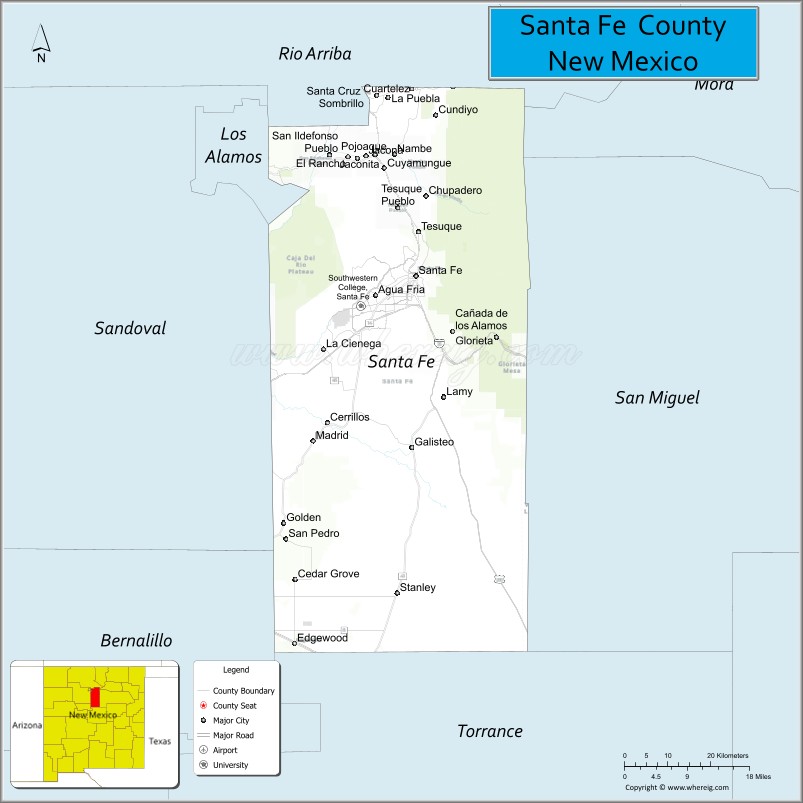
About Santa Fe County Map, New Mexico: The map showing the county boundary, county seat, major cities, highways, water bodies and neighbouring counties.
Other New Mexico Maps & Info
About Santa Fe County, New Mexico
Santa Fe County is a county located in the U.S. state of New Mexico. It's county seat is Santa Fe. As per 2020 census, the population of Santa Fe County is 155201 people and population density is square miles. According to the United States Census Bureau, the county has a total area of 1,909 sq mi (4,944 km2). Santa Fe County was established on 1852.
Santa Fe County Facts
| Continent | North America |
| Country | United States |
| State | New Mexico |
| County Seat | Santa Fe |
| Largest City/Town | Santa Fe |
| Established | 1852 |
| Total Area | 1,911 sq mi (4,950 sq km) |
| Land Area | 1,909 sq mi (4,944 sq km) |
| Water Area | 2 sq mi (6 sq km) |
| Population | 154,823 (Census 2020) |
| Population Density | 81.1 people per sq mi |
| Time Zone | Mountain Time Zone |
| Major Highways | Interstate 25, U.S. Highway 84, U.S. Highway 285, U.S. Highway 285/84, State Road 14 |
| Major Rivers | Rio Grande, Santa Fe River, Pecos River tributaries |
| Neighboring Counties | Rio Arriba County, Los Alamos County, Sandoval County, Bernalillo County, Torrance County, San Miguel County, Mora County |
| Famous For | Historic Santa Fe, adobe architecture, art galleries, Native American culture, and the Santa Fe Plaza |
| Top Attractions | Santa Fe Plaza, Canyon Road, Georgia O’Keeffe Museum, and Meow Wolf |
| Official Website | Official Website |
About Santa Fe County, New Mexico
Santa Fe County is located in north-central New Mexico and was established in 1852 during the territorial period. The county seat and largest city is Santa Fe, the capital of New Mexico and one of the oldest cities in the United States. The county is internationally known for adobe architecture, art galleries, Native American and Hispanic heritage, mountain scenery, and cultural festivals.
Cities and Towns in Santa Fe County, New Mexico
| City/Town | Population (Census 2020) | Latitude & Longitude |
|---|---|---|
| Santa Fe (county seat) | 87,505 | 35.6870°N, 105.9378°W |
| Eldorado at Santa Fe | 6,130 | 35.5264°N, 105.8950°W |
| Edgewood (partly) | 6,194 | 35.0617°N, 106.1914°W |
| Pojoaque | 1,907 | 35.8931°N, 106.0228°W |
| Tesuque | 1,070 | 35.7611°N, 105.9303°W |
| Madrid | 204 | 35.4111°N, 106.1517°W |
| Cerrillos | 229 | 35.4386°N, 106.1261°W |
| Lamy | 218 | 35.4842°N, 105.8797°W |
| Glorieta | 430 | 35.5795°N, 105.7570°W |
| La Cienega | 2,217 | 35.5617°N, 106.1403°W |
Golf Courses in Santa Fe County, New Mexico
| Golf Course | Location | Latitude & Longitude |
|---|---|---|
| Marty Sanchez Links de Santa Fe | Santa Fe | 35.6450°N, 106.0328°W |
| Santa Fe Country Club | Santa Fe | 35.6228°N, 106.0961°W |
| Las Campanas Golf Club | Santa Fe | 35.7481°N, 106.0408°W |
| Quail Run Golf Course | Santa Fe | 35.6511°N, 105.9731°W |
Roads and Highways in Santa Fe County, New Mexico
Major highways connect the county to Albuquerque, northern New Mexico, and surrounding mountain regions.
- Interstate 25 - major north-south interstate connecting Santa Fe with Albuquerque and Las Vegas
- U.S. Highway 84 - regional highway linking Santa Fe with Española and eastern New Mexico
- U.S. Highway 285 - major route connecting Santa Fe with southern Colorado and central New Mexico
- State Road 14 - scenic Turquoise Trail route connecting Santa Fe with Albuquerque
Neighboring Counties of Santa Fe County
- Rio Arriba County (north)
- Los Alamos County (northwest)
- Sandoval County (west)
- Bernalillo County (southwest)
- Torrance County (south)
- San Miguel County (east)
- Mora County (northeast)
Top Attractions in Santa Fe County, New Mexico
The county offers a mix of cultural, artistic, and outdoor attractions.
- Santa Fe Plaza - historic heart of the city surrounded by adobe landmarks and shops
- Canyon Road - famous art district with galleries, studios, and restaurants
- Georgia O’Keeffe Museum - museum dedicated to the celebrated American artist
- Meow Wolf House of Eternal Return - immersive art installation and entertainment venue
- Palace of the Governors - historic adobe building and New Mexico history museum
- Loretto Chapel - landmark chapel known for its spiral staircase
- Santa Fe Opera - internationally recognized outdoor opera venue
- Bandelier National Monument nearby - cliff dwellings and archaeological trails
- Turquoise Trail Scenic Byway - historic scenic drive through mining towns
- Ski Santa Fe - mountain ski resort in the Sangre de Cristo Mountains
- Museum Hill - complex of museums featuring Native American and folk art
- Pecos National Historical Park nearby - cultural and Civil War history landmark
Distance from Santa Fe County to Nearby Cities
The following distances are measured by road (driving).
- Santa Fe to Albuquerque (Bernalillo County), New Mexico - 64 mi (103 km)
- Santa Fe to Española (Rio Arriba County), New Mexico - 26 mi (42 km)
- Santa Fe to Los Alamos (Los Alamos County), New Mexico - 36 mi (58 km)
- Santa Fe to Taos (Taos County), New Mexico - 70 mi (113 km)
- Santa Fe to Las Vegas (San Miguel County), New Mexico - 65 mi (105 km)
- Santa Fe to Farmington (San Juan County), New Mexico - 215 mi (346 km)
- Santa Fe to Roswell (Chaves County), New Mexico - 193 mi (311 km)
- Santa Fe to El Paso (El Paso County), Texas - 273 mi (439 km)
- Santa Fe to Amarillo (Potter County), Texas - 282 mi (454 km)
- Santa Fe to Denver (Denver County), Colorado - 392 mi (631 km)
- Santa Fe to Phoenix (Maricopa County), Arizona - 479 mi (771 km)
- Santa Fe to Tucson (Pima County), Arizona - 553 mi (890 km)
FAQs about Santa Fe County
Santa Fe County is located in north-central New Mexico and includes the state capital region.
The population of Santa Fe County was 154,823 according to the Census 2020.
Santa Fe County is known for historic adobe architecture, art galleries, Native American culture, and the city of Santa Fe.
The county is served by Interstate 25, U.S. Highway 84, U.S. Highway 285, and State Road 14.
Yes, Santa Fe County has several golf facilities including Marty Sanchez Links de Santa Fe and Las Campanas Golf Club.
References
- QuickFacts - U.S. Census Bureau
- United States Census Bureau
- United States Geological Survey (USGS)
- National Geodetic Survey
- Official County Website
- Bernalillo County Map
- Catron County Map
- Chaves County Map
- Cibola County Map
- Colfax County Map
- Curry County Map
- De Baca County Map
- Doña Ana County Map
- Eddy County Map
- Grant County Map
- Guadalupe County Map
- Harding County Map
- Hidalgo County Map
- Lea County Map
- Lincoln County Map
- Los Alamos County Map
- Luna County Map
- McKinley County Map
- Mora County Map
- Otero County Map
- Quay County Map
- Rio Arriba County Map
- Roosevelt County Map
- Sandoval County Map
- San Juan County Map
- San Miguel County Map
- Santa Fe County Map
- Sierra County Map
- Socorro County Map
- Taos County Map
- Torrance County Map
- Union County Map
- Valencia County Map
- Alabama Counties
- Alaska boroughs
- Arizona Counties
- Arkansas Counties
- California County Map
- Colorado Counties
- Connecticut Counties
- Delaware Counties
- Florida County Map
- Georgia County Map
- Hawaii Counties
- Idaho Counties
- Illinois Counties
- Indiana Counties
- Iowa Counties
- Kansas Counties
- Kentucky Counties
- Louisiana Counties
- Maine Counties
- Maryland Counties
- Massachusetts Counties
- Michigan County Map
- Minnesota Counties
- Mississippi Counties
- Missouri Counties
- Montana Counties
- Nebraska Counties
- Nevada Counties
- New York Counties
- New Hampshire Counties
- New Jersey Counties
- New Mexico Counties
- North Carolina Counties
- North Dakota Counties
- Ohio County Map
- Oklahoma Counties
- Oregon Counties
- Pennsylvania Counties
- Rhode Island Counties
- South Carolina Counties
- South Dakota Counties
- Map of Tennessee
- Texas County Map
- Utah Counties
- Vermont Counties
- Virginia Counties
- Washington Counties
- West Virginia Counties
- Wisconsin Counties
- Wyoming Counties