Written and Fact-checked by Whereig Editors, Reviewed by Mukesh Kumar| Updated On: May 15, 2026
Map of Curry County - Curry County is a county located in the U.S. state of New Mexico. Curry County Map showing cities, highways, important places and water bodies. Get Where is Curry County located in the map, major cities in Curry county, population, areas, and places of interest.
Map of Curry County, New Mexico
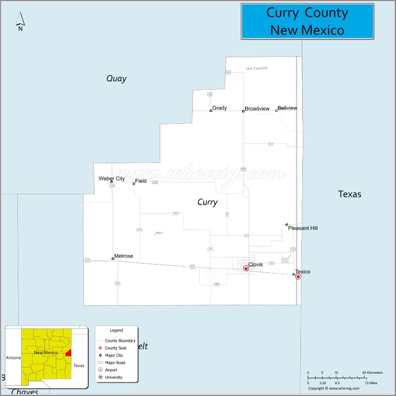
About Curry County Map, New Mexico: The map showing the county boundary, county seat, major cities, highways, water bodies and neighbouring counties.
Other New Mexico Maps & Info
About Curry County, New Mexico
Curry County is a county located in the U.S. state of New Mexico. It's county seat is Clovis. As per 2020 census, the population of Curry County is 47999 people and population density is square miles. According to the United States Census Bureau, the county has a total area of 1,406 sq mi (3,642 km2). Curry County was established on 1909.
Curry County Facts
| Continent | North America |
| Country | United States |
| State | New Mexico |
| County Seat | Clovis |
| Largest City/Town | Clovis |
| Established | 1909 |
| Total Area | 1,408 sq mi (3,647 sq km) |
| Land Area | 1,408 sq mi (3,647 sq km) |
| Water Area | 0.2 sq mi (0.5 sq km) |
| Population | 48,430 (Census 2020) |
| Population Density | 34.4 people per sq mi |
| Time Zone | Mountain Time Zone |
| Major Highways | U.S. Highway 60, U.S. Highway 70, U.S. Highway 84, State Road 209, State Road 523 |
| Major Rivers | No major permanent rivers; seasonal playa lakes and drainage basins |
| Neighboring Counties | Roosevelt County, De Baca County, Quay County, Bailey County (Texas), Parmer County (Texas) |
| Famous For | Cannon Air Force Base, agriculture, rock and roll history, and the Clovis archaeological culture |
| Top Attractions | Hillcrest Park Zoo, Norman and Vi Petty Rock & Roll Museum, Cannon Air Force Base Museum, and Ned Houk Park |
| Official Website | Official Website |
About Curry County, New Mexico
Curry County is located in eastern New Mexico along the Texas border and was established in 1909. The county seat is Clovis, which is also the largest city and a major regional center for agriculture, education, and military activity. The county is known for dairy farming, ranching, music history, and wide-open High Plains landscapes.
Cities and Towns in Curry County, New Mexico
| City/Town | Population (Census 2020) | Latitude & Longitude |
|---|---|---|
| Clovis (county seat) | 37,612 | 34.4048°N, 103.2052°W |
| Texico | 1,065 | 34.3881°N, 103.0422°W |
| Melrose | 651 | 34.4317°N, 103.6305°W |
| Grady | 107 | 34.8237°N, 103.3177°W |
| Cannon AFB (CDP) | 2,899 | 34.3820°N, 103.3228°W |
| Ned Houk Park (CDP) | Small community | 34.5070°N, 103.2512°W |
Golf Courses in Curry County, New Mexico
| Golf Course | Location | Latitude & Longitude |
|---|---|---|
| Colonial Park Golf Course | Clovis | 34.4264°N, 103.2108°W |
| Clovis Municipal Golf Course | Clovis | 34.4142°N, 103.1945°W |
| Rockwind Community Links | Clovis | 34.3918°N, 103.2042°W |
Roads and Highways in Curry County, New Mexico
Major highways connect the county to nearby regions and cities.
- U.S. Highway 60 - east-west highway connecting Clovis with Amarillo and central New Mexico
- U.S. Highway 70 - regional route linking Clovis with Roswell and western New Mexico
- U.S. Highway 84 - major north-south corridor connecting Clovis with Lubbock and Santa Fe
- State Road 209 - serves rural farming and ranching communities
- State Road 523 - local connector route around Clovis and Cannon Air Force Base
Neighboring Counties of Curry County
- Quay County (northwest)
- De Baca County (west)
- Roosevelt County (southwest)
- Bailey County, Texas (east)
- Parmer County, Texas (southeast)
Top Attractions in Curry County, New Mexico
The county offers a mix of natural and cultural attractions.
- Hillcrest Park Zoo - family-friendly zoo and park complex in Clovis
- Norman and Vi Petty Rock & Roll Museum - museum dedicated to Buddy Holly and music recording history
- Cannon Air Force Base Museum - exhibits covering military aviation and regional air force history
- Ned Houk Park - outdoor recreation area with camping, trails, and disc golf
- Clovis Depot Model Train Museum - railroad museum featuring model train displays and regional rail history
- Blackwater Draw Museum - archaeological site tied to the ancient Clovis culture
- North Plains Mall Area - shopping and dining destination in Clovis
- Green Acres Park - public recreation area with sports fields and walking trails
- Clovis Civic Center - events and convention venue hosting concerts and exhibitions
- Texico Historical Museum - local museum focused on border-town history
- High Plains Scenic Drives - countryside routes showcasing eastern New Mexico prairie landscapes
- Clovis Dragstrip - motorsports attraction popular for regional racing events
Distance from Curry County to Nearby Cities
The following distances are measured by road (driving).
- Clovis to Portales (Roosevelt County), New Mexico - 19 mi (31 km)
- Clovis to Roswell (Chaves County), New Mexico - 112 mi (180 km)
- Clovis to Amarillo (Potter County), Texas - 108 mi (174 km)
- Clovis to Lubbock (Lubbock County), Texas - 104 mi (167 km)
- Clovis to Albuquerque (Bernalillo County), New Mexico - 220 mi (354 km)
- Clovis to Santa Fe (Santa Fe County), New Mexico - 228 mi (367 km)
- Clovis to Tucumcari (Quay County), New Mexico - 82 mi (132 km)
- Clovis to Hobbs (Lea County), New Mexico - 116 mi (187 km)
- Clovis to Midland (Midland County), Texas - 221 mi (356 km)
- Clovis to El Paso (El Paso County), Texas - 292 mi (470 km)
- Clovis to Wichita Falls (Wichita County), Texas - 221 mi (356 km)
- Clovis to Oklahoma City (Oklahoma County), Oklahoma - 286 mi (460 km)
FAQs about Curry County
Curry County is located in eastern New Mexico along the Texas border.
The population of Curry County was 48,430 according to the Census 2020.
Curry County is known for Cannon Air Force Base, dairy farming, music history, and the Clovis archaeological culture.
The county is served by U.S. Highway 60, U.S. Highway 70, U.S. Highway 84, and several state roads.
Yes, Curry County has golf facilities including Colonial Park Golf Course and Rockwind Community Links in Clovis.
References
- QuickFacts - U.S. Census Bureau
- United States Census Bureau
- United States Geological Survey (USGS)
- National Geodetic Survey
- Official County Website
- Bernalillo County Map
- Catron County Map
- Chaves County Map
- Cibola County Map
- Colfax County Map
- Curry County Map
- De Baca County Map
- Doña Ana County Map
- Eddy County Map
- Grant County Map
- Guadalupe County Map
- Harding County Map
- Hidalgo County Map
- Lea County Map
- Lincoln County Map
- Los Alamos County Map
- Luna County Map
- McKinley County Map
- Mora County Map
- Otero County Map
- Quay County Map
- Rio Arriba County Map
- Roosevelt County Map
- Sandoval County Map
- San Juan County Map
- San Miguel County Map
- Santa Fe County Map
- Sierra County Map
- Socorro County Map
- Taos County Map
- Torrance County Map
- Union County Map
- Valencia County Map
- Alabama Counties
- Alaska boroughs
- Arizona Counties
- Arkansas Counties
- California County Map
- Colorado Counties
- Connecticut Counties
- Delaware Counties
- Florida County Map
- Georgia County Map
- Hawaii Counties
- Idaho Counties
- Illinois Counties
- Indiana Counties
- Iowa Counties
- Kansas Counties
- Kentucky Counties
- Louisiana Counties
- Maine Counties
- Maryland Counties
- Massachusetts Counties
- Michigan County Map
- Minnesota Counties
- Mississippi Counties
- Missouri Counties
- Montana Counties
- Nebraska Counties
- Nevada Counties
- New York Counties
- New Hampshire Counties
- New Jersey Counties
- New Mexico Counties
- North Carolina Counties
- North Dakota Counties
- Ohio County Map
- Oklahoma Counties
- Oregon Counties
- Pennsylvania Counties
- Rhode Island Counties
- South Carolina Counties
- South Dakota Counties
- Map of Tennessee
- Texas County Map
- Utah Counties
- Vermont Counties
- Virginia Counties
- Washington Counties
- West Virginia Counties
- Wisconsin Counties
- Wyoming Counties