Written and Fact-checked by Whereig Editors, Reviewed by Mukesh Kumar| Updated On: May 15, 2026
Map of San Miguel County - San Miguel County is a county located in the U.S. state of New Mexico. San Miguel County Map showing cities, highways, important places and water bodies. Get Where is San Miguel County located in the map, major cities in San Miguel county, population, areas, and places of interest.
Map of San Miguel County, New Mexico
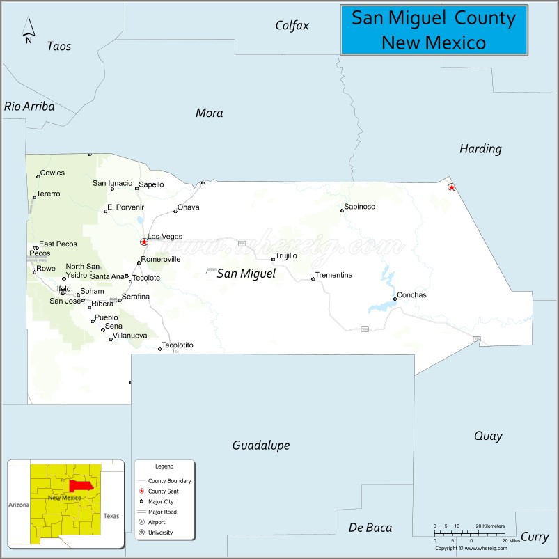
About San Miguel County Map, New Mexico: The map showing the county boundary, county seat, major cities, highways, water bodies and neighbouring counties.
Other New Mexico Maps & Info
About San Miguel County, New Mexico
San Miguel County is a county located in the U.S. state of New Mexico. It's county seat is Las Vegas. As per 2020 census, the population of San Miguel County is 27150 people and population density is square miles. According to the United States Census Bureau, the county has a total area of 4,717 sq mi (12,217 km2). San Miguel County was established on 1852.
San Miguel County Facts
| Continent | North America |
| Country | United States |
| State | New Mexico |
| County Seat | Las Vegas |
| Largest City/Town | Las Vegas |
| Established | 1852 |
| Total Area | 4,736 sq mi (12,266 sq km) |
| Land Area | 4,716 sq mi (12,215 sq km) |
| Water Area | 20 sq mi (52 sq km) |
| Population | 27,117 (Census 2020) |
| Population Density | 5.7 people per sq mi |
| Time Zone | Mountain Time Zone |
| Major Highways | Interstate 25, Interstate 40, U.S. Highway 84, State Road 518 |
| Major Rivers | Pecos River, Gallinas River, Canadian River tributaries |
| Neighboring Counties | Mora County, Harding County, Quay County, Guadalupe County, Torrance County, Santa Fe County, Taos County |
| Famous For | Historic Las Vegas, Old West heritage, mountain landscapes, and hot springs |
| Top Attractions | Las Vegas Historic District, Pecos National Historical Park nearby, Storrie Lake, and Montezuma Castle |
| Official Website | Official Website |
About San Miguel County, New Mexico
San Miguel County is located in northeastern New Mexico and was established in 1852 during the territorial period. The county seat and largest city is Las Vegas, one of the state's most historic communities with preserved Old West architecture and cultural heritage. The county is known for mountain scenery, ranching traditions, historic landmarks, and scenic river valleys.
Cities and Towns in San Miguel County, New Mexico
| City/Town | Population (Census 2020) | Latitude & Longitude |
|---|---|---|
| Las Vegas (county seat) | 13,166 | 35.5939°N, 105.2239°W |
| Pecos | 1,328 | 35.5778°N, 105.6750°W |
| Montezuma | Small historic village | 35.6523°N, 105.2775°W |
| Ribera | 314 | 35.3745°N, 105.4953°W |
| Rowe | 412 | 35.4997°N, 105.6664°W |
| Conchas Dam | 186 | 35.4050°N, 104.1931°W |
| Villanueva | 233 | 35.2697°N, 105.3520°W |
| Trementina | Rural community | 35.4608°N, 104.4847°W |
| Romero | Historic settlement | 35.6345°N, 105.1853°W |
| Tecolotito | Small community | 35.4875°N, 105.2292°W |
Golf Courses in San Miguel County, New Mexico
| Golf Course | Location | Latitude & Longitude |
|---|---|---|
| Gene Torres Golf Course | Las Vegas | 35.6011°N, 105.2108°W |
| Pecos Valley Recreation Golf Area | Pecos | 35.5792°N, 105.6744°W |
Roads and Highways in San Miguel County, New Mexico
Major highways connect the county to central New Mexico, the High Plains, and mountain communities.
- Interstate 25 - major north-south interstate connecting Las Vegas with Santa Fe and Raton
- Interstate 40 - east-west interstate crossing the southern portion of the county
- U.S. Highway 84 - highway linking Las Vegas with Santa Fe and eastern New Mexico
- State Road 518 - scenic mountain route connecting Las Vegas with Mora and Taos regions
Neighboring Counties of San Miguel County
- Mora County (north)
- Harding County (northeast)
- Quay County (east)
- Guadalupe County (south)
- Torrance County (southwest)
- Santa Fe County (west)
- Taos County (northwest)
Top Attractions in San Miguel County, New Mexico
The county offers a mix of historical, cultural, and outdoor attractions.
- Las Vegas Historic District - preserved Victorian and Old West architecture
- Montezuma Castle - historic landmark and former luxury resort near hot springs
- Storrie Lake State Park - recreation area popular for boating, fishing, and camping
- Pecos National Historical Park nearby - archaeological and Civil War history site
- Villanueva State Park - scenic canyon park along the Pecos River
- Montezuma Hot Springs - historic thermal spring area near Las Vegas
- Gallinas River Recreation Areas - fishing and hiking opportunities
- Las Vegas Plaza - historic town square with cultural landmarks
- Conchas Lake nearby - reservoir known for boating and fishing
- New Mexico Highlands University - historic university campus and cultural center
- Hermit's Peak wilderness scenery - mountain hiking and outdoor recreation
- Historic Route 66 corridors - vintage roadside attractions and scenic drives
Distance from San Miguel County to Nearby Cities
The following distances are measured by road (driving).
- Las Vegas to Santa Fe (Santa Fe County), New Mexico - 65 mi (105 km)
- Las Vegas to Albuquerque (Bernalillo County), New Mexico - 122 mi (196 km)
- Las Vegas to Raton (Colfax County), New Mexico - 83 mi (134 km)
- Las Vegas to Tucumcari (Quay County), New Mexico - 118 mi (190 km)
- Las Vegas to Taos (Taos County), New Mexico - 131 mi (211 km)
- Las Vegas to Roswell (Chaves County), New Mexico - 184 mi (296 km)
- Las Vegas to Amarillo (Potter County), Texas - 245 mi (394 km)
- Las Vegas to Denver (Denver County), Colorado - 331 mi (533 km)
- Las Vegas to El Paso (El Paso County), Texas - 334 mi (537 km)
- Las Vegas to Phoenix (Maricopa County), Arizona - 468 mi (753 km)
- Las Vegas to Oklahoma City (Oklahoma County), Oklahoma - 402 mi (647 km)
- Las Vegas to Tucson (Pima County), Arizona - 542 mi (872 km)
FAQs about San Miguel County
San Miguel County is located in northeastern New Mexico between the High Plains and mountain regions.
The population of San Miguel County was 27,117 according to the Census 2020.
San Miguel County is known for historic Las Vegas, Old West architecture, scenic mountain landscapes, and hot springs.
The county is served by Interstate 25, Interstate 40, U.S. Highway 84, and State Road 518.
Yes, San Miguel County has golf facilities including Gene Torres Golf Course in Las Vegas.
References
- QuickFacts - U.S. Census Bureau
- United States Census Bureau
- United States Geological Survey (USGS)
- National Geodetic Survey
- Official County Website
- Bernalillo County Map
- Catron County Map
- Chaves County Map
- Cibola County Map
- Colfax County Map
- Curry County Map
- De Baca County Map
- Doña Ana County Map
- Eddy County Map
- Grant County Map
- Guadalupe County Map
- Harding County Map
- Hidalgo County Map
- Lea County Map
- Lincoln County Map
- Los Alamos County Map
- Luna County Map
- McKinley County Map
- Mora County Map
- Otero County Map
- Quay County Map
- Rio Arriba County Map
- Roosevelt County Map
- Sandoval County Map
- San Juan County Map
- San Miguel County Map
- Santa Fe County Map
- Sierra County Map
- Socorro County Map
- Taos County Map
- Torrance County Map
- Union County Map
- Valencia County Map
- Alabama Counties
- Alaska boroughs
- Arizona Counties
- Arkansas Counties
- California County Map
- Colorado Counties
- Connecticut Counties
- Delaware Counties
- Florida County Map
- Georgia County Map
- Hawaii Counties
- Idaho Counties
- Illinois Counties
- Indiana Counties
- Iowa Counties
- Kansas Counties
- Kentucky Counties
- Louisiana Counties
- Maine Counties
- Maryland Counties
- Massachusetts Counties
- Michigan County Map
- Minnesota Counties
- Mississippi Counties
- Missouri Counties
- Montana Counties
- Nebraska Counties
- Nevada Counties
- New York Counties
- New Hampshire Counties
- New Jersey Counties
- New Mexico Counties
- North Carolina Counties
- North Dakota Counties
- Ohio County Map
- Oklahoma Counties
- Oregon Counties
- Pennsylvania Counties
- Rhode Island Counties
- South Carolina Counties
- South Dakota Counties
- Map of Tennessee
- Texas County Map
- Utah Counties
- Vermont Counties
- Virginia Counties
- Washington Counties
- West Virginia Counties
- Wisconsin Counties
- Wyoming Counties