Written and Fact-checked by Whereig Editors, Reviewed by Mukesh Kumar| Updated On: May 15, 2026
Map of Torrance County - Torrance County is a county located in the U.S. state of New Mexico. Torrance County Map showing cities, highways, important places and water bodies. Get Where is Torrance County located in the map, major cities in Torrance county, population, areas, and places of interest.
Map of Torrance County, New Mexico
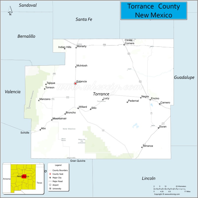
About Torrance County Map, New Mexico: The map showing the county boundary, county seat, major cities, highways, water bodies and neighbouring counties.
Other New Mexico Maps & Info
About Torrance County, New Mexico
Torrance County is a county located in the U.S. state of New Mexico. It's county seat is Estancia. As per 2020 census, the population of Torrance County is 15307 people and population density is square miles. According to the United States Census Bureau, the county has a total area of 3,345 sq mi (8,664 km2). Torrance County was established on 1903.
Torrance County Facts
| Continent | North America |
| Country | United States |
| State | New Mexico |
| County Seat | Estancia |
| Largest City/Town | Moriarty |
| Established | 1903 |
| Total Area | 3,345 sq mi (8,664 sq km) |
| Land Area | 3,345 sq mi (8,664 sq km) |
| Water Area | 0.2 sq mi (0.5 sq km) |
| Population | 16,446 (Census 2020) |
| Population Density | 4.9 people per sq mi |
| Time Zone | Mountain Time Zone (MST/MDT) |
| Major Highways | Interstate 40, U.S. Route 54, U.S. Route 60, U.S. Route 285 |
| Major Rivers | No major permanent rivers |
| Neighboring Counties | Santa Fe County, Bernalillo County, Valencia County, Socorro County, Lincoln County, Guadalupe County, San Miguel County |
| Famous For | Estancia Valley, ranching, farming, historic Route 66 communities |
| Top Attractions | Salinas Pueblo Missions, Manzano Mountains, Moriarty Route 66 sites, Estancia Valley |
| Official Website | Official Website |
About Torrance County, New Mexico
Torrance County is located in the central part of New Mexico in the United States and was established in 1903. The county seat is Estancia, while Moriarty is the largest city. The county includes wide grasslands, agricultural valleys, and mountain landscapes near the Manzano Mountains.
Cities and Towns in Torrance County, New Mexico
| City/Town | Population (Census 2020) | Latitude & Longitude |
|---|---|---|
| Estancia (county seat) | 1,655 | 34.7589°N, 106.0553°W |
| Moriarty | 1,946 | 34.9901°N, 106.0492°W |
| Mountainair | 928 | 34.5209°N, 106.2406°W |
| Willard | 240 | 34.6006°N, 106.0345°W |
| Encino | 44 | 34.6528°N, 105.4625°W |
| Tajique (CDP) | 266 | 34.7639°N, 106.3078°W |
| Punta de Agua (CDP) | 181 | 34.6050°N, 105.9814°W |
| McIntosh (CDP) | 76 | 34.6928°N, 105.9667°W |
| Claunch (CDP) | 35 | 34.1175°N, 106.0728°W |
| Duran (CDP) | 35 | 34.4661°N, 105.4078°W |
| Corona (CDP) | 172 | 34.2508°N, 105.5964°W |
Golf Courses in Torrance County, New Mexico
| Golf Course | Location | Latitude & Longitude |
|---|---|---|
| Mountainair Municipal Golf Course | Mountainair | 34.5181°N, 106.2486°W |
| Moriarty Civic Golf Course | Moriarty | 34.9944°N, 106.0400°W |
Roads and Highways in Torrance County, New Mexico
Major highways connect the county to Albuquerque, eastern New Mexico, and southern regions of the state.
- Interstate 40 - crosses northern Torrance County and connects Moriarty with Albuquerque and Santa Rosa
- U.S. Route 54 - travels southeast through the county toward Carrizozo and Vaughn
- U.S. Route 60 - runs east-west through Mountainair and links the county with Socorro and Fort Sumner
- U.S. Route 285 - passes through Estancia and connects the county with Santa Fe and Roswell
- New Mexico State Road 41 - links Moriarty, Estancia, and Willard through the Estancia Valley
Neighboring Counties of Torrance County
- Santa Fe County (north)
- San Miguel County (northeast)
- Guadalupe County (east)
- Lincoln County (south)
- Socorro County (southwest)
- Valencia County (west)
- Bernalillo County (northwest)
Top Attractions in Torrance County, New Mexico
The county offers a mix of natural and historical attractions.
- Salinas Pueblo Missions National Monument - historic Spanish mission ruins and Native American pueblo sites.
- Manzano Mountains State Park - scenic mountain recreation area with camping and hiking trails.
- Estancia Valley - broad agricultural valley known for ranching and farming landscapes.
- Moriarty Route 66 Attractions - historic roadside businesses and classic highway culture sites.
- Mountainair Historic District - small town area with historic adobe buildings and local museums.
- Quarai Ruins - preserved mission church and pueblo ruins near Mountainair.
- Abo Ruins - historic red sandstone mission ruins with interpretive trails.
- Cibola National Forest - forested recreation areas along the western edge of the county.
- Willard Cantina Museum - local museum featuring ranching and railroad history.
- Gran Quivira Ruins - remote archaeological site with mission remains and panoramic plains views.
Distance from Torrance County to Nearby Cities
The following distances are measured by road (driving).
- Estancia to Albuquerque (Bernalillo County), New Mexico - 58 mi (93 km)
- Estancia to Santa Fe (Santa Fe County), New Mexico - 81 mi (130 km)
- Estancia to Moriarty (Torrance County), New Mexico - 24 mi (39 km)
- Estancia to Mountainair (Torrance County), New Mexico - 28 mi (45 km)
- Estancia to Roswell (Chaves County), New Mexico - 157 mi (253 km)
- Estancia to Las Vegas (San Miguel County), New Mexico - 98 mi (158 km)
- Estancia to Santa Rosa (Guadalupe County), New Mexico - 87 mi (140 km)
- Estancia to Vaughn (Guadalupe County), New Mexico - 77 mi (124 km)
- Estancia to Belen (Valencia County), New Mexico - 62 mi (100 km)
- Estancia to Socorro (Socorro County), New Mexico - 113 mi (182 km)
- Estancia to Clines Corners (Torrance County), New Mexico - 37 mi (60 km)
- Estancia to Carrizozo (Lincoln County), New Mexico - 118 mi (190 km)
FAQs about Torrance County
Torrance County is located in central New Mexico east of Albuquerque.
Torrance County had a population of 16,446 according to the Census 2020.
Torrance County is known for the Estancia Valley, historic mission ruins, ranching, and Route 66 communities.
The major highways include Interstate 40, U.S. Route 54, U.S. Route 60, and U.S. Route 285.
Yes, Torrance County has golf facilities including Moriarty Civic Golf Course and Mountainair Municipal Golf Course.
References
- QuickFacts - U.S. Census Bureau
- United States Census Bureau
- United States Geological Survey (USGS)
- National Geodetic Survey
- Official County Website
- Bernalillo County Map
- Catron County Map
- Chaves County Map
- Cibola County Map
- Colfax County Map
- Curry County Map
- De Baca County Map
- Doña Ana County Map
- Eddy County Map
- Grant County Map
- Guadalupe County Map
- Harding County Map
- Hidalgo County Map
- Lea County Map
- Lincoln County Map
- Los Alamos County Map
- Luna County Map
- McKinley County Map
- Mora County Map
- Otero County Map
- Quay County Map
- Rio Arriba County Map
- Roosevelt County Map
- Sandoval County Map
- San Juan County Map
- San Miguel County Map
- Santa Fe County Map
- Sierra County Map
- Socorro County Map
- Taos County Map
- Torrance County Map
- Union County Map
- Valencia County Map
- Alabama Counties
- Alaska boroughs
- Arizona Counties
- Arkansas Counties
- California County Map
- Colorado Counties
- Connecticut Counties
- Delaware Counties
- Florida County Map
- Georgia County Map
- Hawaii Counties
- Idaho Counties
- Illinois Counties
- Indiana Counties
- Iowa Counties
- Kansas Counties
- Kentucky Counties
- Louisiana Counties
- Maine Counties
- Maryland Counties
- Massachusetts Counties
- Michigan County Map
- Minnesota Counties
- Mississippi Counties
- Missouri Counties
- Montana Counties
- Nebraska Counties
- Nevada Counties
- New York Counties
- New Hampshire Counties
- New Jersey Counties
- New Mexico Counties
- North Carolina Counties
- North Dakota Counties
- Ohio County Map
- Oklahoma Counties
- Oregon Counties
- Pennsylvania Counties
- Rhode Island Counties
- South Carolina Counties
- South Dakota Counties
- Map of Tennessee
- Texas County Map
- Utah Counties
- Vermont Counties
- Virginia Counties
- Washington Counties
- West Virginia Counties
- Wisconsin Counties
- Wyoming Counties