Written and Fact-checked by Whereig Editors, Reviewed by Mukesh Kumar| Updated On: May 15, 2026
Map of Union County - Union County is a county located in the U.S. state of New Mexico. Union County Map showing cities, highways, important places and water bodies. Get Where is Union County located in the map, major cities in Union county, population, areas, and places of interest.
Map of Union County, New Mexico
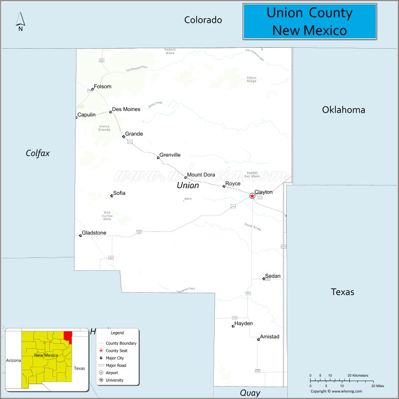
About Union County Map, New Mexico: The map showing the county boundary, county seat, major cities, highways, water bodies and neighbouring counties.
Other New Mexico Maps & Info
About Union County, New Mexico
Union County is a county located in the U.S. state of New Mexico. It's county seat is Clayton. As per 2020 census, the population of Union County is 4107 people and population density is square miles. According to the United States Census Bureau, the county has a total area of 3,830 sq mi (9,920 km2). Union County was established on 1893.
Union County Facts
| Continent | North America |
| Country | United States |
| State | New Mexico |
| County Seat | Clayton |
| Largest City/Town | Clayton |
| Established | 1893 |
| Total Area | 3,831 sq mi (9,922 sq km) |
| Land Area | 3,824 sq mi (9,904 sq km) |
| Water Area | 7 sq mi (18 sq km) |
| Population | 3,928 (Census 2020) |
| Population Density | 1.0 people per sq mi |
| Time Zone | Mountain Time Zone (MST/MDT) |
| Major Highways | U.S. Route 56, U.S. Route 64, U.S. Route 87, New Mexico State Road 402 |
| Major Rivers | Cimarron River, Canadian River tributaries |
| Neighboring Counties | Colfax County, Harding County |
| Famous For | Capulin Volcano, dinosaur tracks, ranching, historic Santa Fe Trail routes |
| Top Attractions | Capulin Volcano National Monument, Clayton Lake State Park, Herzstein Memorial Museum |
| Official Website | Official Website |
About Union County, New Mexico
Union County is located in the northeastern corner of New Mexico in the United States and was established in 1893. The county seat is Clayton, which is also the largest town. The county is known for its open High Plains landscapes, volcanic features, ranching history, and important Santa Fe Trail heritage.
Cities and Towns in Union County, New Mexico
| City/Town | Population (Census 2020) | Latitude & Longitude |
|---|---|---|
| Clayton (county seat) | 2,643 | 36.4517°N, 103.1841°W |
| Des Moines | 143 | 36.7617°N, 103.8347°W |
| Folsom | 51 | 36.8450°N, 103.9172°W |
| Grenville | 22 | 36.5956°N, 103.6072°W |
| Capulin | 63 | 36.7417°N, 103.9986°W |
| Texline (CDP) | 32 | 36.3772°N, 103.0417°W |
| Mount Dora (CDP) | 55 | 36.8153°N, 103.3464°W |
| Seneca (CDP) | 18 | 36.4144°N, 103.7428°W |
Golf Courses in Union County, New Mexico
| Golf Course | Location | Latitude & Longitude |
|---|---|---|
| Clayton Municipal Golf Course | Clayton | 36.4528°N, 103.2033°W |
Roads and Highways in Union County, New Mexico
Major highways connect the county with northeastern New Mexico, Colorado, Oklahoma, and Texas.
- U.S. Route 56 - crosses the county east-west and connects Clayton with Springer and Boise City
- U.S. Route 64 - links Clayton with Raton and the Texas Panhandle
- U.S. Route 87 - travels north-south through Clayton toward Texas and Colorado
- New Mexico State Road 402 - connects rural ranching areas with Clayton and nearby communities
- New Mexico State Road 325 - provides access to Capulin Volcano National Monument
Neighboring Counties of Union County
- Colfax County (west)
- Harding County (southwest)
- Las Animas County, Colorado (north)
- Baca County, Colorado (northeast)
- Cimarron County, Oklahoma (east)
- Dallam County, Texas (southeast)
Top Attractions in Union County, New Mexico
The county offers a mix of natural and historical attractions.
- Capulin Volcano National Monument - extinct volcanic cone with scenic driving roads and panoramic views.
- Clayton Lake State Park - recreation area known for camping, fishing, and dinosaur trackways.
- Herzstein Memorial Museum - local museum featuring pioneer, ranching, and railroad history.
- Santa Fe Trail Historic Sites - preserved wagon trail routes and historical markers across the county.
- Folsom Museum - small museum showcasing the region's archaeology and ranching heritage.
- Des Moines Historic District - quiet plains town with historic buildings and western history.
- Rabbit Ear Mountain - volcanic landmark visible across northeastern New Mexico.
- Black Mesa Scenic Areas - open grassland and canyon landscapes near the Oklahoma border.
- Union County Courthouse - historic county courthouse located in downtown Clayton.
- Clayton Public Observatory - community observatory offering stargazing opportunities under dark skies.
Distance from Union County to Nearby Cities
The following distances are measured by road (driving).
- Clayton to Raton (Colfax County), New Mexico - 87 mi (140 km)
- Clayton to Tucumcari (Quay County), New Mexico - 110 mi (177 km)
- Clayton to Springer (Colfax County), New Mexico - 91 mi (146 km)
- Clayton to Amarillo (Potter County), Texas - 130 mi (209 km)
- Clayton to Dalhart (Dallam County), Texas - 79 mi (127 km)
- Clayton to Boise City (Cimarron County), Oklahoma - 31 mi (50 km)
- Clayton to Trinidad (Las Animas County), Colorado - 91 mi (146 km)
- Clayton to Pueblo (Pueblo County), Colorado - 183 mi (295 km)
- Clayton to Las Vegas (San Miguel County), New Mexico - 145 mi (233 km)
- Clayton to Santa Rosa (Guadalupe County), New Mexico - 177 mi (285 km)
- Clayton to Albuquerque (Bernalillo County), New Mexico - 290 mi (467 km)
- Clayton to Denver (Denver County), Colorado - 290 mi (467 km)
FAQs about Union County
Union County is located in the northeastern corner of New Mexico near Colorado, Oklahoma, and Texas.
Union County had a population of 3,928 according to the Census 2020.
Union County is known for Capulin Volcano, dinosaur tracks, ranching history, and Santa Fe Trail sites.
The major highways include U.S. Route 56, U.S. Route 64, and U.S. Route 87.
Yes, Clayton Municipal Golf Course serves golfers in Union County.
References
- QuickFacts - U.S. Census Bureau
- United States Census Bureau
- United States Geological Survey (USGS)
- National Geodetic Survey
- Official County Website
- Bernalillo County Map
- Catron County Map
- Chaves County Map
- Cibola County Map
- Colfax County Map
- Curry County Map
- De Baca County Map
- Doña Ana County Map
- Eddy County Map
- Grant County Map
- Guadalupe County Map
- Harding County Map
- Hidalgo County Map
- Lea County Map
- Lincoln County Map
- Los Alamos County Map
- Luna County Map
- McKinley County Map
- Mora County Map
- Otero County Map
- Quay County Map
- Rio Arriba County Map
- Roosevelt County Map
- Sandoval County Map
- San Juan County Map
- San Miguel County Map
- Santa Fe County Map
- Sierra County Map
- Socorro County Map
- Taos County Map
- Torrance County Map
- Union County Map
- Valencia County Map
- Alabama Counties
- Alaska boroughs
- Arizona Counties
- Arkansas Counties
- California County Map
- Colorado Counties
- Connecticut Counties
- Delaware Counties
- Florida County Map
- Georgia County Map
- Hawaii Counties
- Idaho Counties
- Illinois Counties
- Indiana Counties
- Iowa Counties
- Kansas Counties
- Kentucky Counties
- Louisiana Counties
- Maine Counties
- Maryland Counties
- Massachusetts Counties
- Michigan County Map
- Minnesota Counties
- Mississippi Counties
- Missouri Counties
- Montana Counties
- Nebraska Counties
- Nevada Counties
- New York Counties
- New Hampshire Counties
- New Jersey Counties
- New Mexico Counties
- North Carolina Counties
- North Dakota Counties
- Ohio County Map
- Oklahoma Counties
- Oregon Counties
- Pennsylvania Counties
- Rhode Island Counties
- South Carolina Counties
- South Dakota Counties
- Map of Tennessee
- Texas County Map
- Utah Counties
- Vermont Counties
- Virginia Counties
- Washington Counties
- West Virginia Counties
- Wisconsin Counties
- Wyoming Counties