Written and Fact-checked by Whereig Editors, Reviewed by Mukesh Kumar| Updated On: May 15, 2026
Map of Quay County - Quay County is a county located in the U.S. state of New Mexico. Quay County Map showing cities, highways, important places and water bodies. Get Where is Quay County located in the map, major cities in Quay county, population, areas, and places of interest.
Map of Quay County, New Mexico
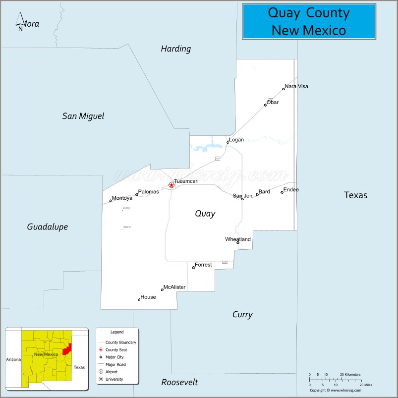
About Quay County Map, New Mexico: The map showing the county boundary, county seat, major cities, highways, water bodies and neighbouring counties.
Other New Mexico Maps & Info
About Quay County, New Mexico
Quay County is a county located in the U.S. state of New Mexico. It's county seat is Tucumcari. As per 2020 census, the population of Quay County is 8656 people and population density is square miles. According to the United States Census Bureau, the county has a total area of 2,855 sq mi (7,394 km2). Quay County was established on 1903.
Quay County Facts
| Continent | North America |
| Country | United States |
| State | New Mexico |
| County Seat | Tucumcari |
| Largest City/Town | Tucumcari |
| Established | 1903 |
| Total Area | 2,882 sq mi (7,464 sq km) |
| Land Area | 2,874 sq mi (7,443 sq km) |
| Water Area | 8 sq mi (21 sq km) |
| Population | 8,746 (Census 2020) |
| Population Density | 3.0 people per sq mi |
| Time Zone | Mountain Time Zone |
| Major Highways | Interstate 40, U.S. Highway 54, U.S. Highway 84, State Road 104 |
| Major Rivers | Canadian River tributaries and Ute Creek |
| Neighboring Counties | Union County, Harding County, Guadalupe County, Curry County, Deaf Smith County (Texas), Oldham County (Texas) |
| Famous For | Route 66 history, Tucumcari mountain landscapes, roadside neon signs, and ranching |
| Top Attractions | Tucumcari Mountain, Route 66 Historic District, Mesalands Dinosaur Museum, and Ute Lake State Park |
| Official Website | Official Website |
About Quay County, New Mexico
Quay County is located in eastern New Mexico along the Texas border region and was established in 1903. The county seat and largest city is Tucumcari, a famous Route 66 community known for its classic roadside architecture and neon motel signs. The county is recognized for ranching, desert mesas, prairie scenery, and historic travel routes across the High Plains.
Cities and Towns in Quay County, New Mexico
| City/Town | Population (Census 2020) | Latitude & Longitude |
|---|---|---|
| Tucumcari (county seat) | 5,278 | 35.1717°N, 103.7241°W |
| Logan | 928 | 35.3656°N, 103.4111°W |
| House | 68 | 34.6495°N, 103.9036°W |
| San Jon | 216 | 35.1078°N, 103.3297°W |
| Nara Visa | Small community | 35.6061°N, 103.1292°W |
| McAlister | Historic settlement | 35.0189°N, 103.6819°W |
| Montoya | Historic community | 35.1539°N, 103.5931°W |
Golf Courses in Quay County, New Mexico
| Golf Course | Location | Latitude & Longitude |
|---|---|---|
| Tucumcari Municipal Golf Course | Tucumcari | 35.1764°N, 103.7280°W |
| Logan Recreation Golf Area | Logan | 35.3670°N, 103.4128°W |
Roads and Highways in Quay County, New Mexico
Major highways connect the county to Texas, central New Mexico, and historic Route 66 communities.
- Interstate 40 - major east-west interstate following the historic Route 66 corridor
- U.S. Highway 54 - north-south route connecting Tucumcari with Amarillo and Santa Rosa
- U.S. Highway 84 - regional route serving eastern New Mexico ranching communities
- State Road 104 - scenic road linking Tucumcari with Las Vegas and Conchas Lake areas
Neighboring Counties of Quay County
- Union County (north)
- Harding County (west)
- Guadalupe County (southwest)
- Curry County (south)
- Deaf Smith County, Texas (southeast)
- Oldham County, Texas (east)
Top Attractions in Quay County, New Mexico
The county offers a mix of historical and outdoor attractions.
- Tucumcari Mountain - iconic mesa landmark overlooking the city and Route 66 corridor
- Route 66 Historic District - classic motels, neon signs, and roadside attractions in Tucumcari
- Mesalands Dinosaur Museum and Natural Sciences Laboratory - dinosaur exhibits and fossil collections
- Ute Lake State Park - recreation area known for boating, fishing, and camping
- Tee Pee Curios - famous Route 66 souvenir and roadside landmark
- Tucumcari Historical Museum - exhibits covering local ranching and railroad history
- Conchas Lake nearby - reservoir popular for water recreation and fishing
- Nara Visa Route 66 Museum - small museum dedicated to Route 66 heritage
- Logan Historic District - historic community near Ute Lake with western charm
- Canadian River Scenic Areas - prairie landscapes and wildlife observation spots
- Murals of Tucumcari - colorful public art celebrating local history and culture
- Eastern New Mexico Prairie Drives - scenic open-road landscapes and ranching country
Distance from Quay County to Nearby Cities
The following distances are measured by road (driving).
- Tucumcari to Santa Rosa (Guadalupe County), New Mexico - 59 mi (95 km)
- Tucumcari to Clovis (Curry County), New Mexico - 96 mi (154 km)
- Tucumcari to Amarillo (Potter County), Texas - 113 mi (182 km)
- Tucumcari to Albuquerque (Bernalillo County), New Mexico - 176 mi (283 km)
- Tucumcari to Las Vegas (San Miguel County), New Mexico - 118 mi (190 km)
- Tucumcari to Santa Fe (Santa Fe County), New Mexico - 177 mi (285 km)
- Tucumcari to Lubbock (Lubbock County), Texas - 177 mi (285 km)
- Tucumcari to Oklahoma City (Oklahoma County), Oklahoma - 280 mi (451 km)
- Tucumcari to Roswell (Chaves County), New Mexico - 158 mi (254 km)
- Tucumcari to Denver (Denver County), Colorado - 387 mi (623 km)
- Tucumcari to El Paso (El Paso County), Texas - 352 mi (566 km)
- Tucumcari to Phoenix (Maricopa County), Arizona - 557 mi (896 km)
FAQs about Quay County
Quay County is located in eastern New Mexico along the historic Route 66 corridor.
The population of Quay County was 8,746 according to the Census 2020.
Quay County is known for Route 66 history, Tucumcari neon signs, prairie landscapes, and ranching heritage.
The county is served by Interstate 40, U.S. Highway 54, U.S. Highway 84, and State Road 104.
Yes, Quay County has golf facilities including Tucumcari Municipal Golf Course.
References
- QuickFacts - U.S. Census Bureau
- United States Census Bureau
- United States Geological Survey (USGS)
- National Geodetic Survey
- Official County Website
- Bernalillo County Map
- Catron County Map
- Chaves County Map
- Cibola County Map
- Colfax County Map
- Curry County Map
- De Baca County Map
- Doña Ana County Map
- Eddy County Map
- Grant County Map
- Guadalupe County Map
- Harding County Map
- Hidalgo County Map
- Lea County Map
- Lincoln County Map
- Los Alamos County Map
- Luna County Map
- McKinley County Map
- Mora County Map
- Otero County Map
- Quay County Map
- Rio Arriba County Map
- Roosevelt County Map
- Sandoval County Map
- San Juan County Map
- San Miguel County Map
- Santa Fe County Map
- Sierra County Map
- Socorro County Map
- Taos County Map
- Torrance County Map
- Union County Map
- Valencia County Map
- Alabama Counties
- Alaska boroughs
- Arizona Counties
- Arkansas Counties
- California County Map
- Colorado Counties
- Connecticut Counties
- Delaware Counties
- Florida County Map
- Georgia County Map
- Hawaii Counties
- Idaho Counties
- Illinois Counties
- Indiana Counties
- Iowa Counties
- Kansas Counties
- Kentucky Counties
- Louisiana Counties
- Maine Counties
- Maryland Counties
- Massachusetts Counties
- Michigan County Map
- Minnesota Counties
- Mississippi Counties
- Missouri Counties
- Montana Counties
- Nebraska Counties
- Nevada Counties
- New York Counties
- New Hampshire Counties
- New Jersey Counties
- New Mexico Counties
- North Carolina Counties
- North Dakota Counties
- Ohio County Map
- Oklahoma Counties
- Oregon Counties
- Pennsylvania Counties
- Rhode Island Counties
- South Carolina Counties
- South Dakota Counties
- Map of Tennessee
- Texas County Map
- Utah Counties
- Vermont Counties
- Virginia Counties
- Washington Counties
- West Virginia Counties
- Wisconsin Counties
- Wyoming Counties