Written and Fact-checked by Whereig Editors, Reviewed by Mukesh Kumar| Updated On: May 15, 2026
Map of Guadalupe County - Guadalupe County is a county located in the U.S. state of New Mexico. Guadalupe County Map showing cities, highways, important places and water bodies. Get Where is Guadalupe County located in the map, major cities in Guadalupe county, population, areas, and places of interest.
Map of Guadalupe County, New Mexico
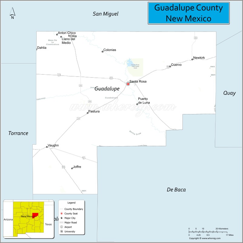
About Guadalupe County Map, New Mexico: The map showing the county boundary, county seat, major cities, highways, water bodies and neighbouring counties.
Other New Mexico Maps & Info
About Guadalupe County, New Mexico
Guadalupe County is a county located in the U.S. state of New Mexico. It's county seat is Santa Rosa. As per 2020 census, the population of Guadalupe County is 4449 people and population density is square miles. According to the United States Census Bureau, the county has a total area of 3,031 sq mi (7,850 km2). Guadalupe County was established on 1891.
Guadalupe County Facts
| Continent | North America |
| Country | United States |
| State | New Mexico |
| County Seat | Santa Rosa |
| Largest City/Town | Santa Rosa |
| Established | 1891 |
| Total Area | 3,032 sq mi (7,853 sq km) |
| Land Area | 3,030 sq mi (7,848 sq km) |
| Water Area | 2 sq mi (5 sq km) |
| Population | 4,468 (Census 2020) |
| Population Density | 1.5 people per sq mi |
| Time Zone | Mountain Time Zone |
| Major Highways | Interstate 40, U.S. Highway 54, U.S. Highway 84, State Road 91 |
| Major Rivers | Pecos River |
| Neighboring Counties | San Miguel County, Quay County, De Baca County, Torrance County, Lincoln County |
| Famous For | Route 66 history, Blue Hole, Pecos River recreation, and desert lake scenery |
| Top Attractions | Blue Hole, Santa Rosa Lake State Park, Route 66 Auto Museum, and Puerto de Luna |
| Official Website | Official Website |
About Guadalupe County, New Mexico
Guadalupe County is located in eastern-central New Mexico and was established in 1891. The county seat is Santa Rosa, which is also the largest city and a historic stop along Route 66 and Interstate 40. The county is known for natural spring-fed lakes, desert landscapes, ranching, and classic roadside attractions connected to the Mother Road.
Cities and Towns in Guadalupe County, New Mexico
| City/Town | Population (Census 2020) | Latitude & Longitude |
|---|---|---|
| Santa Rosa (county seat) | 2,848 | 34.9387°N, 104.6825°W |
| Vaughn | 539 | 34.6020°N, 105.2089°W |
| Puerto de Luna (CDP) | 141 | 34.8117°N, 104.6469°W |
| Anton Chico (partly CDP) | 188 | 35.1764°N, 105.1400°W |
| Pastura (ghost town area) | Historic community | 34.9639°N, 104.4064°W |
| Cuervo (historic settlement) | Historic community | 35.0142°N, 104.3986°W |
Golf Courses in Guadalupe County, New Mexico
| Golf Course | Location | Latitude & Longitude |
|---|---|---|
| Santa Rosa Golf Course | Santa Rosa | 34.9447°N, 104.6928°W |
| Santa Rosa Lake Recreation Golf Area | Santa Rosa | 34.9575°N, 104.7064°W |
Roads and Highways in Guadalupe County, New Mexico
Major highways connect the county to nearby regions and cities.
- Interstate 40 - major east-west interstate following the historic Route 66 corridor
- U.S. Highway 54 - north-south route connecting Vaughn with Tucumcari and Alamogordo
- U.S. Highway 84 - highway linking Santa Rosa with Fort Sumner and Santa Fe regions
- State Road 91 - former Route 66 alignment passing through historic roadside communities
Neighboring Counties of Guadalupe County
- San Miguel County (north)
- Quay County (east)
- De Baca County (south)
- Lincoln County (southwest)
- Torrance County (west)
Top Attractions in Guadalupe County, New Mexico
The county offers a mix of natural and cultural attractions.
- Blue Hole - famous natural spring and scuba diving destination in Santa Rosa
- Santa Rosa Lake State Park - recreation area for boating, fishing, and camping
- Route 66 Auto Museum - classic car museum celebrating Route 66 history
- Pecos River Recreation Areas - fishing and scenic picnic areas along the river corridor
- Puerto de Luna Historic Community - historic village with traditional New Mexico architecture
- Santa Rosa Historic Route 66 District - vintage motels, neon signs, and roadside attractions
- Park Lake and Perch Lake - spring-fed lakes popular for swimming and kayaking
- Santa Rosa Railroad Museum - exhibits covering local rail transportation history
- Cuervo Historic Ghost Town - abandoned Route 66 community with preserved ruins
- Vaughn Railway Junction - historic railroad crossing point in central New Mexico
- Power Dam Recreation Area - local outdoor recreation and fishing spot
- Eastern New Mexico Scenic Drives - open desert and prairie landscapes along historic highways
Distance from Guadalupe County to Nearby Cities
The following distances are measured by road (driving).
- Santa Rosa to Albuquerque (Bernalillo County), New Mexico - 117 mi (188 km)
- Santa Rosa to Tucumcari (Quay County), New Mexico - 59 mi (95 km)
- Santa Rosa to Fort Sumner (De Baca County), New Mexico - 59 mi (95 km)
- Santa Rosa to Santa Fe (Santa Fe County), New Mexico - 118 mi (190 km)
- Santa Rosa to Clovis (Curry County), New Mexico - 141 mi (227 km)
- Santa Rosa to Roswell (Chaves County), New Mexico - 117 mi (188 km)
- Santa Rosa to Amarillo (Potter County), Texas - 171 mi (275 km)
- Santa Rosa to Las Vegas (San Miguel County), New Mexico - 65 mi (105 km)
- Santa Rosa to Alamogordo (Otero County), New Mexico - 184 mi (296 km)
- Santa Rosa to Lubbock (Lubbock County), Texas - 242 mi (389 km)
- Santa Rosa to El Paso (El Paso County), Texas - 332 mi (534 km)
- Santa Rosa to Oklahoma City (Oklahoma County), Oklahoma - 395 mi (636 km)
FAQs about Guadalupe County
Guadalupe County is located in eastern-central New Mexico along Interstate 40 and historic Route 66.
The population of Guadalupe County was 4,468 according to the Census 2020.
Guadalupe County is known for Blue Hole, Route 66 history, Santa Rosa Lake, and Pecos River recreation.
The county is served by Interstate 40, U.S. Highway 54, U.S. Highway 84, and historic Route 66 alignments.
Yes, Guadalupe County has golf facilities including the Santa Rosa Golf Course.
References
- QuickFacts - U.S. Census Bureau
- United States Census Bureau
- United States Geological Survey (USGS)
- National Geodetic Survey
- Official County Website
- Bernalillo County Map
- Catron County Map
- Chaves County Map
- Cibola County Map
- Colfax County Map
- Curry County Map
- De Baca County Map
- Doña Ana County Map
- Eddy County Map
- Grant County Map
- Guadalupe County Map
- Harding County Map
- Hidalgo County Map
- Lea County Map
- Lincoln County Map
- Los Alamos County Map
- Luna County Map
- McKinley County Map
- Mora County Map
- Otero County Map
- Quay County Map
- Rio Arriba County Map
- Roosevelt County Map
- Sandoval County Map
- San Juan County Map
- San Miguel County Map
- Santa Fe County Map
- Sierra County Map
- Socorro County Map
- Taos County Map
- Torrance County Map
- Union County Map
- Valencia County Map
- Alabama Counties
- Alaska boroughs
- Arizona Counties
- Arkansas Counties
- California County Map
- Colorado Counties
- Connecticut Counties
- Delaware Counties
- Florida County Map
- Georgia County Map
- Hawaii Counties
- Idaho Counties
- Illinois Counties
- Indiana Counties
- Iowa Counties
- Kansas Counties
- Kentucky Counties
- Louisiana Counties
- Maine Counties
- Maryland Counties
- Massachusetts Counties
- Michigan County Map
- Minnesota Counties
- Mississippi Counties
- Missouri Counties
- Montana Counties
- Nebraska Counties
- Nevada Counties
- New York Counties
- New Hampshire Counties
- New Jersey Counties
- New Mexico Counties
- North Carolina Counties
- North Dakota Counties
- Ohio County Map
- Oklahoma Counties
- Oregon Counties
- Pennsylvania Counties
- Rhode Island Counties
- South Carolina Counties
- South Dakota Counties
- Map of Tennessee
- Texas County Map
- Utah Counties
- Vermont Counties
- Virginia Counties
- Washington Counties
- West Virginia Counties
- Wisconsin Counties
- Wyoming Counties