Written and Fact-checked by Whereig Editors, Reviewed by Mukesh Kumar| Updated On: May 15, 2026
Map of Lincoln County - Lincoln County is a county located in the U.S. state of New Mexico. Lincoln County Map showing cities, highways, important places and water bodies. Get Where is Lincoln County located in the map, major cities in Lincoln county, population, areas, and places of interest.
Map of Lincoln County, New Mexico
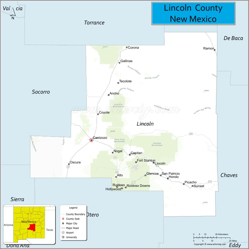
About Lincoln County Map, New Mexico: The map showing the county boundary, county seat, major cities, highways, water bodies and neighbouring counties.
Other New Mexico Maps & Info
About Lincoln County, New Mexico
Lincoln County is a county located in the U.S. state of New Mexico. It's county seat is Carrizozo. As per 2020 census, the population of Lincoln County is 20436 people and population density is square miles. According to the United States Census Bureau, the county has a total area of 4,831 sq mi (12,512 km2). Lincoln County was established on 1869.
Lincoln County Facts
| Continent | North America |
| Country | United States |
| State | New Mexico |
| County Seat | Carrizozo |
| Largest City/Town | Ruidoso |
| Established | 1869 |
| Total Area | 4,831 sq mi (12,512 sq km) |
| Land Area | 4,831 sq mi (12,512 sq km) |
| Water Area | 0.6 sq mi (1.6 sq km) |
| Population | 20,269 (Census 2020) |
| Population Density | 4.2 people per sq mi |
| Time Zone | Mountain Time Zone |
| Major Highways | U.S. Highway 54, U.S. Highway 70, U.S. Highway 380, State Road 48, State Road 37 |
| Major Rivers | Rio Bonito, Rio Ruidoso, Rio Hondo |
| Neighboring Counties | Torrance County, Guadalupe County, De Baca County, Chaves County, Otero County, Sierra County, Socorro County |
| Famous For | Billy the Kid history, Ruidoso mountain resort, Ski Apache, and Smokey Bear |
| Top Attractions | Lincoln Historic Site, Ruidoso, Ski Apache, and Smokey Bear Historical Park |
| Official Website | Official Website |
About Lincoln County, New Mexico
Lincoln County is located in south-central New Mexico and was established in 1869 during the territorial period. The county seat is Carrizozo, while Ruidoso is the largest community and a major tourism destination in the Sacramento Mountains. The county is known for its Old West history, mountain resorts, forests, horse racing, and outdoor recreation.
Cities and Towns in Lincoln County, New Mexico
| City/Town | Population (Census 2020) | Latitude & Longitude |
|---|---|---|
| Ruidoso | 7,679 | 33.3317°N, 105.6730°W |
| Carrizozo (county seat) | 930 | 33.6417°N, 105.8775°W |
| Capitan | 1,489 | 33.5451°N, 105.5722°W |
| Ruidoso Downs | 2,815 | 33.3315°N, 105.6128°W |
| Corona | 129 | 34.2495°N, 105.5969°W |
| Alto (CDP) | 1,104 | 33.3953°N, 105.6806°W |
| Nogal (CDP) | 137 | 33.5401°N, 105.7167°W |
| Lincoln (historic village) | Historic community | 33.4920°N, 105.3830°W |
| Glencoe (CDP) | 210 | 33.3792°N, 105.4764°W |
| Fort Stanton (historic area) | Historic community | 33.4862°N, 105.5239°W |
Golf Courses in Lincoln County, New Mexico
| Golf Course | Location | Latitude & Longitude |
|---|---|---|
| The Links at Sierra Blanca | Ruidoso | 33.3472°N, 105.6564°W |
| Cree Meadows Public Golf Course | Ruidoso | 33.3381°N, 105.6745°W |
| Alto Lakes Golf and Country Club | Alto | 33.3994°N, 105.6847°W |
| Inn of the Mountain Gods Golf Course | Mescalero area | 33.3036°N, 105.6761°W |
Roads and Highways in Lincoln County, New Mexico
Major highways connect the county to nearby regions and mountain communities.
- U.S. Highway 54 - major north-south route serving Carrizozo and Corona
- U.S. Highway 70 - scenic highway connecting Ruidoso with Roswell and Las Cruces
- U.S. Highway 380 - east-west route linking Carrizozo with central and eastern New Mexico
- State Road 48 - highway connecting Ruidoso and Alto mountain resort areas
- State Road 37 - scenic road serving Capitan and nearby recreation areas
Neighboring Counties of Lincoln County
- Torrance County (north)
- Guadalupe County (northeast)
- De Baca County (east)
- Chaves County (southeast)
- Otero County (south)
- Sierra County (west)
- Socorro County (northwest)
Top Attractions in Lincoln County, New Mexico
The county offers a mix of natural, cultural, and historical attractions.
- Lincoln Historic Site - preserved Old West village associated with Billy the Kid and the Lincoln County War
- Ruidoso - mountain resort town known for shopping, casinos, and outdoor recreation
- Ski Apache - popular ski resort located in the Sierra Blanca mountains
- Smokey Bear Historical Park - museum and memorial dedicated to the famous wildfire prevention mascot
- Ruidoso Downs Race Track - horse racing venue and home of the All American Futurity
- Fort Stanton Historic Site - former military fort and historic landmark
- Grindstone Lake Recreation Area - boating, fishing, hiking, and camping destination
- Bonito Lake - scenic mountain lake surrounded by forest landscapes
- White Mountain Wilderness - hiking and wildlife viewing area in the Sacramento Mountains
- Hubbard Museum of the American West - museum focused on western culture and horse history
- Valley of Fires Recreation Area - volcanic lava flow landscape near Carrizozo
- Mescalero Apache cultural areas - nearby Native American cultural attractions and resorts
Distance from Lincoln County to Nearby Cities
The following distances are measured by road (driving).
- Ruidoso to Roswell (Chaves County), New Mexico - 75 mi (121 km)
- Ruidoso to Alamogordo (Otero County), New Mexico - 69 mi (111 km)
- Ruidoso to Las Cruces (Dona Ana County), New Mexico - 139 mi (224 km)
- Ruidoso to Albuquerque (Bernalillo County), New Mexico - 181 mi (291 km)
- Ruidoso to Santa Fe (Santa Fe County), New Mexico - 206 mi (332 km)
- Ruidoso to El Paso (El Paso County), Texas - 154 mi (248 km)
- Ruidoso to Carlsbad (Eddy County), New Mexico - 136 mi (219 km)
- Ruidoso to Clovis (Curry County), New Mexico - 149 mi (240 km)
- Ruidoso to Amarillo (Potter County), Texas - 286 mi (460 km)
- Ruidoso to Midland (Midland County), Texas - 256 mi (412 km)
- Ruidoso to Tucson (Pima County), Arizona - 363 mi (584 km)
- Ruidoso to Phoenix (Maricopa County), Arizona - 431 mi (694 km)
FAQs about Lincoln County
Lincoln County is located in south-central New Mexico within the Sacramento Mountain region.
The population of Lincoln County was 20,269 according to the Census 2020.
Lincoln County is known for Billy the Kid history, mountain tourism, Ski Apache, and Smokey Bear.
The county is served by U.S. Highway 54, U.S. Highway 70, U.S. Highway 380, and scenic mountain roads.
Yes, Lincoln County has several golf facilities including The Links at Sierra Blanca and Alto Lakes Golf and Country Club.
References
- QuickFacts - U.S. Census Bureau
- United States Census Bureau
- United States Geological Survey (USGS)
- National Geodetic Survey
- Official County Website
- Bernalillo County Map
- Catron County Map
- Chaves County Map
- Cibola County Map
- Colfax County Map
- Curry County Map
- De Baca County Map
- Doña Ana County Map
- Eddy County Map
- Grant County Map
- Guadalupe County Map
- Harding County Map
- Hidalgo County Map
- Lea County Map
- Lincoln County Map
- Los Alamos County Map
- Luna County Map
- McKinley County Map
- Mora County Map
- Otero County Map
- Quay County Map
- Rio Arriba County Map
- Roosevelt County Map
- Sandoval County Map
- San Juan County Map
- San Miguel County Map
- Santa Fe County Map
- Sierra County Map
- Socorro County Map
- Taos County Map
- Torrance County Map
- Union County Map
- Valencia County Map
- Alabama Counties
- Alaska boroughs
- Arizona Counties
- Arkansas Counties
- California County Map
- Colorado Counties
- Connecticut Counties
- Delaware Counties
- Florida County Map
- Georgia County Map
- Hawaii Counties
- Idaho Counties
- Illinois Counties
- Indiana Counties
- Iowa Counties
- Kansas Counties
- Kentucky Counties
- Louisiana Counties
- Maine Counties
- Maryland Counties
- Massachusetts Counties
- Michigan County Map
- Minnesota Counties
- Mississippi Counties
- Missouri Counties
- Montana Counties
- Nebraska Counties
- Nevada Counties
- New York Counties
- New Hampshire Counties
- New Jersey Counties
- New Mexico Counties
- North Carolina Counties
- North Dakota Counties
- Ohio County Map
- Oklahoma Counties
- Oregon Counties
- Pennsylvania Counties
- Rhode Island Counties
- South Carolina Counties
- South Dakota Counties
- Map of Tennessee
- Texas County Map
- Utah Counties
- Vermont Counties
- Virginia Counties
- Washington Counties
- West Virginia Counties
- Wisconsin Counties
- Wyoming Counties